Here’s when hail, winds hit Dallas-Fort Worth after thunder, lightning dazzle overnight
Many in Dallas-Fort Worth got a taste of storms to come as thunder rumbled and lightning flashed in the wee hours of Thursday, but the worst of the severe storms are expected to hit later in the day, according to the National Weather Service Fort Worth office.
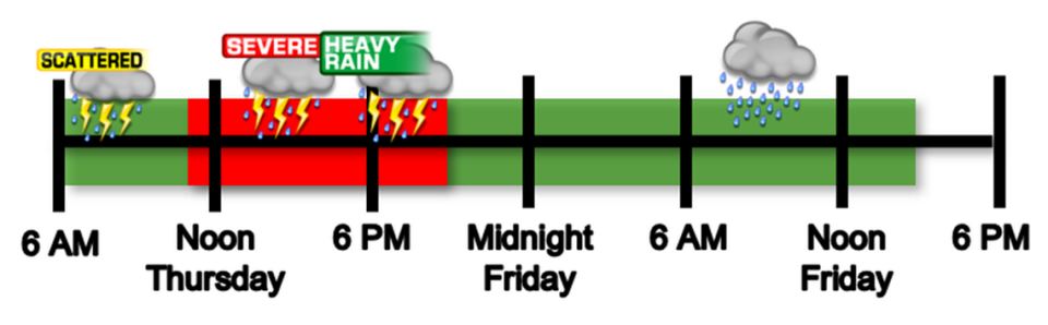
“Some showers and storms may occur overnight [Wednesday into Thursday], but widespread showers and thunderstorms are expected across most of the area on Thursday and Thursday night,” the NWS forecast states. “While scattered strong storms are possible Thursday morning, the main timing for flooding and severe thunderstorms will be Thursday afternoon and evening.”
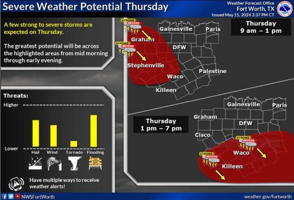
The main threats from the new storms are hail and damaging winds with the slight possibility of tornadoes. Flooding is feared mostly in areas south of I-20 with 1 to 3 inches of rainfall expected across the region, and even higher totals in some areas. Parts of Central Texas may see rain totals of up to 3-4 inches.
⚡ More trending stories from our newsroom:
→ Supermodel Bella Hadid moves to Fort Worth to be with cowboy.
→ If you quit a job in Texas, you could still get unemployment
→ Is this 50-acre Fort Worth ranch really worth $15.9M?
The weather disturbance began early Thursday morning, stretching from Wichita Falls all the way to Houston, according to Fort Worth meteorologist Matt Stalley. But the flashy show is but a prelude for the hammer dropping later in the day.
“This sub-severe activity is likely to continue through the morning while eventually moving off to the northeast,” Stalley wrote on the NWS website. Outside of some small hail and brief heavy rainfall, this activity will be rather inconsequential compared to [the storms] later [Thursday].”
Starting north and west of the Dallas-Fort Worth region, the new storms will intensify just after daybreak as it begins its move eastward from El Paso. By between 7 and 10 a.m., the NWS expects this roiling mass to slam into unstable air over North and Central Texas, likely giving it the lift that can spawn storms with feared ferocity.
“This activity will be capable of very heavy rainfall with rates perhaps near 2” per hour, as well as large hail and damaging wind threats, the primary of which will be dependent on eventual convective mode,” Stalley wrote.
Earlier in the week, parts of the Metroplex came under a flood watch as an already waterlogged region awaited even more rain. This pattern of storms is normal for North Texas this time of the year. Just days ago the region braced for strong storms with large hail and possible tornadoes in the mix. Threats of severe storms are serious for a region that, in the past 20 years, have seen the frequency and severity of storms increase.
More rain is expected through Friday morning but things are bound to dry out by the weekend, according to the NWS forecast.

