Frigid February: Polar vortex poised to bring ultra-cold air to Canada, U.S.

The Midwest and East Coast endured a record cold end to 2017 and start of 2018. Residents there should get ready to do it again, while those living in normally cold places, like the Arctic and Alaska, should prepare to see their weather flip back to much above average temperatures, along with the havoc wreaked by melting ice and snow at this time of year.
SEE ALSO: 2017 was one of Earth's top 3 hottest years on record, which should come as no surprise
To get a sense of weather conditions in the long range, meteorologists use ensemble models, which consist of a computer model that is run many times with varying initial conditions each time. Those models now show a remarkable consensus between the ensembles of two major computer models that forecasters use, the Global Forecast System, or GFS, and the European Model, known as the ECMWF.
Both models show the building of an unusually strong ridge, or area of high pressure, in the middle and upper atmosphere across Alaska in the coming one to two weeks. The European model, in particular, is quite aggressive in projecting a powerhouse ridge that will extend from the North Pacific all the way into the Arctic.
This could bring a resumption of warm winter conditions back to Alaska after the state recorded its warmest December in its history, and it will also redirect weather systems in ways that will have consequences for areas located thousands of miles away.
The ridge will cause the jet stream to snap southward, directing frigid air from northern Canada and possibly even Siberia southward, crossing the U.S. border during the first week of February.
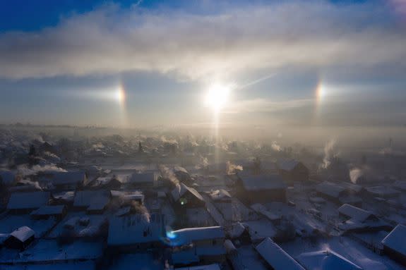
Image: Kirill Kukhmar/TASS via Getty Images
From there, things get more hazy, since this is a long-term forecast, but any time there is a huge buildup of extremely cold air in south-central Canada, one needs to consider the possibility that it will slide south, into the U.S., and gradually put cities from Minneapolis to Chicago to New York back into the deep freeze.
One wild card in forecasting the evolution of this weather pattern is that the coldest air could remain bottled up in Canada and the northern tier of the U.S., thereby plunging the Upper Midwest and northern Plains into the deep freeze. On occasion, waves of frigid air could break off and move southeastward, toward the Ohio Valley and East Coast. This scenario would not result in the sort of prolonged cold that occurred along the East Coast in late December and early January.
The overall weather pattern, with the massive ridge off the West Coast, and another ridge off the East Coast, will be ideal for an Arctic outbreak in the U.S.
Judah Cohen, the director of seasonal forecasting at AER, a Verisk company, said he foresees that part of the polar vortex itself will whirl its way south, above North America.
He said the behavior of the polar vortex, which is an area of low pressure at upper levels of the atmosphere, whose circulation plays a key role in determining where the coldest air will be, reminds him of the notorious winter of 2013-14. That winter, referred to in much of the U.S. as the polar vortex winter, also saw the vortex slide south, taking the coldest air with it.
Models do best when predicting amplified flow. Hard to imagine better agreement on large scale pattern of a 10-day forecast between GFS and ECMWF for North America than today's forecast. Consensus is #cold! pic.twitter.com/2Y0fiJrrnY
— Judah Cohen (@judah47) January 25, 2018
This winter, the polar vortex has affected Eurasia in particular, with impressive cold — on the order of minus 80 degrees Fahrenheit — taking hold in Siberia. Cohen said it's "really pretty rare" to see the vortex meander south into North America, including the U.S., but that may be what's about to happen.
I would rather be tweeting about #PolarVortex splits but in the meantime still fascinated by GFS forecast of polar vortex displacement into North America (not including Greenland), which is highly unusual! pic.twitter.com/8vApIdG68D
— Judah Cohen (@judah47) January 25, 2018
As for the sensible weather details, the core of the cold is likely to set up shop in the Northern Plains and Central Canada during the first 10 days of February. After that, it may slide east-southeast, toward the East Coast with time.
The specific details of how cold it will get compared to average, and whether there will be any significant storms accompanying this weather pattern, much as the bomb cyclone did, will become clearer during the coming days because of the uncertainties involved with medium- to long-range forecasting.
There's a tropical connection to the cold
It may not be an accident that this weather pattern is occurring again during a La Niña event. Such events feature unusually mild waters in the Western Tropical Pacific Ocean, but cooler than average waters in the Central and Eastern Tropical Pacific.
According to Michael Ventrice, a meteorologist for The Weather Company, which is part of IBM, such weather patterns tend to emerge when the Pacific Jet Stream is intensified by an uptick in showers and thunderstorms across the Western Pacific Ocean and Indonesia during La Niña years. The jet stream is the highway of air at the upper levels of the atmosphere that steers weather systems and separates air masses.
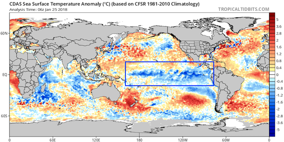
Image: tropical tidbits
"These patterns commonly emerge when the Pacific Jet Stream is excited by enhanced tropical convection over the Maritime Continent into the West Pacific," Ventrice said. Another factor at play is known as the Madden-Julian Oscillation, or MJO, which is a cycle of enhanced showers and thunderstorms that travels eastward around the equator and gets back to its starting point within one to two months, on average.
The MJO has further heightened showers and thunderstorms over the Western Pacific in recent weeks, Ventrice said in an email. "This translates to an explosion of tropical convection over the Maritime-Continent and West Pacific. Essentially this is feeding the low-frequency La Niña base state gasoline ... making the engine go into overdrive," he said.
"The last time we observed the MJO 'gas up' the La Niña state was back in late November through mid-December," he said. That was followed soon afterward by the record cold snap in the U.S.
Planning to visit the Twin Cities for @MNSuperBowl2018? @CIPSAnalogs extended continues to say bring plenty of warm clothes with arctic air making it's return as the calendar flips to February! #mnwx #BoldNorth pic.twitter.com/lH4zvvXcwP
— NWS Twin Cities (@NWSTwinCities) January 25, 2018
The interaction between the MJO and La Niña eventually will help create an unstable jet stream across the North Pacific. When it breaks down, which is predicted to happen during the next couple of weeks, unusually warm, tropical air pushes its way north toward Alaska and the North Pole, creating the mega-ridge of high pressure.
"That big blocking high over the North Pacific is what is going to disrupt the Arctic Circle, flooding the area with anomalous warmth," Ventrice said. "This process displaces the cold air pooling over the North Pole down towards the U.S."
"By flooding the North Pole with warm air, it displaces arctic cold air into the midlatitudes, with one specific pathway down across North America," he said.
The Arctic is heading into this relative warm spell in a weakened state, with sea ice cover running near or at record lows for this time of year. The flip side to the upcoming Arctic warming will be colder weather in the lower 48 states.
"This means an increased frequency of bitter cold days in the U.S. looking ahead into February," Ventrice said. "And with cold air comes winter storms... so expect snow cover to increase across the U.S. with a window for coastal Nor'easter snow storms (i.e., the #bombcyclone) between February 14 through March 6," he said.
So, snow lovers, get excited.
(Just not too excited, considering the uncertainties involved with long-range forecasting.)
WATCH: Monkeys are being cloned inside a Chinese lab. This is what they look like.