Florida hurricane threat reveals forecasting challenges in social media era
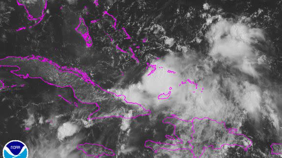
Right now, there's a broad area of disturbed weather extending from Cuba to Hispaniola. It's a messy storm system from a meteorological perspective, lacking any cohesion and the familiar, tightly wound swirling motion we're used to seeing in mature tropical storms and hurricanes.
But the tropical wave, named "Invest 99L" by the National Hurricane Center, has the potential to become a big troublemaker for Florida and other Gulf Coast states if it manages to get its act together and intensify. It has had that potential for days.
SEE ALSO: Connecting the dots on 2016’s extreme summer weather and global warming
However, communicating the storm's potential, while also being clear about the uncertainty involved in this forecast, has challenged the evolving weather communication ecosystem in which social media plays an outsized role.
Digital media outlets, including Mashable, have been covering the storm potential for several days since if the weather system intensifies into a hurricane and tracks toward Florida it would become the first such storm to hit there since 2005.
That's a record long hurricane drought, during which time at least the population of Miami-Dade county alone swelled by 307,245 people.
So the need to warn a vulnerable population is driving much of the media coverage, which is a good thing, meteorologists told me via Twitter message exchanges on Friday.
However, too much of a good thing, plus misuse of computer model guidance, can leave the public misinformed, they said. Some media outlets even seemed to take the hurricane as a given. For example, USA Today ran a story on Friday that raised the prospect of a hurricane that would aggravate the Sunshine State's Zika virus outbreak.
Those that are seeking social media click-bait will post the most disastrous model run," said Ryan Maue, a meteorologist for WeatherBell Analytics, a private forecasting company. However, the fact that everyone is talking about a "potential" hurricane in Florida or the Gulf is exactly what we want as meteorologists to have the public cognizant of threats."
According to Maue, the firehose of weather data available to the public is not necessarily leading to better communication by professional forecasts.
"There's too much superfluous information out there — all of the underlying data is flooding the Internet — which is drowning out the actual value-added, experienced forecaster products," Maue said.
"Social media can now watch the sausage factory in real time and weather models are constantly updated continually feeding the beast. Content!"
Eric Blake, a hurricane specialist at the National Hurricane Center in Miami, sees the social media discussions of storm forecasts as an evolution of debates that used to take place in other forums rather than something new.
"To me it is just the evolution of the way people communicate — faster speed but shorter attention span," he told Mashable. "It is a serious challenge because often it is difficult to determine credible information sources as a member of the general public."
In many ways, "Invest 99L" is ideal for causing trouble on the weather communications front.
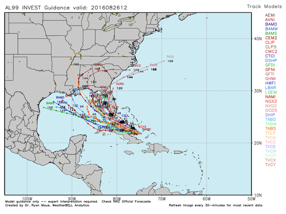
Image: weatherbell analytics
It is a loosely organized disturbance that is close to the U.S., meaning that if it does intensify, the amount of time that coastal residents will have to prepare for it could be limited. Its proximity to the coast also means there is a heightened media interest in it, including from non-meteorologists.
Michael Ventrice, a scientist at The Weather Company, said that "Invest 99L" has resulted in a lot of spin online.
"Anytime you have an incipient disturbance close to home, you have to give it the attention it demands for risk assessment," he said. "While social media is a great tool for news, as you know, it can also cause confusion. Meteorologists are not fortune tellers, so they give their best educated opinion. Everyone has an opinion, thus you're seeing a number of people voice what they honestly believe may happen."
As for his own thoughts on the forecast, Ventrice says the next 36 hours will determine the fate of Invest 99L, as upper level wind shear wanes, providing a more favorable environment for the tropical disturbance to intensify.
"I'm not writing off 99L in any way at the current time," he said. "I want to see how 99L does in the reduced shear environment later tomorrow. There's still a credible risk of a Gulf of Mexico tropical cyclone," he said.
The Hurricane Center is giving Invest 99L a 60 percent chance of becoming a tropical cyclone within the next 5 days. Even if the system does not intensify dramatically, it could bring heavy rain to Florida and other areas along the Gulf Coast beginning this weekend.
If it does intensify into a tropical storm or hurricane, it would be named Hermine.
