Life-threatening flooding problems to expand across southern US
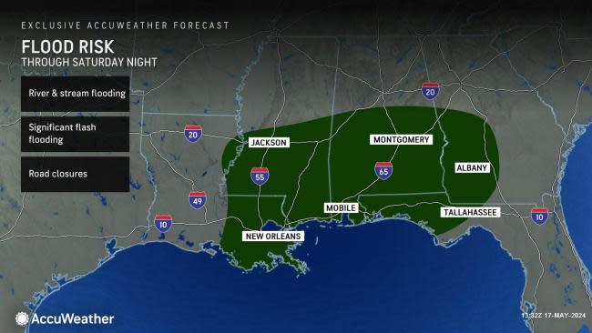

Areas throughout the South are bracing for the serious flooding consequences of 4-8 inches of rain and locally higher amounts into the start of this weekend, in addition to severe thunderstorms, AccuWeather meteorologists warn.
The atmosphere is not ready to let go of the pattern responsible for rounds of heavy rain in parts of the southern United States since April. A large and slow-moving storm that moved eastward over the middle of the nation has pulled copious amounts of moisture northward over the Interstate 10 and 20 corridors of the central Gulf Coast states before arriving in the Southeast. Effectively, this will be the caboose in a long train of storm systems. The tail-end storm is often potent, and this may be no exception.
AccuWeather meteorologists remain highly concerned about the severity of the flooding that could evolve for the start of the weekend and have warned of the ongoing rounds of rain and the consequences.
Although people may be tired of this rainy pattern across the southern part of the U.S. and the recent watches and warnings from the National Weather Service, they are issued for good reason, AccuWeather Chief Meteorologist Jon Porter said.
"But now is not the time to turn off any of those notifications," Porter cautioned, "In fact, now is the time to ensure you have multiple ways to get warnings."
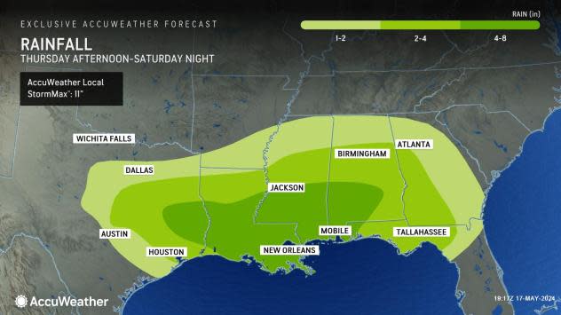
AccuWeather meteorologists' latest prognosis is that at least a half-dozen states will receive 2-4 inches of rain from late this week to early this weekend. However, double that amount will occur within that zone, with an AccuWeather StormMax™ of 11 inches. In many cases, that rain will fall in under 12 hours. In some locations, that sort of rain may fall in as little as a few hours.
Since the second week of April, rainfall has been two to three times the historical average in many areas. In some cases, 20-30 inches of rain has fallen, which is six times that of average. Much of that rain fell in several days and led to a rapid runoff into area streams, rivers and bayous.
 |
Not only will enough new rain pour down to trigger flash urban and small stream flooding, but also many rivers in the region will be on the rise. People living along stretches of rivers that do not have protection from rising water will be at risk. In some cases, the flooding may be close to or may even exceed that of the past couple of weeks. Other areas that have not experienced river flooding in prior weeks could face issues.
The ground has become saturated over a multistate area of the South.
When the ground is saturated, nearly all of that rain immediately runs off into catch basins, low-lying areas (such as underpasses) and small streams, Porter said.
The water can cause infrastructure damage, and roads can become inundated by rising water in minutes to seconds -- which is very dangerous for motorists. In other situations, the saturated ground could give way along roads along or over small streams without any notice. Bridges could be washed out along secondary roads in this situation.
"You can end up with a cascading set of flooding problems that can quickly escalate into a life-threatening emergency," Porter warned.
While there have been some intervals of rain-free weather between deluges, those breaks have not been enough to allow streams and rivers to recede to the point where they can reasonably handle more rain.
In the past few weeks, rounds of torrential rain have periodically caused rivers to surge from northeastern Texas to southern Alabama and northern Florida. In portions of northeastern Texas, major river flooding has occurred.
 |
Rivers that should be watched for water rising to new heights include but are not limited to the Trinity, San Jacinto, and Neches in Texas; the Sabine River along the Texas/Louisiana border; the Calcasieu River in Louisiana; the Pearl River in Mississippi and the Alabama and Tombigbee rivers in Alabama. However, many more rivers, creeks and bayous in the region will be surging as more rain evolves and even days after the rain moves away later this weekend or next week.
Motorists should be prepared for roads to become blocked by floodwaters and should avoid flood-prone areas. In some cases, waters may rise rapidly and quickly engulf even large vehicles along small streams and low-lying areas.
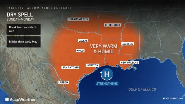
In the wake of the slow-moving storm to affect the region from late this week to this weekend, a change in the pattern is in store for much of the I-10 and 20 corridors of the South Central and Southeast states.
"Incidents of frequent heavy rain will likely set up farther to the north over the central Plains and Midwest," AccuWeather Lead Long-Range Meteorologist Paul Pastelok said. "Instead, portions of the I-10 and 20 corridors of the South Central and Southeast states will bask in building heat and humidity without the nearly daily threat of severe thunderstorms and deluges."
 |
There can still be heavy thunderstorm activity but on a much smaller, localized scale.
Despite the upcoming west-to-east drying trend, it could take weeks for some of the largest rivers nearest the coast to drop below flood stage. Water levels on the Mississippi River may continue to fluctuate as rounds of heavy rain occur to the north over portions of the Ohio and Missouri rivers, which are major tributaries.
Want next-level safety, ad-free? Unlock advanced, hyperlocal severe weather alerts when you subscribe to Premium+ on the AccuWeather app. AccuWeather Alerts™ are prompted by our expert meteorologists who monitor and analyze dangerous weather risks 24/7 to keep you and your family safer.
