The first photo from a new Earth-gazing satellite is insanely detailed

A brand new satellite orbiting hundreds of miles above Earth's surface has just opened its eyes.
DigitalGlobe released the first public photo taken by the company's Earth-gazing WorldView-4 satellite, and it's a beauty.
The new image, taken on Nov. 26 and unveiled last week, shows Tokyo, Japan's Yoyogi National Gymnasium, one of the sites of the 1964 Olympics.
SEE ALSO: The first photo of Earth from space was taken 70 years ago
WorldView-4 is the latest advanced satellite in a fleet of five DigitalGlobe spacecraft designed to beam high-resolution images of various places on Earth back to people on the ground.
The details in the new photo are impressive, especially considering that the image was taken from 617 kilometers, or about 383 miles, above the planet. Cars and trucks can be seen on roads and in parking lots, and stretching shadows of soccer players fan out on pitches on the upper-left portion of the photo.
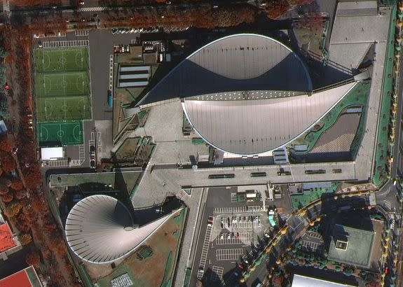
Image: IMAGE COURTESY © DIGITALGLOBE 2016
The difference between WorldView-4's first photo and some of the early images taken by DigitalGlobe's Ikonos satellite, which launched in 1999 and took its last photo in 2014, are like night and day.
Black and white Ikonos images clearly show large-scale features of different areas, but the detail is lost, limiting the number of applications available to users of the data.

Image: Image courtesy of digitalglobe
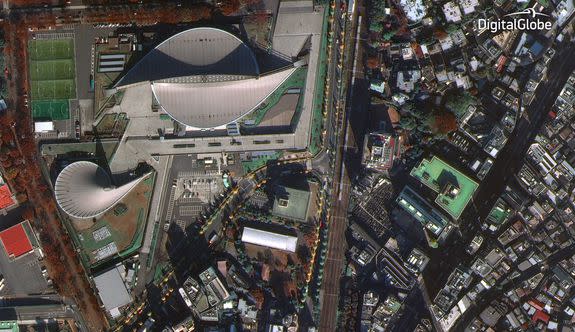
Image: image courtesy of Digitalglobe
http://blueprint-api-production.s3.amazonaws.com/uploads/card/image/307395/f786c700ea714096b6497f3083cbc369.jpg
All in all, WorldView-4 will provide 680,000 square kilometers (a bit less than the size of Texas) of imagery to DigitalGlobe's database every day.
Clients like Google use those images to create maps, provide help to aid organizations after disasters, and other applications.
DigitalGlobe isn't the only commercial company in the Earth imagery game. In fact, this is a rapidly expanding area, though DigitalGlobe stands out for its sizable government business with secretive organizations like the National Reconnaissance Office.
Start-ups like Orbital Insight, Planet and Spire want to use small satellites and big data to analyze images quickly to track issues like deforestation and even track aircraft and provide insight about the weather.
