Final community input gathered on Padre and Mustang islands mobility plan
City of Corpus Christi officials and HDR, a local engineering consultant, held a Community Open House on Monday, April 15, to gather additional feedback on the Padre/Mustang Island Mobility Plan.
The plan is a multimodal transportation study initiated by the city to further previous planning efforts conducted for the area.
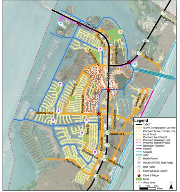
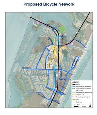
It identifies walking, cycling, golf cart and watercraft pathways that connect residential neighborhoods to commercial and retail locations and critical routes, analyzing the effectiveness of those routes while taking into consideration the recommendations from previous planning efforts and current development projects.
Held at the Seashore Middle Academy Cafeteria on North Padre Island, Monday's meeting marked the second Community Open House held to identify priorities for the different modes of transportation within the existing roadways and give members of the public more information about current and proposed streets and facilities. There was the opportunity to comment on high-level cross sections and design standards where they would like to see dedicated facilities to be included in the Final Draft Recommendations for the plan before it is presented to the City Council for adoption.
The first Community Open House was held last October to provide a mobility network overview of existing bicycle, pedestrian and golf facilities with the opportunity to comment on boards presented during the meeting.
Guests were presented with board cross sections depicting existing conditions and future visions for island corridors, including identifying existing streets with public right of way (ROW) to expand pavement to provide space for dedicated facilities for pedestrians, bicycles, and shared lanes for vehicles and golf carts and neighborhood electric vehicles (NEVs), as well as interim recommendations for streets that fall within existing ROW but that lack the infrastructure needed to fulfill long-term project goals.
They wrote their recommendations on sticky notes and attached them to the design schematics displayed around the room.
Some proposed streets, including Sand Dollar Avenue, which would be a parallel facility to Park Road 22, would have dedicated bike lanes and sidewalks for pedestrians and cyclists to travel north and south and access retail stores. The second segment would recommend using the full 50 feet of ROW to design and construct the corridor to include dedicated facilities for pedestrians and a shared use path for bikes, golf carts, and NEVs, pending City Council adoption and design modifications that could be made based on funding.
Many comments left on the boards indicated a strong need for better connectivity on existing lanes and roads that lack bike lanes with physical barriers, pedestrian crosswalks, better lighting and signage at busy intersections, and access routes for golf carts.
The first Community Open House was held last October to provide a mobility network overview of existing bicycle, pedestrian and golf facilities with the opportunity to comment on boards presented during the meeting.
The project began in spring of 2023 with a Padre/Mustang Island Mobility Existing Conditions Memorandum, which assessed current conditions of the area of study. It was designed to further the initiative of the 2021 Padre/Mustang Island Area Development Plan to promote tourist-oriented development east of State Highway 361/Park Road 22 and between Zahn Road and Whitecap Boulevard by providing public and private amenities and multimodal transportation.
The city introduced the project to the Island Strategic Action Committee (ISAC) during a Project Introduction Information Meeting on Aug. 4, 2023, and conducted an initial community online survey between Aug. 7 and Aug. 25 and a second online survey between Nov. 3 and Nov. 19 as further community engagement strategies.
"This plan is primarily focused on pedestrians, cyclists and golf car users, to create a safe comprehensive network for mobility," said Roger Montelongo, Economic Development Special Projects Manager - Padre Island Liaison for the City of Corpus Christi Office of Economic Development. "What it will do is lay the vision of what's going to go there, so when the designers go to work, they'll at least have some design standards to work from before delving into more granular details with utilities and underground work."
He said that while the plan initially only considered Park Road 22, public feedback indicated that people want a more comprehensive network, prompting the need for a more thorough overview of the island's infrastructure to eventually guide development on the roads.
The cross sections presented at the meetings will help do that, he said.
"Now that we've gone through and done our research and analysis based on previous work, we're bringing all of our recommendations back to the public," Montelongo said.
He thanked Councilmember of District 4 Dan Suckley for his full support and advocacy of the plan.
Dan McGinn, director of the city Planning Department, said the plan will help increase mobility on the island and help the council identify areas of high priority, as well as those that could receive Tax Incentive Reinvestment Zone (TIRZ) funding--primarily high-density corridors carrying heavy vehicle traffic.
City leaders are anticipating City Council adopting the plan this May or June.
This article originally appeared on Corpus Christi Caller Times: City gathers public input on Padre and Mustang islands mobility plan
