Severe storms, tornadoes to threaten southeastern US
Severe thunderstorms, including a few tornadoes will threaten lives and property across the Southeast early this week.
The system that ignited a few severe storms over central Texas to close out the weekend will encounter warm and humid air from the Tennessee Valley to part of the southern Atlantic Coast into Tuesday.
"The atmosphere is primed for a severe weather outbreak in the South," AccuWeather Senior Meteorologist Frank Strait said.
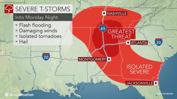
Strait anticipates areas from Tennessee to Alabama and Georgia to face thunderstorms that could produce large hail and strong winds capable of snapping tree branches and downing power lines.
"There will be enough of the right ingredients in place for a few tornadoes as well," Strait said. Some of the tornadoes could be strong.
Drivers along portions of interstates 10, 20, 22, 40, 59, 65, 75, 85 and 95 will be at risk of encountering downpours that can drastically reduce visibility and heighten the risk of hydroplaning.
"A wedge of cool air from the Atlantic Ocean should protect most areas in the Carolinas from the violent storms with this particular event," according AccuWeather Senior Meteorologist Alex Sosnowski.
It will be important for residents who may be preoccupied with daily routines to keep an eye out for rapidly changing weather conditions and stay up-to-date on the latest severe weather watches and warnings.
Anyone caught outside should seek shelter indoors and away from windows at the first rumble of thunder as this means there is a risk of being struck by lightning.
The severe weather risk will likely spread southward heading on Tuesday, potentially threatening MLB spring training games and spring break vacation plans in Florida.
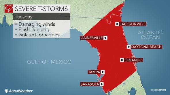
Damaging storms could impact Jacksonville, Clearwater, Lakeland, Daytona Beach, Melbourne, Tampa, Orlando and surrounding communities. Residents and visitors in these areas should prepare for possible power outages and tree damage.
The risk of isolated tornadoes will continue on Tuesday.
People heading to Grapefruit League spring training games should keep an eye out for darkening, billowing clouds and be prepared to follow evacuation procedures if thunderstorms do approach.
The rainfall early this week will largely be beneficial as portions of the southern Atlantic Seaboard remain in abnormally dry to severe drought conditions, according to the latest U.S. Drought Monitor.
However, the storms may pack too much rainfall in a short span and trigger urban, poor drainage and small stream flooding.
Colder air will sweep across the South behind the storm, subsequently ending the threat for severe weather.
"The risk of severe storms will have ended from Tennessee and Alabama to central Georgia and much of the Florida Panhandle on Tuesday," Sosnowski said. "It is possible there is enough warming to allow storms to fire along the Georgia and South Carolina coast during Tuesday midday. By Wednesday the risk will have ended over the Florida Peninsula."
However, the cold air combined with lingering moisture could lead to some snow in parts of Tennessee Valley and the southern Appalachians during Tuesday night and into early Wednesday.
Parts of the Southeast may face another freeze in the wake of the storm.
Similar to last week, residents will once again need to take precautions to protect sensitive vegetation.
