Extreme weather across the heartland including possible tornadoes
Extreme weather is set to hit much of the central area of the United States as severe thunderstorms are due along with possible tornadoes and large hail.
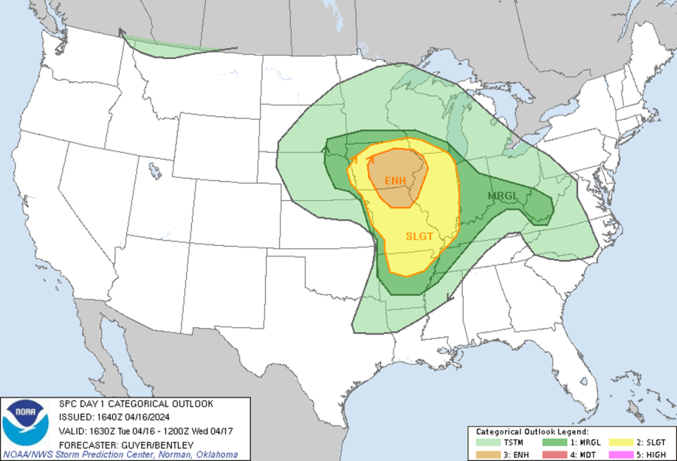
A large storm hitting the heartlands over the next few days is expected to result in severe thunderstorms on Tuesday, the National Weather Service announced, as a Level 3 out of 5 enhanced risk for the thunderstorms was declared.
The weather experts say that scattered severe thunderstorms are likely, centred mostly over midwestern states like northern Missouri, Iowa, northwestern Illinois and far southwest Wisconsin this afternoon and this evening.
Isolated weather events could also crop up as far south as the Ozarks of northern Arkansas.
The service warns that all forms of severe weather are possible, including tornadoes, a few of which they suggest could be very strong.
They also predict very large two-plus inch sized hail and damaging wind gusts of up to 70mph are also possible.
Tornado watches have been issued for portions of Illinois, Iowa, Missouri and Wisconsin until 8pm CDT, the NWS announced, exposing over 2.3m people to the extreme weather.
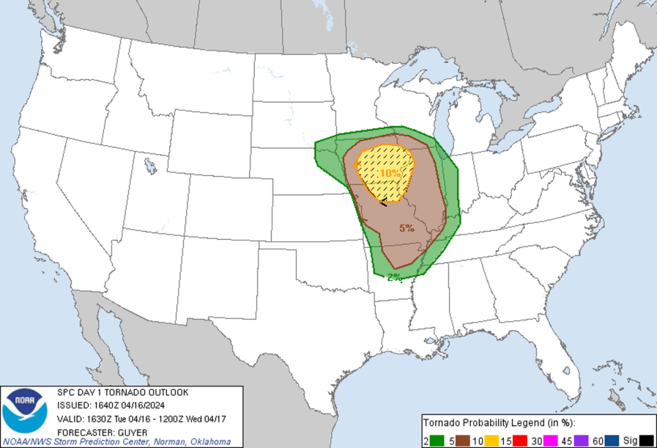
A further tornado watch has also been deployed as the day progressed for parts of Iowa, Nebraska and South Dakota until 7pm CDT, encompassing over 600,000 residents, the agency has added in an update.
Multiple areas of Nebraska and Iowa have also been put under tornado warnings.
The harsh weather has already taken its toll in other areas, such as parts of Kansas, Missouri and Iowa, which have all reported tornadoes, according to the Weather Channel.
Golf ball-sized hail came crashing down in the suburbs in Washinton DC and winds close to 70mph also brought trees crashing down in Virginia, ABC reports.
Scattered severe thunderstorms are likely today across the Midwest.
Timing: This afternoon and evening
Hazards: All severe weather hazards are possible including tornadoes, a few which may be strong, very large hail, and damaging wind gusts. pic.twitter.com/0gsJW7scbk— NWS Storm Prediction Center (@NWSSPC) April 16, 2024
An American Airlines flight on its way to Chicago was forced to make an emergency landing after departing from Kansas City, Missouri due to a possible lightning strike and had to turn back, landing safely at 6.42am, KMBC reported.
Kansas City also remains under a tornado watch until 6pm as part of the larger Missouri watch.
However, it is not just American Airlines that was disrupted, as the FAA announced on Tuesday that due to the serious weather, they are rerouting some flights to avoid the storms, and told passengers to should check with their airlines to see if any flight times have changed.
As the weather progresses into day two of the weather system, the NWS say there is a slight risk of severe thunderstorms from northeast Indiana to southeast lower Michigan and much of Ohio as storms start to travel to the east.
More scattered thunderstorms are thought to be possible on Wednesday over parts of Michigan, the Ohio Valley and isolated events across the Tennessee Valley, through to the southwest, into parts of the east-central Plains and the Ozark Plateau.
Again, most of the weather action will occur in the afternoon and evening, with hazards including hail, wind, rain, and tornados also suspected.

