Everyone blames the weatherman. But these Central Coast meteorologists were on cutting edge
My grandfather looked outside at the pouring rain. Not much ranch work would get done today.
He turned to me and said, “I guess we’ll have to do like they do in England.”
I was an unwitting straight man: “What do they do in England?” I asked.
He paused with a twinkle in his eye. “They let it rain,” he said.
Today, big weather events are better understood in terms of the atmospheric forces driving them. Now with talented meteorologists interpreting advanced satellite and surface data, we now often have days of warning ahead of significant events.
In 1970, however, things were different. People were managing post traumatic stress from the epic rains of the previous year. And another huge storm would hit in 1973.
Here’s a look back on the former state of the art of weather forecasting in a Telegram-Tribune story by Walt Beesley, published Jan. 19, 1970.
You can please some of the people…
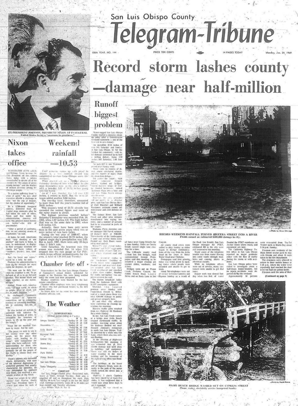
A year ago today, San Luis Obispo County was being drenched by one of its worst rainstorms in years, one that led to the wettest year in history here.
The forecast on Jan. 18, 1969 had been for “unsettled weather” in the northern portion of the state but nothing unusual for the central part.
Then the roof fell in.
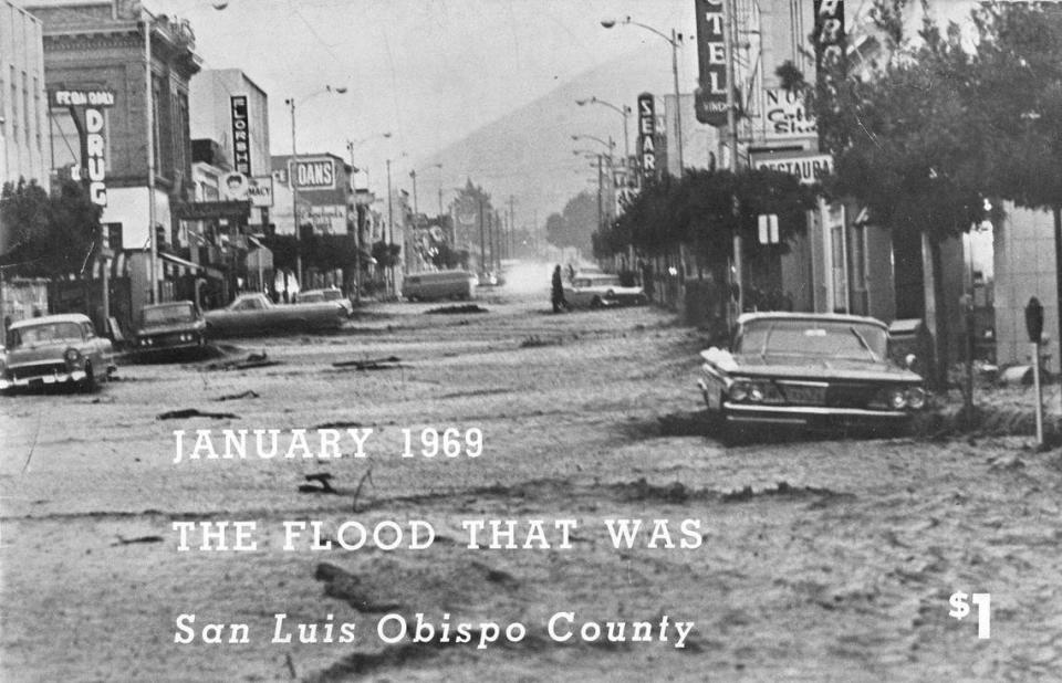
In four days, San Luis Obispo had 13.68 inches of rain. In the 18 days from Jan. 13 until the end of the month, a total of 24.63 inches fell.
That’s “unsettled” weather?
Well, blame the weatherman. Everyone does. But it won’t do you any good.
No matter how far science has progressed, man still can’t control the elements. He is learning more about them and what they can do, however.
San Luis Obispo County’s official forecast comes from the U.S. Weather Bureau at Santa Maria’s airport and while its meteorologists don’t claim infallibility, they usually don’t go too far wrong on their observations.
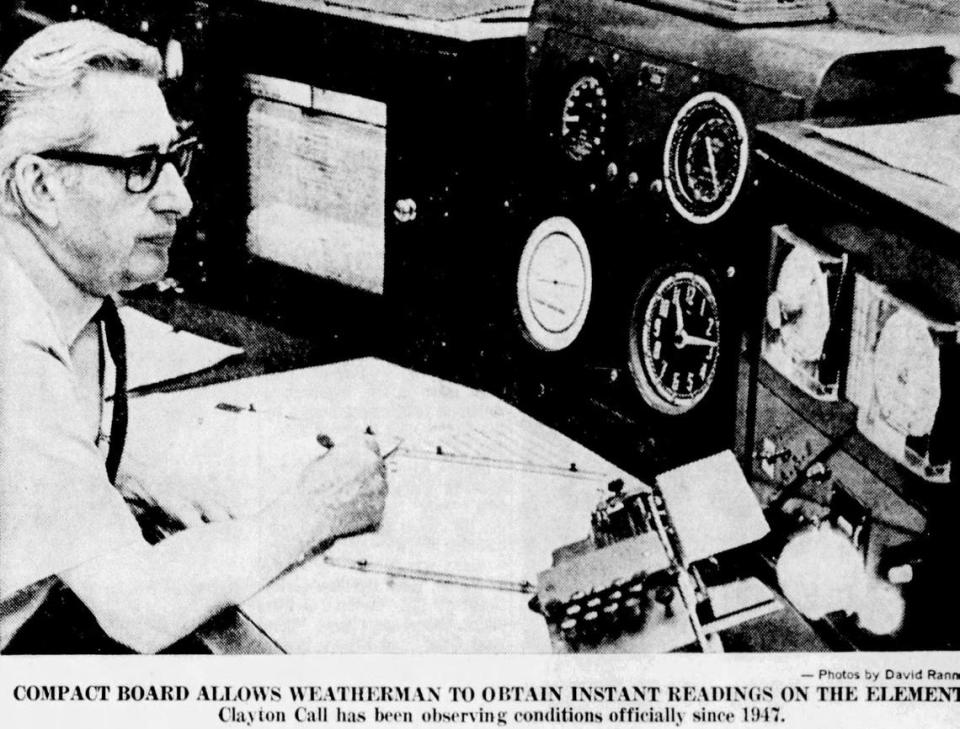
A couple of veterans in the business take care of the maps, gauges, thermometers and other instruments in the station. They are Bill Klien, who has nearly 20 years behind him, and Clayton Call, who began in 1947.
Their experienced eyes can’t see another deluge like last year’s.
“But we’re not saying it can’t happen, either,” says Call.
There are really few places in the United States which are eligible to issue official forecasts and Santa Maria isn’t one of them.
“Ours is adaptive forecasting,” Call said. “We’re not authorized to originate a forecast.
“We don’t claim our forecast is 100 percent accurate because some of it is based on our own observations. We assemble all the data we can through our instruments and mix it up with what weather patterns we have observed over the years and come up with what we feel is a reasonably good forecast.
“Our biggest help comes from the weather bureaus in San Francisco and Los Angeles. They’re fairly correct for their areas but we feel we know our own district or area best and we modify the forecast to suit our purposes.”
Occupying a portion of one airport building, the Santa Maria weather station is no great shakes as far as size and equipment are concerned. But it is adequate for its territory, which covers the Central Coast from Santa Barbara to Paso Robles.
Probably 50 percent of its time is devoted to aircraft, which rely heavily on weather information. Altimeter settings on a plane, for instance, are dependent largely on barometric pressures which the station supplies. The ceilometer, too, gives a pilot the correct cloud cover measurements.
The station’s wind gauges, so vital to flying, are placed in the middle of the runways to give the most accurate readings possible.
The station received ESSA satellite weather maps daily and dozens of other maps by computer.
“We used to draw all these ourselves,” said Call, pointing to tables full of machine-made maps. “Now they just roll out the computer.”
“The main information center for weather bureaus is at Silver Springs, Md. Weather data from all parts of the country is funneled in there, where it is refined and issued in map form.”
Klien or Call can give temperature, wind or rainfall readings any moment of the day because their gauges outside are hooked up with the main control board inside.
“We make our own adaptive forecast every day, but if conditions change we revise it,” Call said. “After one has been in a certain location a few years, he pretty well knows conditions. At least enough to help in a forecast.”
One of the most unanswerable questions put to the weathermen regards the length of a storm.
“So many people don’t want the rainfall overnight,” Call said. “They want the amount for the storm. Well, all storms aren’t continuous. They may break up two or three times. So do you call them separate storms or just one big one? We never know quite how to answer that one. A 10-day storm may have two or three dry days but it’s still part of a single mass.”
High and low pressure areas sometimes are confusing. Call explained, but there really isn’t much to remember. A low pressure indicates moisture and high pressure dry conditions.
“A high, or dry, pressure area off the coast can block a storm from coming inland,” Call said.
“It acts like a fortress. A storm can go to either side of it and often does.
“Eventually, though the high pressure area disintegrates and everything goes back to normal. Once it does, free flow is restored. If it should be holding up a big storm and then gives way suddenly, we’d get wet.
“That’s probably what happened last year.”

