El Reno 5 years later: Revisiting the fury of the largest tornado ever recorded
One of the most powerful tornadoes ever recorded in the United States barreled across southern Plains on May 31, 2013, devastating areas near El Reno, Oklahoma.
"The El Reno tornado is well-known to be the widest tornado on record," AccuWeather Senior Storm Warning Meteorologist John Lavin said.
The mammoth, 2.6-mile-wide twister also packed some of the most intense winds ever measured and capped off a week-long severe weather outbreak across the central United States.
The days leading up to the tornado outbreak
The El Reno tornado occurred on the last day of a tornado outbreak that started on May 26, 2013, and lasted through May 31, 2013.
During this time, there were over 140 reports of tornadoes from Colorado through New York; however, a majority of the reports were focused on the central U.S., according to the Storm Prediction Center (SPC).
This tornado outbreak was also right on the heels of the violent EF5 tornado that devastated Moore, Oklahoma, on May 20, 2013, which caused 24 fatalities and flatted over 300 homes.
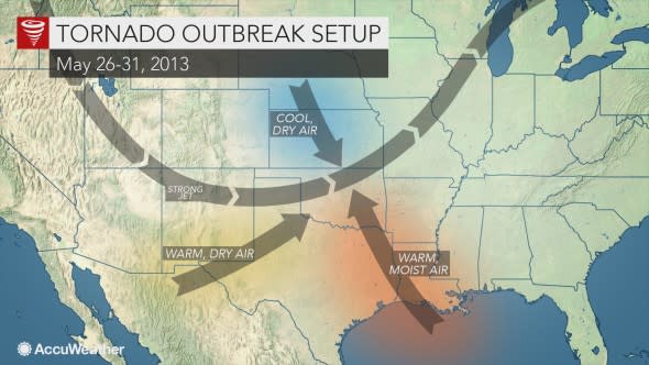
By the morning of May 31, 2013, it was becoming evident that the ingredients were coming together for another deadly tornado outbreak in central Oklahoma.
When the SPC issued their daily thunderstorm outlook, they highlighted the potential for significant tornadoes in central Oklahoma late that afternoon into the early evening.
The potential for life-threatening tornadoes prompted some emergency managers in the region to email schools, hospitals and businesses that morning to ensure that they had a plan in place when severe weather was approaching.
Evolution of the record-breaking tornado
The first severe storms of the day began to fire in the late afternoon with the El Reno tornado touching down at 6:03 p.m. CDT.
After being on the ground for just over 15 minutes, the twister rapidly intensified, eventually becoming 2.6 miles wide, making it the widest tornado ever recorded. Before this, the widest tornado had been the 2004 Hallam tornado which peaked at 2.5 miles wide in Nebraska.
In addition to being exceptionally large, the tornado had an unusual behavior, fluctuating in speed and direction, making its motion unpredictable to even the most experienced meteorologists and storm chasers.
"At first, it took an east to southeast movement at 30-40 mph, but later on, it suddenly took a rapid turn to the north, moving at 50 mph," Lavin said.
"Then once the tornado moved north, it slowed down and only moved at 10 mph before finally dissipating," Lavin added.
"These changes in movement and speed were contributing factors that caught many [people] off guard."
The tornado killed eight people and injured 151 others before it lifted at 6:43 p.m. CDT. It was on the ground for 16.2 miles and left behind a scar on the ground large enough to be seen from space.
All eight people that died that day were in their vehicles when they were caught in the tornado. This included three well-known storm chasers: Tim Samaras, Paul Samaras and Carl Young.
Quiz Maker - powered by Riddle
The tornado hit the El Reno area around the same time as the evening commute, meaning that more people were on the highway when the large tornado crossed Interstate 40 west of Oklahoma City.
In addition to the rush hour traffic, some people in the area took to the roads to try to outrun the storm instead of seeking shelter.
"The public felt the fear induced by the May 20 [Moore tornado] event and led people to take actions on May 31 they would not normally take," the National Weather Service (NWS) said in an assessment of the tornado outbreak.
"Many members of the public, as well as some emergency managers and other weather-savvy experts, mentioned that, given the fear they felt after the storms on May 19-20, this advice to evacuate overrode their typical emergency plans and advice about sheltering in place," the NWS said.
"The atypical response of many residents evacuating from the tornadoes rather than following shelter plans led to the traffic jams and accidents," they added.
"On May 31, slow-moving storms around rush hour, and the context of recent events, resulted in confusion, frustration and, sadly, more fatalities."
Flash flooding disaster unfolds following the historic tornado
The 2.6-mile-wide tornado nearly flattened buildings and flipped vehicles in its path, leading to approximately $35 million to $40 million in damages.
However, some of the immediate response and recovery efforts had to be delayed due to the persistent threat of severe weather into that night.
"This storm would go on to produce several other tornadoes in the Oklahoma City metro area, and a line of training supercells produced heavy rainfall and runoff that in turn caused historic flash flooding." the NWS said.
"Up to around 7 inches of rain fell in Oklahoma City, and 13 people died as a result of the flash flooding," Lavin added.
This was the deadliest flash flooding event in central Oklahoma since April 3, 1934, when flooding along the Washita River caused 17 fatalities.
In the days following the monster tornado, the NWS announced that it was an EF5, the highest possible rating for a tornado. However, three months after the storm, it was downgraded to an EF3.
The Enhanced Fujita Scale is a rating system for tornadoes that is based on wind damage. The severity of the damage indicates how powerful the tornado was when it hit.
One of the mobile Doppler radars near the tornado measured maximum winds near the ground of 296 mph, the second-highest ever measured on Earth following the 1999 Bridge Creek-Moore tornado.
However, the tornado was at its strongest when it was tracking across open land and no damage was found that supported winds that high, and thus it was given a final rating of an EF3.
While some may disagree on the final rating, many have looked back and have learned from that terrifying day.
New storm shelters were opened across El Reno two years later that were equipped with auxiliary power, bathrooms and water pumps in case of flooding.
"I'll be surprised if we couldn't fit the entire population of El Reno in just our storm shelters alone," Craig McVay, El Reno Schools Superintendent, told News9.
The NWS also examined their use of social media throughout that day and identified ways to better use platforms, such as Facebook and Twitter, to relay crucial information to the public during future severe weather outbreaks.