El Nino stubbornly clings to life but hurricane-fueling La Nina pattern still looms

COLLEGE PARK, Md. – El Niño is still here … barely.
Tropical Pacific Ocean conditions are still clinging to some above-average warmth in critical parts of the eastern and central regions that just meet the minimum threshold of at least 0.5 degrees Celsius (0.9 degrees Fahrenheit) for maintaining an El Niño Advisory, NOAA announced in its monthly update Thursday.
But El Niño's days are still numbered, NOAA predicts. A majority of forecast models indicate continued cooling of the waters in that area of the Pacific, with a 79% chance El Niño conditions will end within the next month.
It's a declaration already made by some other national meteorology agencies around the globe, including Australia, which uses different reporting methods than NOAA to already declare El Niño over last month.
When neither La Niña nor El Niño are in control of what's known as the El Niño Southern Oscillation (ENSO) pattern, it is considered to be a neutral status, which is sometimes referred to as La Nada.
NOAA says despite the lingering ocean warmth, the atmosphere in the tropical Pacific continues to show signs of fading El Niño influence and is transitioning to neutral status.
And still likely looming on the horizon: A flip to the opposite La Niña pattern, which could enhance the upcoming hurricane season.
AUSTRALIA DECLARES EL NINO OVER IN TROPICAL PACIFIC
An exit out of El Niño into a neutral status would likely not mean any immediate weather changes for North America, but the FOX Forecast Center will be watching for impacts during the upcoming summer and hurricane season.
Meteorological summer begins on June 1, the same date as the start of the year’s tropical cyclone season.
Neutral years have run the gamut from just a handful of tropical systems to being among the most active on record, but seasons under a neutral regime typically are more impactful than those that occur during an El Niño.
On the temperature front, all occurrences of neutral events over the last two decades have produced summers that had above-average or well-above-average temperatures.
The neutral-ENSO summer of 2019 was the hottest season on record for North America, with record heat experienced along both the West and East coasts.
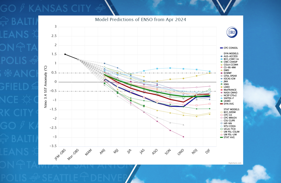
While neutral status is on deck, it doesn't appear it'll be too long before the tropical Pacific cools straight into a La Niña pattern.
NOAA believes there is a 69% chance water temperatures will cool to greater than -0.5 degrees Celsius by late summer with an 83% chance by autumn.
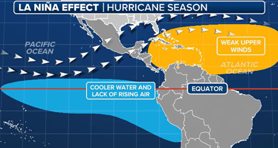
However, experts at Colorado State University and many others consider the impending La Niña to play a significant role in intensifying the 2024 hurricane season.
La Niña patterns in the summers and early autumn tend to weaken upper-level winds in the Atlantic Ocean basin that would normally contribute to shearing apart budding storms.
Researchers said they expect 23 named storms to form in 2024, with 11 that could reach hurricane status. Five of the 11 hurricanes are expected to reach major hurricane status with winds of at least 115 mph.
2024 ATLANTIC HURRICANE SEASON COULD BE AMONG MOST ACTIVE ON RECORD, EXPERTS PREDICT
But even with or without La Niña, which aids hurricane formation with favorable upper-level patterns, a year-plus-long stretch of record ocean temperatures in the Atlantic Ocean is also fueling fears of a very active hurricane season on the horizon.
ATLANTIC OCEAN'S RECORD WARM STREAK ENDS AFTER 421 DAYS
As we exit hurricane season at the end of the year and march toward fall and winter, the La Niña phase typically correlates to dry weather in the southern U.S. and cooler, wetter weather in the Pacific Northwest and parts of the North.
It would be the opposite of what we’ve generally seen this past El Niño winter.
California took the brunt of several storms – many of them atmospheric river storms – leaving much of the state well above average for precipitation.
As the strong Pacific jet stream persistently hugged the South, several rainstorms have pushed through Texas and the Gulf Coast. Florida suffered through one of its cloudiest December-January periods on record, according to data from Alaska climatologist Brian Brettschneider.
Meanwhile, aside from a strong polar-vortex-fed arctic outbreak in mid-January, it was a very mild winter across the nation's northern tier.
Minneapolis had just 29.5 inches of snow – nearly 22 inches below average – and people were able to play golf and install swimming pools during the winter in a region more well-known for subzero temperatures and snowstorms.
Swimming and golf may be relegated back to more of a summertime event if La Nina gets a hold of next winter.
NOAA's next regular monthly update on the ENSO pattern is scheduled for June 13.
Original article source: El Nino stubbornly clings to life but hurricane-fueling La Nina pattern still looms

