Early week storm may be strongest yet this season in northwestern US
The storm sweeping across the northwestern United States through Tuesday will pack a big punch in Washington and Oregon.
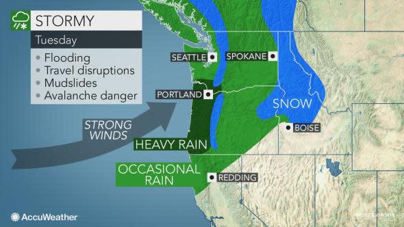
This latest storm may prove to be the most impactful of the season so far in terms of rainfall, snow and wind for the Pacific Northwest.
"Pretty much all of western Washington and western Oregon will have the risk of flooding in low-lying and poor drainage areas and also the threat for flooding from rising creeks, streams and rivers," said AccuWeather Senior Meteorologist Dave Houk.
Rainfall totals of 3-6 inches are possible at the coast, in the coastal ranges and into the Cascades, with 1-3 inches for the Interstate-5 corridor and inland valleys.
People traveling along I-5 from Medford to Eugene, Salem and Portland, Oregon; and toward Olympia, Tacoma and Seattle, Washington, will want to make sure windshield wipers are in good working order and tires do not have worn tread.
In addition to facing reduced visibility, motorists can encounter ponding of water and flooded, closed roads.
Never make an attempt to drive through floodwaters, as the water can be deeper and moving faster than it appears. Instead, turn around and find a safer, alternate route.
While the heaviest snow will fall above 3,000 feet in the Washington Cascades, snow can still lead to slick conditions across Snoqualmie Pass east of Seattle on I-90 through Tuesday.
Where precipitation remains all snow for the duration of the event in the highest elevations of the Washington Cascades, over a foot of snow can accumulate.
The combination of heavy snow, wind and fluctuating snow levels will result in an increased threat for avalanches across the Washington Cascades through Tuesday.
Gusty winds threaten to cause additional travel difficulties, tree damage and power outages.
The highest gusts will be along the coast where winds exceeding 70 mph into Tuesday morning can down trees and disrupt electricity.
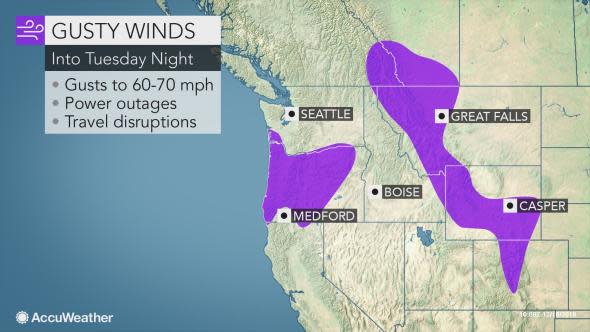
"The threat for power outages will extend eastward to include the I-5 corridor, though highest peak gusts there will be closer to 50 mph," Houk said.
Any trees that have been weakened by recent rain and wind events will be more susceptible to being toppled over in the gusty weather.
The high winds will spread inland across the Northwest from Tuesday into Wednesday.
Snow will also spread into the Bitterroot Mountains and northern Rockies during this time frame, and with the gusty winds, will create reductions in visibility.
Motorists, especially those driving high-profile vehicles, can face significant crosswinds along stretches of U.S. Route 101 and interstates 5, 15, 84 and 90.
Outdoor furniture, holiday decorations and trash cans should be secured or stowed away until the windiest weather has passed.
Download the AccuWeather app to see the exact impacts from the storm for your area.
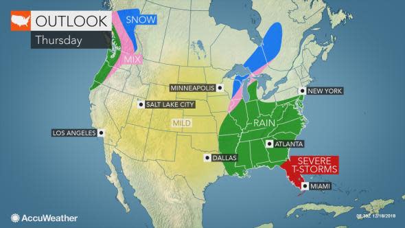
The region will have little time to regroup itself when the storm exits around midweek, as the next system will be knocking on the doorstep.
However, much less rain, wind and snow is expected with the next system, which will arrive on Thursday.
