Drenching, locally severe storms to pave way for cooler air to invade northeastern US this week
Prior to the arrival of much cooler and less humid air at midweek, thunderstorms packing torrential downpours and locally damaging winds will rattle the northeastern United States into Tuesday evening.
Temperatures in Washington, D.C., Baltimore and Philadelphia and Harrisburg, Pennsylvania, all soared into the 90s F as AccuWeather RealFeel® Temperatures surged past 100 degrees Fahrenheit in many locations on Monday.
With plenty of moisture available in the atmosphere, thunderstorms ahead of the cool push have the potential to result in downpours intense enough to cause flash flooding, according to AccuWeather Meteorologist Kyle Elliott.
In this type of pattern, rainfall amounts could exceed 2 inches per hour, which is enough to overwhelm storm drains and small streams and flood neighboring roads, homes and businesses.
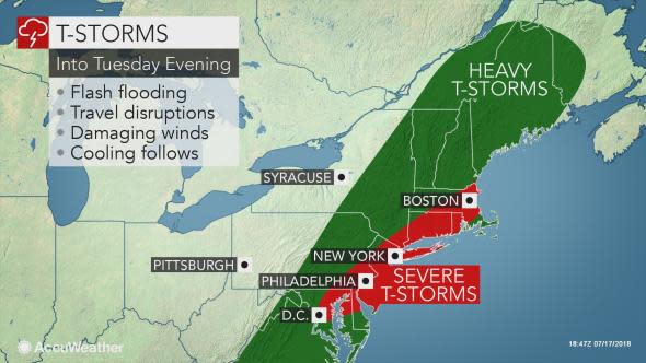
Some of the storms, especially those over southern New England, have the potential to produce damaging wind gusts that can knock down tree limbs and cause sporadic power outages.
A couple of the strongest storms have the potential to produce a brief tornado in the coastal mid-Atlantic and in southeastern New England.
Motorists and airline passengers should be prepared for major delays during their afternoon and evening commutes. The storms will hit many of the major cities from Boston to New York City, Philadelphia and Washington, D.C.
People spending time on the southern New England and mid-Atlantic beaches may have their evening activities disrupted.
The 89th MLB All-Star Game is scheduled for 8 p.m. Tuesday night in Washington, D.C., at Nationals Park.
"There is a risk of showers and thunderstorms in Washington, D.C., into Tuesday evening," AccuWeather Senior Meteorologist Dave Dombek said.
This would likely dampen any pregame ceremonies prior to the game. Fans heading to Nationals Park should bring an umbrella or rain jacket as they head to the stadium.
However, Dombek said the storms will likely have ended or will be getting ready to move out of the area by 8 p.m.
Any non-flooding rainfall will benefit the abnormally dry to moderate drought conditions occurring in much of New York state, New England and parts of the mid-Atlantic.
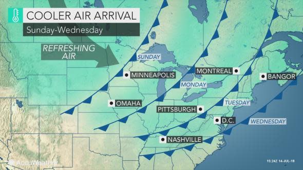
Comfortable conditions will return for Wednesday and Thursday, according to Elliott.
Temperatures will lower into the 70s across interior areas and 80s along the coast, accompanied by lower humidity and plenty of sunshine.
The respite from the heat and return of dry weather will give people an opportunity to turn off fans and air conditioners, head to the beach, pool or lake and exercise outdoors more comfortably.
"However, we will be monitoring the potential for another storm system to bring wet weather chances back to the mid-Atlantic and Northeast by this weekend," Elliott said.
AccuWeather Lead Long-Range Meteorologist Paul Pastelok expects waves of moisture to surge northward along the East coast on a regular basis during much of the second half of July, bringing additional risks of flooding.

Do you think rain is in the forecast? Make your prediction now and play Forecaster Challenge.
