Drenching rain, fog may foil plans in southern and eastern US into Sunday night
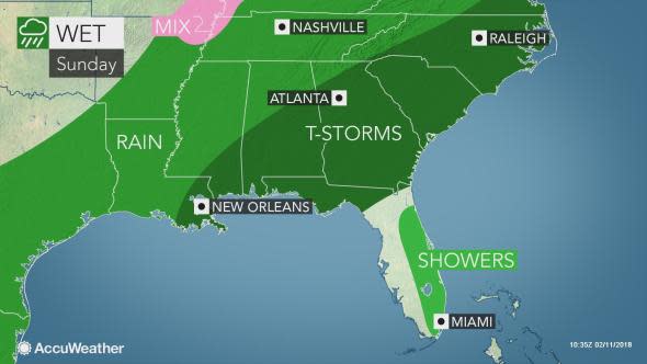
Episodes of rain will put a damper on Sunday plans from the Gulf Coast to New England, while fog may slow travel in parts of the eastern United States.
A stripe of snow will extend across the Great Lakes. However, a storm will track far enough to the north and west to allow mild air to spread from the Deep South to much of the Ohio Valley and Northeast.
Heavy rain to the south lead to flooding across eastern Kentucky and southern West Virginia on Saturday night and Sunday. A small mudslide caused a section of US 52 to be closed near Delbartion, West Virginia on Sunday morning, according to the Department of Highways.

Temperatures will climb into the 30s, 40s and 50s F across the north and into the 60s and 70s across the south. With the higher temperatures and moisture in the air, it may feel more like spring rather than the middle of winter.
The action of mild, moist air flowing over cold ground and/or snowcover will produce widespread misty conditions.
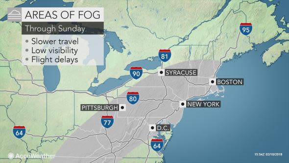
In areas from the Appalachians and Piedmont to New England, fog and low clouds may be extensive enough to lead to airline delays.
Delays related to poor visibility are possible in Atlanta, Charlotte, North Carolina, Washington, D.C., Baltimore, Philadelphia, New York City and Boston.
The milder weather will allow property owners to clean snow and ice off of their sidewalks and driveways.
Motorists are reminded that leaving snow and ice on vehicles, including the roof of truck trailers, while driving is dangerous and subject to a stiff fine in some states. This snow may suddenly slide forward during deceleration and obstruct visibility. Snow on the roof of a vehicle may become a projectile and cause an accident.

Widespread flooding is not anticipated in the Northeast and in areas east of the Appalachians in the South. In these areas, a few brief incidents of urban flooding may occur, where downpours develop and persist.
"The area from the central Gulf coast to the Tennessee Valley and southern Appalachians may receive enough rain to lead to flash and small stream flooding," according to AccuWeather Senior Meteorologist Brett Anderson.
"In this same area, minor river flooding is also a possibility in low-lying, unprotected locations," Anderson said.
From 1-4 inches of rain is forecast in this swath through Sunday night.
Parts of the Eastern and Southern states are experiencing long-term, abnormally dry to drought conditions. So the rain may be beneficial in terms of putting water into reservoirs.
Thunderstorms will accompany the rain in the Southern states. Most of the storms will be unremarkable. However, a few storms that erupt over the central and eastern Gulf Coast may briefly turn severe on Sunday. An isolated tornado is possible near the coast.
"Just enough chilly air may return to bring a period of wet snow or freezing rain to some of the western slopes of the Appalachians during Sunday night," Anderson said.
However, a big blast of arctic air is not anticipated to return any time soon.
Beyond this weekend, mild and damp conditions are likely to remain in the southeastern part of the nation into at least the first part of the week.
