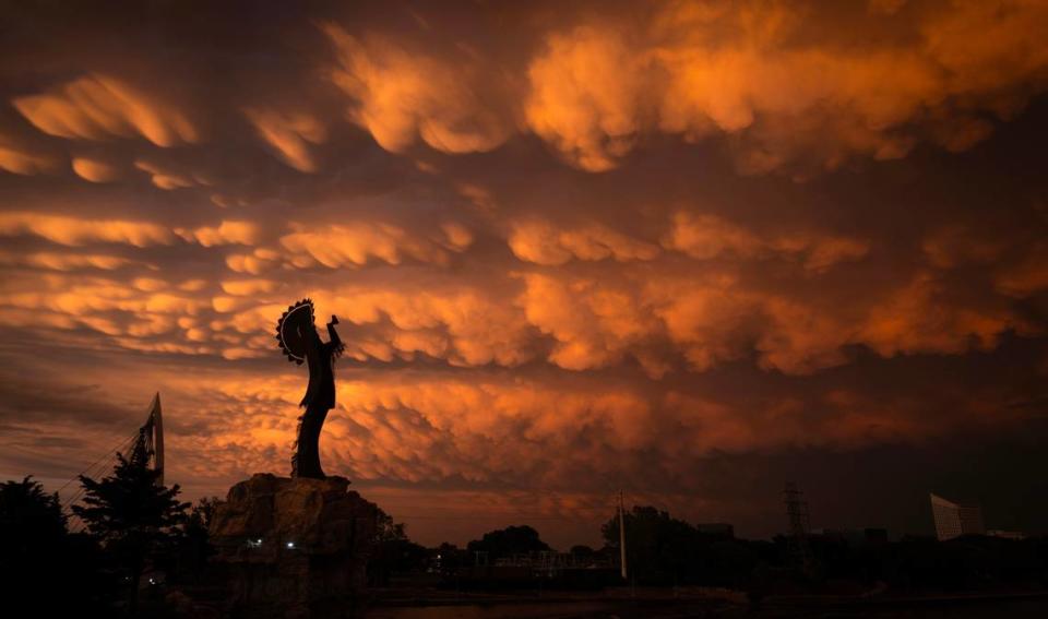
Dramatic clouds overtake Wichita skies — and social media. What were the formations?
If you looked up at the Wichita sky Tuesday night around sunset, dramatic cloud formations probably caught your eye.
For those who missed the evening cloud cover, chances are good you can catch a glimpse online, as social media was abuzz Wednesday morning with photos.
See photos of amazing cloud formations over Wichita after Tuesday’s storms
The formations that could be seen Tuesday are Mammatus clouds, which are formed in tall thunderstorms.
According to the University Corporation for Atmospheric Research Center for Science Education, Mammatus clouds are “pouches of clouds that hang underneath the base of a cloud.” These clouds often follow cumulonimbus clouds, which produce thunderstorms.
According to Robb Lawson, a forecaster with the National Weather Service Wichita office, such formations are common in the area.
“Anytime you have a tall thunderstorm, you have a chance for them,” Lawson said of Mammatus clouds.
These clouds appeared after an evening of thunderstorms Tuesday. Wichita was under a tornado watch through the evening and saw hail, as well as strong wind gusts.
Leon, Rosalia, Latham, Winfield, Akron, Wilmot, Caney, Sedan and Peru all saw tornado warnings. A tornado touched down near Westmoreland and destroyed 22 homes. One death from that tornado has been confirmed as of Wednesday morning.
While Mammatus clouds like those seen Tuesday over Wichita are common, how dramatic they are varies from storm to storm.
“They come in different varieties, some are more dramatic than others. We even had some four days ago, they just weren’t that dramatic. But we get them quite often here,” Lawson said.
When’s the next time Wichita will see a storm?
The NWS says south-central and central Kansas could still see scattered showers and storms through mid-morning Wednesday. Showers and thunderstorms are expected to continue throughout this week.
Here’s this week’s forecast in Wichita, from the NWS:
Wednesday: A 30% chance of thunderstorms with a high around 74 degrees Fahrenheit. A 50% chance of showers and thunderstorms after 4 a.m. and a low around 61.
Thursday: Showers and thunderstorms after 7 a.m. and a high around 73 degrees. A 30% of showers and thunderstorms after 1 a.m. and a low of 50.
Friday: A 20% chances of showers and thunderstorms in the afternoon and a high around 73. A low near 54 with chances of thunderstorms after 1 a.m.
Saturday: A 40% chance of thunderstorms before 1 p.m. with a high around 70 degrees. A 20% chance of thunderstorms after 1 a.m. and a low around 52.
Sunday: A 40% chance of thunderstorms and a high around 70 degrees. A low near 59 with a 30% chance of thunderstorms after 1 a.m.
It’s important to have a severe weather plan in place in case of severe thunderstorms and tornadoes. Here are some steps from the U.S. Centers for Disease Control and Prevention:
Know what safe space to go to in your home.
Have a list of important information, like emergency phone numbers, handy.
Keep emergency supplies in reach.
Keep a first aid kit available.
Keep extra food and water.

