Don't look now, but another monster hurricane is brewing in the Atlantic

The floodwaters from Hurricane Harvey have yet to recede in Texas and Louisiana, but weather forecasters are already warily eyeing another storm that is rapidly intensifying in the tropical Atlantic Ocean — and could threaten the U.S. next week.
Hurricane Irma, which was upgraded to a Category 3 storm on Thursday afternoon — and is likely to become a high-end Category 4 or 5 beast of a storm — is moving west over the open ocean about 840 miles west of the Cabo Verde Islands. On its current track, Irma is forecast to begin affecting the Leeward Islands on Tuesday, with Puerto Rico, the Bahamas, and possibly the mainland U.S. in its sights after that.
SEE ALSO: Rescue efforts are underway in Houston
There are a few factors that worry hurricane forecasters more about this storm when compared to the myriad other tropical storms and hurricanes that tend to form in the Atlantic.
'Going beyond the cone' by using model guidance to give that next heads up on #Irma. h/t @GregPostel @WxDiz pic.twitter.com/VLmt03HYXt
— Maria LaRosa☀️ (@twcMariaLaRosa) August 31, 2017
HWRF going full blown Category 5 beast as #Irma tracks toward the Windward Islands. pic.twitter.com/CDs6NkUh8F
— Eric Fisher (@ericfisher) August 31, 2017
First, it's a so-called Cape Verde storm, having formed off the west coast of Africa. These storms tend to be the ones that go on to affect the U.S., after gathering strength for many days during their march across the ocean. For example, Hurricane Andrew, which was the most recent Category 5 storm to hit the U.S. in 1992, was a Cape Verde-type storm.
Because they begin at a relatively low latitude and move west rather than northwest, it can be harder for upper level winds blowing across North America to pick up and steer these types of storms away from the U.S. coast.
Still, it's common for a hurricane like Irma to near the East Coast but then recurve away, after hitting a force field in the form of westerly winds at the upper levels of the atmosphere. Such winds can protect the East Coast from a landfalling hurricane.
It's the hurricanes that fail to recurve, and instead move into or up the eastern seaboard, or even pass into the Gulf of Mexico, that are the most dangerous for the U.S. And computer models are keeping these scenarios very much in play, at least for now.
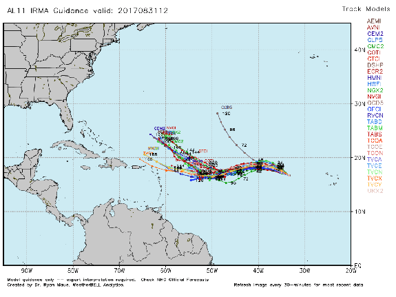
Image: weatherbell
It is too early to tell which path lies ahead for Hurricane Irma, but it has already become a "major hurricane," of Category 3 intensity or greater, and has a chance to get even stronger during its westward march over Labor Day weekend and into the first week of September.
Computer model guidance suggests that a U.S. landfall is within the realm of possibility, with a turn out into the North Atlantic also still on the table.
Conditions for the next few days are ripe for Irma to maintain its intensity, with little vertical wind shear and relatively warm waters. However, dry air nearby the storm could cause minor weakening to occur, before it moves into a more favorable environment for intensification in a few days.
The best advice for now is for anyone with interests along the East Coast in particular to start paying attention to Irma and its track and intensity forecasts, recognizing that forecasts this far in advance — about a week to 10 days — have a considerable amount of uncertainty associated with them.
The track forecast for Hurricane Irma will depend on how the weather pattern develops across North America, and that is going to be influenced by yet another tropical weather system, this time a typhoon that is spinning off into the North Pacific Ocean.
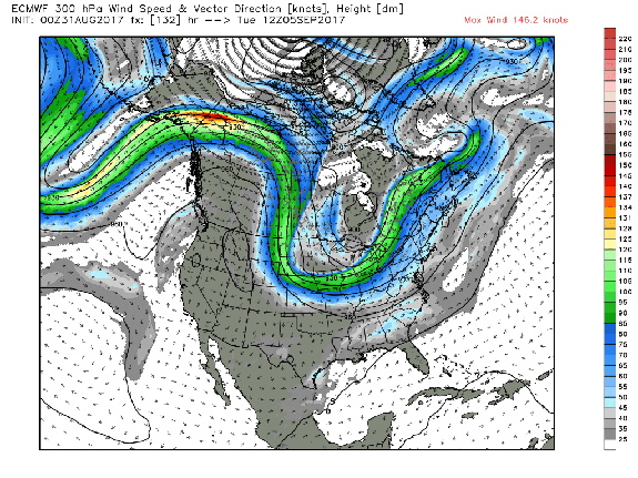
Image: weatherbell
Studies have shown that when powerful typhoons recurve away from Japan, into the North Central Pacific, they can energize the highway of swiftly flowing winds at high altitudes, popularly known as the jet stream, and lead to a more active weather pattern thousands of miles downstream.
For the jet stream, the storms can function as an injection of steroids, causing it to amplify and contort itself into large north-south undulations. These waves, known to meteorologists as ridges and troughs, get carried downstream like ripples in a pond, affecting weather in Alaska and the continental U.S.
What this means is that the weather pattern across the U.S. next week will probably feature a wavy jet stream. How this jet stream pattern interacts with Irma will be a big question that forecasters hope to answer, since an East Coast trough could help to sweep the storm out to sea.
While it's possible the storm will eventually enter the Gulf of Mexico, one thing is for sure: Hurricane Irma is not an immediate threat to the Houston area, where the focus is squarely on search and rescue as well as recovery efforts.
This article has been updated to reflect the latest forecast information on Sept. 1, 2017.
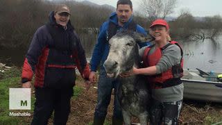
WATCH: Smiling rescued donkey is so happy to be back on solid ground