'Difficult to impossible' travel: 1-2 feet of lake-effect snow to paste Great Lakes region
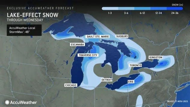
It's lake-effect snow season near the Great Lakes, and the first significant event of the year is forecast to dump as much as 1-2 feet in some areas, leading to what the National Weather Service calls "difficult to impossible" travel.
"Moderate to heavy lake-effect snow is expected today into Wednesday morning downwind of the Great Lakes," the weather service said Monday.
The worst of the weather is expected Monday night: "The lake-effect snow is expected to reach peak intensity across the entire Great Lakes from Monday afternoon through Tuesday morning," AccuWeather meteorologist Jake Sojda said.
The weather service warned that "if traveling, be prepared for rapidly changing road conditions and visibilities."
Most of the heavy snow should stay closer to the lakes, and parts of northern Michigan, northwestern Pennsylvania and northern New York are the most likely targets for feet of snow, according to Accuweather.
The weather service said the snow is forecast to remain south of the Buffalo metro area.
What is lake-effect snow?
Lake-effect snow, which can last for only a few minutes to several days, develops from narrow bands of clouds that form when cold, dry arctic air passes over a large, relatively mild lake.
These snows typically occur only in the fall or early winter, before the lakes freeze over. (But if the lakes don't freeze, lake-effect snow can occur throughout the winter and into the spring.)
Wind direction is also key to determine which areas will receive lake-effect snow. Heavy snow may be falling in one spot, while the sun may be shining just a mile or two away in either direction.
One of the biggest lake-effect snowfall events on record hammered areas near Buffalo, New York: 5 feet of snow in a span of two days in November 2014, AccuWeather said.
Will there be a white Christmas in 2023? Forecasters have some predictions.
Dangerous snow squalls also possible
Snow squalls well away from the Great Lakes are also possible into Tuesday evening, AccuWeather senior meteorologist Alex Sosnowski said.
"Snow squalls are especially dangerous as they pass over high speed, busy highways, such as Interstates 79, 80 and 81 in the region, where the volume of traffic may prevent motorists from seeing the squalls coming in advance," he said.
Squalls can occur when a strong Arctic front rolls through a region and are comparable to quick-moving summer rain showers and thunderstorms.
Snow squalls have caused massive and deadly chain-reaction highway pileups in recent winters because of their brief but intense snowfall rates, which can drop visibility at a moment's notice while slickening roads.
Chain-reaction accidents can kill or injure dozens of people each winter and can wreck hundreds or even thousands of cars and trucks.
Cold season is here: Chill spilling into the US this week with below-average temperatures for most
Coast-to-coast cold taking hold
While snow will be the primary weather threat around the Great Lakes, below-average temperatures will continue to be the main story across much of the nation this week.
"Highs Tuesday will be in the 30s and 40s for New England, the mid-Atlantic, and even into the Carolinas, with 50s for the Southeast and Gulf Coast/north Florida," the weather service said. "Chilly highs in the 20s and 30s are expected for the Great Lakes/Midwest with 30s and 40s from the central Plains into the middle Mississippi and Ohio Valleys. Highs will be in the 50s for Texas and the lower Mississippi Valley."
These temperatures are about 10-20 degrees below average for this time of year.
The West will also see unusually cold weather. In portions of California, a freeze warning is in effect until Thursday. "Frost and freeze conditions will kill crops, other sensitive vegetation and possibly damage unprotected outdoor plumbing," the weather service warned. "Temperatures can be dangerous to unsheltered or vulnerable pets and people."
This article originally appeared on USA TODAY: Lake-effect snow weather event to dump 1-2 feet near Great Lakes

