Denver weather: Mild Saturday with clouds, rain and snow coming Sunday
- Oops!Something went wrong.Please try again later.
UPDATE: Sunday is a Pinpoint Weather Alert Day in the Foothills and Palmer Divide due to snow and rain in the evening forecast.
DENVER (KDVR) — The above-average temperatures are forecasted to continue Saturday with highs in the middle to upper 60s. An isolated shower or two isn’t out of the question in the late afternoon to early evening hours, but most of Denver will remain dry.
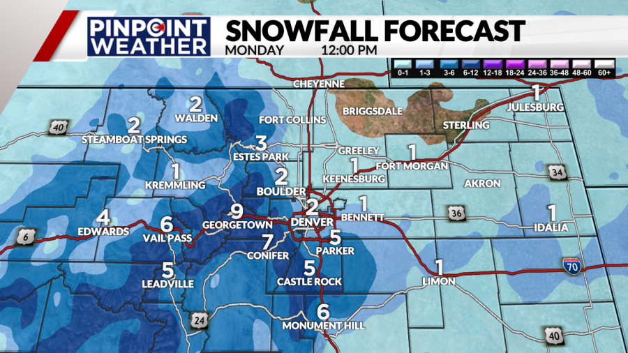
Denver weather: Where, when and how much snow to expect Sunday

The Pinpoint Weather team, Colorado’s Most Accurate Forecast, is tracking possible accumulation of heavy wet snow. The storm track is still in question and will impact final totals in the coming days. So, the totals shown here could change.
Weather today: Partly cloudy and mild, breezy
We’ll kick off the weekend with very mild temperatures across Colorado. Highs will make their way into the upper 60s nearing 70 degrees, with some readings across the eastern plains in the lower 70s.

Clouds will increase this afternoon ahead of an isolated shower or two. Denver could also see gusts up to 20 mph at times along the Front Range.
Weather tonight: Slight chance rain and mostly cloudy
Temperatures remain above average overnight as lows sink into the upper 30s nearing 40 degrees. Winds will be out of the south from 5-10 mph, ensuring warmer-than-normal temperatures. Denver could see gusts up to 25 mph during the evening hours along with a chance of rain showers.

Looking ahead: Pinpoint Weather Alert Day
A Pinpoint Weather Alert Day has been issued for Sunday evening due to snow and rain in the forecast for the Foothills and Palmer Divide.
A Pinpoint Weather Alert Day has been issued for Sunday due to snow and rain in the forecast for the Foothills and Palmer Divide. A Pinpoint Weather Alert Day has been issued for Sunday due to snow and rain in the forecast for the Foothills and Palmer Divide. A Pinpoint Weather Alert Day has been issued for Sunday due to snow and rain in the forecast for the Foothills and Palmer Divide.
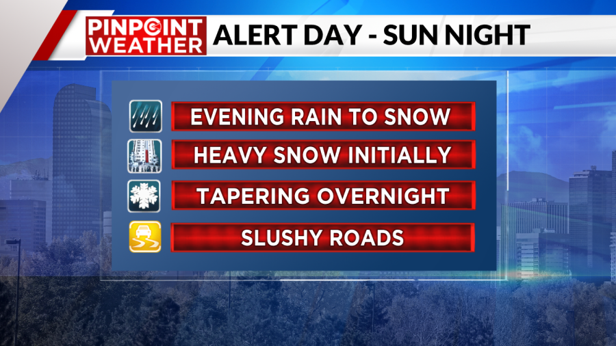

The Pinpoint Weather team is forecasting rain showers to develop early on Sunday. There could even be some thunderstorms on the eastern plains during the afternoon which could produce hail.
A cold front arrives later on Sunday and will change from rain to snow. Wind will pick up around this time.
Snow will be heaviest in the evening hours and snow will taper after a few hours ending by 1 or 2 a.m. Monday.
The weather will turn windy with gusts out of the north up to 30 mph. There could be some slick areas on roads especially west of Denver into the Foothills and south of the city across the Palmer Divide.

There could be an isolated shower drifting off the mountains on Tuesday. Otherwise, the area will be drying out and warming back into the mild 60s by midweek. The next chance for rain showers looks to arrive by the end of next week.
For the latest news, weather, sports, and streaming video, head to FOX31 Denver.

