How deep are Lake Shasta, Lake Oroville, 5 other popular California reservoirs?
After a wet winter and heavy snowmelt, North State lakes are brimming. But how far down does that water go before you hit bottom?
Reporting lake depth is tricky, according to Stewart Denham at the U.S. Forest Service's Shasta Lake Ranger Station #58. Depths are "a moving target. Just as the shoreline changes due to slides, the depth can change due to many things."
That could explain why reliable information about the depths to which most North State lakes go isn't easily available online, or contradicts itself, forest and recreation officials said.
Another factor is cost, Denham said. "It's very expensive to chart the underwater" topographically, so the government agencies don't do it "very often," he said, but it does happen.
At 1,645 feet, Lake Tahoe is the deepest lake in California. That’s the vertical equivalent of 4.6 football fields, or a third of a mile.
If you’ve ever wondered how deep those lakes on which you swim and boat really are, here’s a list of seven of the North State’s favorite recreation spots and to what depths they go.
Lake Oroville: 695 feet
The state’s second-largest reservoir, Lake Oroville, is 65 miles southeast of Red Bluff in Butte County. Its deepest point is next to the Oroville Dam in the southern part of the lake, where waters plummet 695 feet, according to staff at Lake Oroville State Recreation Area.
That’s 25 feet shy of two football fields lined up lengthwise (each 360 feet long), and 90 feet deeper than Seattle’s Space Needle is tall.
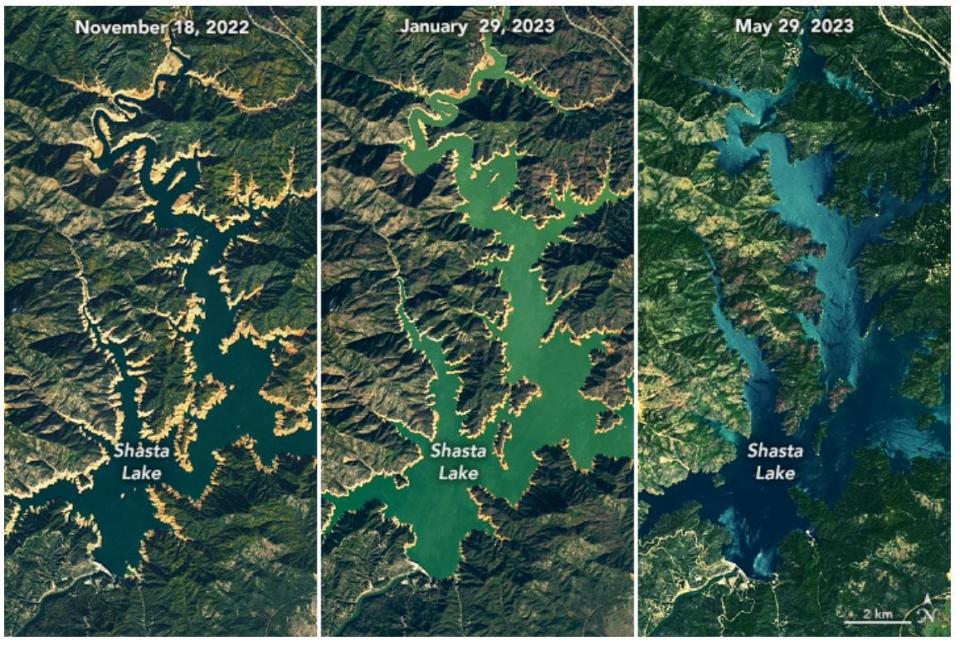
Lake Shasta: 517-522 feet
Nine miles north of Redding, Lake Shasta is California’s largest reservoir and the largest man-made lake, according to Donald Bader at the U.S. Bureau of Reclamation. At its deepest point next to the dam, the lake reaches depths of 517 to 522 feet, according to the bureau.
That’s more than three times the horizontal length of an Olympic swimming pool (164 feet), and about 35 feet shorter than the Washington Monument.
Note to readers: If you enjoy the work we do here at the Redding Record Searchlight, please consider subscribing yourself or giving the gift of a subscription to someone you know.
Trinity Lake: 390 feet
Located about 12 miles northeast of Highway 299 at Weaverville, Trinity Lake’s waters plummet to 390 feet deep when the lake is full, according to Shasta-Trinity National Forest Public Affairs Officer Ruth Esperance.
That’s the equivalent of five tennis courts (each 78 feet) lined up lengthwise, 30 feet longer than a football field, and almost halfway up the 48-story Transamerica Pyramid in San Francisco.
A 2012 report by the U. S. Department of Agriculture said the lake dropped to 465 feet at that time: The equivalent of six tennis courts.
Whiskeytown Lake: 264 feet
Nine miles west of downtown Redding, the lake at Whiskeytown National Recreation Area is a popular spot for sailing and swimming. Its deepest point is near the dam, which plummets 264 feet to the bottom, Whiskeytown Superintendent Josh Hoines said.
The top of an average 20-story building (250-260 feet) would vanish below its surface; the Taj Mahal would sit 24 feet below its surface.
Lake McCloud: 194 feet
Eleven miles south of Highway 89 at McCloud in Siskiyou County is the west shore of Lake McCloud, located in Shasta County. The lake’s deepest point, “just upstream of the dam,” is 194 feet deep when the lake is full, said Paul Moreno, spokesman for Pacific Gas and Electric utility company.
That’s about the height of a small, fully-grown redwood tree (200+ feet) and the vertical equivalent of the length of two basketball courts (each 94 feet).
Lake Siskiyou: 180-200 feet
Located about a 2.5-mile drive southeast of Mount Shasta, Lake Siskiyou reaches depths of up to 180 to 200 feet when full, according to the Box Canyon Flood Control Project.
That’s about the same as two basketball courts lined up lengthwise. If the Leaning Tower of Pisa was leaning at the same angle in the deepest point of Lake Siskiyou, it would barely break the surface, or stay 14 feet below it.
Lake Almanor: 100 feet
Bordering the southeastern edge of Chester in Plumas County, Lake Almanor reaches depths of 100 feet at its deepest point, when full, according to Moreno.
While it may sound shallow compared to other lakes on this list, its depth is greater than the horizontal length of a basketball court. Before it was demolished in 2008, Shea Stadium in Queens, New York would have sunk 14 feet below its surface.
Jessica Skropanic is a features reporter for the Record Searchlight/USA Today Network. She covers science, arts, social issues and news stories. Follow her on Twitter @RS_JSkropanic and on Facebook. Join Jessica in the Get Out! Nor Cal recreation Facebook group. To support and sustain this work, please subscribe today. Thank you.
This article originally appeared on Redding Record Searchlight: How deep are Lake Shasta, Lake Oroville, other California reservoirs?

