Death Valley’s temporary lake was measured by a NASA satellite. Here’s how big it got
SAN DIEGO (FOX 5/KUSI) — The driest place in North America had a lake big enough to kayak in this past winter, and NASA has released data on how big the rare lake actually got.
California’s Death Valley, the driest place in North America, has had a temporary lake forming in the Badwater Basin area since late 2023.
According to NASA’s Jet Propulsion Laboratory (JPL), record amounts of rainfall from storms over several weeks in February and March added to the temporary body of water dubbed “Lake Manly.”
Badwater Basin can be found at the bottom of Death Valley. At 282 feet below sea level, it is the lowest elevation in North America and is normally a dry salt flat.
Torrential rains in California make way for rare lake in Death Valley National Park
Death Valley National Park, which normally averages about two inches of rain per year, received 4.9 inches over the past six months, with the surrounding mountains receiving greater amounts of rain, the National Park Service reports, most notably from Hurricane Hilary in August and the atmospheric river storms in early February.
The shallow lake that formed after all that rainfall was open to kayaking for a short time, but has since closed to all boating after the water levels dropped, the National Park Service said in an update Friday. As the lake evaporates, it is now only a few inches deep and can only be accessed over rough, uneven salt and mud with no trail available.
Due to damage caused by people dragging watercrafts across the salt flats, the lake is now closed to all boating — kayaks, paddleboards, canoes, pool floats and more.
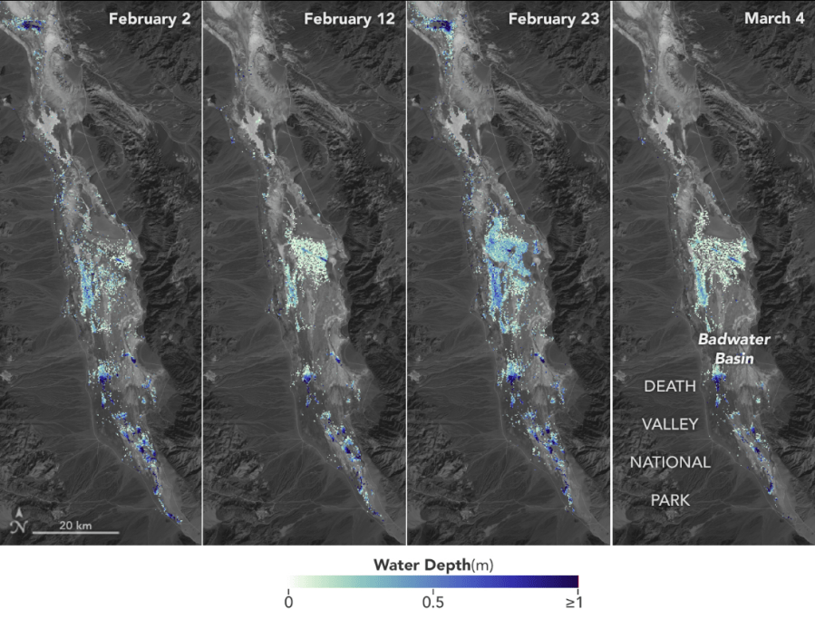
NASA’s U.S.-French Surface Water and Ocean Topography (SWOT) satellite, which launched in December 2022 from Vandenberg Space Force Base in central California, found that water depths in the temporary lake ranged from about 3 feet to less than 1.5 feet over the course of about six weeks.
California’s Death Valley reaches 128 degrees
The SWOT satellite also found that right after a series of storms in early February, the temporary lake was about 6 miles long and 3 miles wide.
To estimate the depth of the lake, NASA researchers used water level data collected by SWOT and subtracted corresponding U.S. Geological Survey land elevation information for Badwater Basin.
“This is a really cool example of how SWOT can track how unique lake systems work,” said Tamlin Pavelsky, the NASA freshwater science lead for SWOT and a hydrologist at the University of North Carolina, Chapel Hill.
Did California really have a ‘super bloom’ this spring? An expert weighs in
Visitors to Death Valley and “Lake Manly” are allowed to walk in the water but the National Park Service asks that people do not walk in muddy areas where they will leave footprints as they can last for years.
The National Park Service noted there are also wildflowers blooming in Death Valley National Park, with the best places to view them being Panamint Valley and east of Furnace Creek on CA-127 & NV-373.
The SWOT satellite was jointly developed by NASA and the French space agency, CNES (Centre National d’Études Spatiales), with contributions from the Canadian Space Agency (CSA) and the UK Space Agency.
California designates Mojave desert tortoise as endangered
NASA’s Jet Propulsion Laboratory, which is managed for the agency by Caltech in Pasadena, California, leads the U.S. component of the project. To learn more about SWOT, visit swot.jpl.nasa.gov.
For more information on Death Valley National Park, including roads and locations, road status, news and alerts, paved roads, unpaved, backcountry roads, closures, campgrounds and much more, visit nps.gov/deva/planyourvisit/conditions.htm.
For the latest news, weather, sports, and streaming video, head to FOX 5 San Diego & KUSI News.


