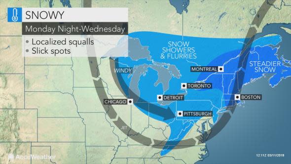
Dangerous snow squalls to hit Great Lakes, interior Northeast in wake of nor'easter
Biting winds and travel-snarling snow squalls will sweep through the Great Lakes and interior Northeast during the first half of the week.
Inland areas that will be spared from the latest nor'easter will not be sheltered from the harsh cold and snowy conditions that punch southward from Canada behind the storm.
A wave of cold air aloft will generate widespread snow showers from the Upper Peninsula of Michigan southward to the Ohio Valley and eastward to the central Appalachians and eastern Great Lakes spanning Monday night into Wednesday.
Some of the snow will extend into the mountains of eastern Tennessee and western North Carolina.
The pattern will be conducive to generating sudden snow squalls, which are notorious for triggering multi-vehicle pileups, similar to what occurred along Interstate 94 in Michigan to end this past week.
Those with travels plans along interstates 69, 70, 75, 79, 80, 81, 86, 90, 94 and 96 during the first half of this week will be at risk of encountering rapidly changing weather conditions and should be prepared to slow down and turn their headlights on when visibility is reduced.
When a snow squall is encountered, visibility can go from mostly clear to whiteout conditions in a matter of seconds.
Some of the snow will be heavy enough to overcome the strong March sun and quickly cover roadways with a slushy accumulation.
Locations that are hit with persistent snow bands could pick up a quick coating to a few inches of snow.
Erie, Pennsylvania, is expected to add to its impressive snowfall total since December 2017, which is nearing 200 inches.
Residents itching to get outside and enjoy the extended daylight hours will not be able to do so without layering on winter attire for much of the week.
Cold, harsh winds from Canada will accompany the surge of snow.
"While Tuesday will be the coldest day of the week in the Great Lakes region, residents throughout the I-95 corridor will deal with the worst of the chill on Wednesday," AccuWeather Meteorologist Kyle Elliott said.
AccuWeather RealFeel® Temperatures will be held in the teens over the interior and 20s F along the coast.
"In the I-95 corridor, temperatures will struggle to crack the 40-degree Fahrenheit mark from New York City to Baltimore on Wednesday, a mark more typical of mid-January than mid-March," he added.
A few of the snow showers that will riddle interior areas may make it to part of the Atlantic Coast at midweek.
Anyone who may lose power during the upcoming nor'easter will need to consider seeking shelter at a hotel or other dwelling where heat is available in order to stay warm and avoid cold-related illness such as hypothermia.
While the frequency of snow showers is expected to lessen past midweek, especially around the central Great Lakes, the brisk, cool conditions will take longer to scour out of the region, likely lasting through the end of the week.
