Dangerous, multiday severe weather outbreak looms for a dozen states in central US

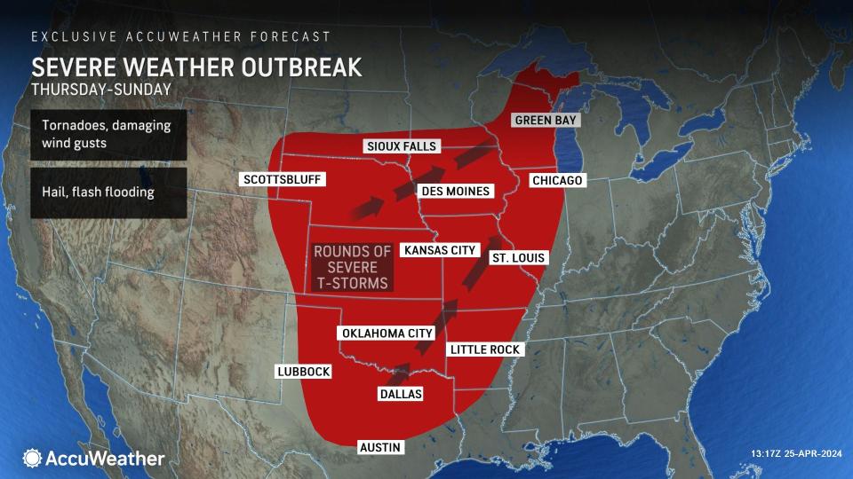


A dangerous severe weather event will threaten millions across more than a dozen states in the nation's heartland, starting during the latter part of this week and continuing through the weekend. There is a significant risk to lives and property, AccuWeather meteorologists warn.
Months ago, AccuWeather's long-range meteorologists began raising concerns about significant severe weather from late April to mid-May and stepped up the messaging for the central United States last week.
 |
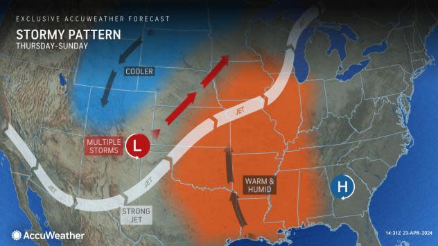
"This will be a multiple-day event in the central U.S.," AccuWeather Chief On-Air Meteorologist Bernie Rayno said. "Two storms, off the Pacific coast on Tuesday, will swing across the West and cause moisture to surge northward from the Gulf of Mexico while, at the same time, temperatures surge."
The magnitude and location of the threats will vary daily, but the setup will allow severe thunderstorms capable of producing large hail, powerful straight-line wind gusts, flash flooding and tornadoes.
In the busy pattern, severe weather may affect some locations two or three days in a row.
 |
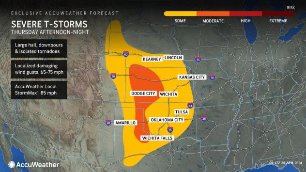
As the first storm rolls onto the Plains, thunderstorms will erupt and turn severe from northeastern and north-central Texas to southern Nebraska Thursday afternoon. The severe weather threat will continue throughout Thursday night as storms progress eastward across the central and southern Plains.
 |
As the first storm pushes eastward, the threat of torrential downpours, large hail, damaging wind gusts and isolated tornadoes will continue to ramp up over the middle of the U.S.
"The setup for Friday centered on Iowa looks very similar to April 16, when a dozen tornadoes touched down in the state," Rayno said.
 |
At this time, AccuWeather has a moderate risk of severe weather on Friday for much of Iowa, eastern Nebraska, northeastern Kansas and northern Missouri, with a high risk for southwestern Iowa and northwestern Missouri.
The severe weather threat Friday will extend along an approximate 1,000-mile swath from southern Minnesota to central Texas. The area covered by severe weather Friday is about a half million square miles and encompasses much of the lower portion of the Great Plains and nearly half of the Mississippi Valley. Cities at risk of severe weather Friday include Kansas City and Springfield, Missouri; Tulsa, Oklahoma; Topeka, Kansas; Fort Smith, Arkansas; Omaha, Nebraska; Des Moines, Iowa; and Dallas.
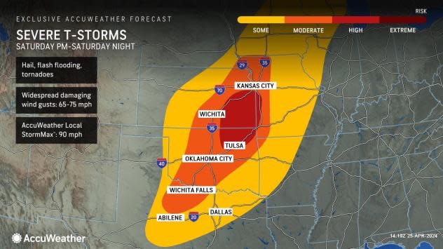
Of all the days during the severe weather outbreak, Friday and Saturday may bring the most powerful and, correspondingly, the most dangerous storms.
As the first storm system lifts northward, it will spark locally severe storms in parts of the Upper Midwest on Saturday. The risk of powerful storms packing strong wind gusts and hail will extend to the shores of Lake Superior in the Upper Peninsula of Michigan.
 |
The main threat of damaging storms will remain focused farther to the south over the Central states.
Severe weather will ramp up over northwestern and north-central Texas and northeastward to much of Oklahoma, central and eastern Kansas, northern and western Missouri, southeastern Nebraska, southwestern Iowa and western Arkansas, AccuWeather Senior Meteorologist Matt Benz said.
"This could evolve into a fast-moving or quickly evolving severe weather event for the Plains states later Saturday and Saturday night, after a quiet start to the day perhaps," Benz said.
 |
Saturday will mark the third day in a row for a severe weather threat for Oklahoma City and Tulsa, Oklahoma, as well as Wichita and Topeka, Kansas; and Kansas City, Missouri.
"Saturday could bring another day where there are a dozen or more tornadoes from Kansas City to Dallas," Rayno said.
Severe weather from the second storm system in the series will continue farther to the east Sunday.
The threat of severe weather Sunday may stretch from Chicago to San Antonio. However, it is possible that the scope of severe weather may transition to more of a straight-line wind threat over much of this zone, with a few exceptions.
 |
The risk of heavy to locally severe thunderstorms is likely to press farther to the east over the Midwest and the Tennessee Valley on Monday. Details will unfold as more data is analyzed.
Another factor with the frequency of storms is heavy rain and flash flooding.
At this time, AccuWeather meteorologists believe there is an enhanced risk of flash flooding from central Kansas to central Arkansas, which includes much of central and eastern Oklahoma, western and central Missouri and southeastern Iowa into western Illinois through Sunday night.
 |
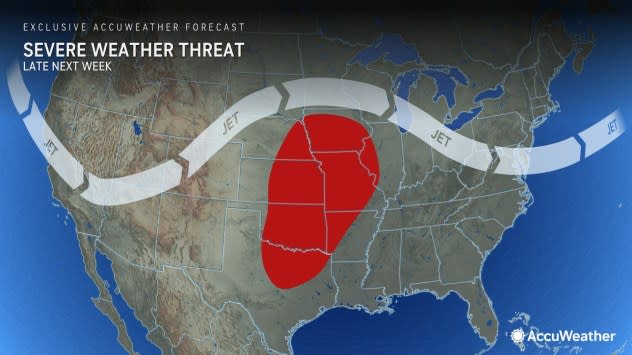
AccuWeather meteorologists are already looking ahead to the next ramp-up of severe weather in the Central states.
The same pattern is likely to repeat late next week, affecting the same areas in the path of storms from late this week to this weekend.
 |
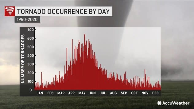
From a climatological standpoint, the stretch from mid-April to late May marks a strong upturn in the number of tornadoes in the U.S., so the anticipated pattern is not highly unusual. However, it should be respected, as dozens of tornadoes will likely be produced in the pattern over several days.
All it takes is one tornado to strike a farmstead or populated area to threaten lives and lead to great destruction.
 |
Want next-level safety, ad-free? Unlock advanced, hyperlocal severe weather alerts when you subscribe to Premium+ on the AccuWeather app. AccuWeather Alerts™ are prompted by our expert meteorologists who monitor and analyze dangerous weather risks 24/7 to keep you and your family safer.
