Crews find destructive Canada Day tornado in Alberta was an EF4

The large and destructive tornado that tore through portions of central Alberta on Saturday afternoon was rated an EF4 on the Enhanced Fujita scale, making it the highest-rated Alberta tornado since Edmonton in 1987, according to a preliminary survey by crews with Western University’s Northern Tornadoes Project (NTP) and Environment and Climate Change Canada (ECCC).
A summary compiled by ECCC reported nine homes damaged by the tornado between the towns of Didsbury and Carstairs, located west of the QE2 about halfway between Calgary and Red Deer.
The NTP’s ground crew conducted a preliminary survey of the damage and found evidence consistent with maximum winds of 275 km/h, making the tornado an EF4 on the Enhanced Fujita Scale.
An NTP investigation, in collaboration with @ECCCWeatherAB, has concluded that the worst damage from the July 1st Didsbury tornado is rated EF4 on the Enhanced Fujita scale, making it the highest-rated AB tornado since Edmonton in 1987.Full details: https://t.co/bECmqDlS3F... pic.twitter.com/HGFkwjV1Vp
An NTP investigation, in collaboration with Northern Tornadoes Project 🇨🇦 on Twitter: "An NTP investigation, in collaboration with @ECCCWeatherAB, has concluded that the worst damage from the July 1st Didsbury tornado is rated EF4 on the Enhanced Fujita scale, making it the highest-rated AB tornado since Edmonton in 1987.Full details: https://t.co/bECmqDlS3F... pic.twitter.com/HGFkwjV1Vp / Twitter", has concluded that the worst damage from the July 1st Didsbury tornado is rated EF4 on the Enhanced Fujita scale, making it the highest-rated AB tornado since Edmonton in 1987.
Full details: Northern Tornadoes Project 🇨🇦 on Twitter: "An NTP investigation, in collaboration with @ECCCWeatherAB, has concluded that the worst damage from the July 1st Didsbury tornado is rated EF4 on the Enhanced Fujita scale, making it the highest-rated AB tornado since Edmonton in 1987.Full details: https://t.co/bECmqDlS3F... pic.twitter.com/HGFkwjV1Vp / Twitter"… Northern Tornadoes Project 🇨🇦 on Twitter: "An NTP investigation, in collaboration with @ECCCWeatherAB, has concluded that the worst damage from the July 1st Didsbury tornado is rated EF4 on the Enhanced Fujita scale, making it the highest-rated AB tornado since Edmonton in 1987.Full details: https://t.co/bECmqDlS3F... pic.twitter.com/HGFkwjV1Vp / Twitter"— Northern Tornadoes Project 🇨🇦 (@westernuNTP) Northern Tornadoes Project 🇨🇦 on Twitter: "An NTP investigation, in collaboration with @ECCCWeatherAB, has concluded that the worst damage from the July 1st Didsbury tornado is rated EF4 on the Enhanced Fujita scale, making it the highest-rated AB tornado since Edmonton in 1987.Full details: https://t.co/bECmqDlS3F... pic.twitter.com/HGFkwjV1Vp / Twitter"
Experts use the EF-Scale to estimate a tornado’s wind speeds based on the extent of the damage left behind by the storm.
DON'T MISS: Violent tornadoes are sorely undercounted, study shows
The tornado grew an estimated 620 m wide and carved a path across the Alberta landscape measuring 15.3 km long, the crews said.
No injuries or deaths were reported in the wake of Saturday’s storm.
Three of the nine homes were completely destroyed, ECCC said in a summary issued Sunday, and crews noted additional damage to some agricultural and electrical infrastructure in the area.
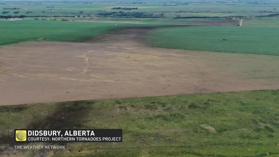
The tornado’s destructive power was evident in photos and videos from the region, which showed many trees stripped of branches and bark, as well as dirt scoured out of the ground along the tornado’s path.
Across Canada, there have been only 21 'violent' tornadoes rated at F/EF4 or higher. One of these was Canada's only tornado rated at F5 - the Elie, Man., tornado of 2007. Most of the others (12) have been in southern Ontario. Saskatchewan and Manitoba have also experienced F4-rated tornadoes (three in Saskatchewan, all 1920 and earlier; two in Manitoba from 1977 and 1994).
A highly favourable environment built over the western Prairies through the afternoon hours on Canada Day. A low-pressure system pushed into the region, providing the spark needed for towering thunderstorms to develop in a hurry. Plenty of energy near the surface fuelled these storms beyond severe limits, producing very large hail, damaging winds, and rotation.
Saturday’s tornadic thunderstorm was one of many intense severe thunderstorms to roll across the Prairies over the long holiday weekend. Many of these storms were particularly intense, producing hail the size of golf balls or larger.
WATCH: Tornado leaves path of destruction in central Alberta
The Northern Tornadoes Project is an ongoing effort by meteorologists with Western University to better understand and predict tornadoes that touch down across Canada.
RELATED: Experts find that Canada tied its all-time tornado record in 2022
The country averages about 60 tornadoes per year, but the true number is likely much higher given that many severe thunderstorms occur across unpopulated areas where radar coverage and ground reports are sparse or nonexistent. Canada is the world’s second-largest country by total land area, and it ranks second in annual tornado activity only behind the United States.
Crews with the NTP conduct ground surveys, aerial pass-overs, and even utilize satellite imagery to spot and analyze damage paths left behind by potential tornadoes.
A true accounting of the number and strength of tornadoes across Canada will help meteorologists better predict and warn these hazards in the future, keeping folks safe when dangerous weather looms on the horizon.
Thumbnail image courtesy of David Hart.

