'Very dangerous' avalanche warning persists for parts of B.C.
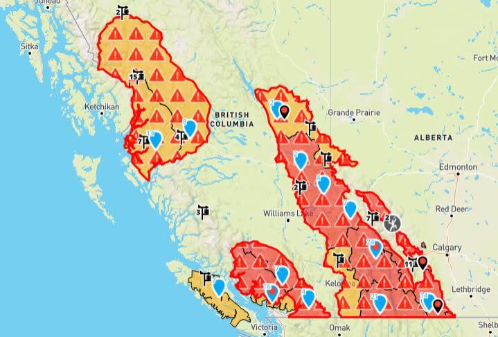
Avalanche Canada has issued an avalanche warning for wide swaths of the British Columbia Interior into parts of Alberta, with a ranking of "dangerous" or "very dangerous" conditions applied to mountains across the province.
The warning, which can be viewed on the avalanche.ca website, applies to mountainous regions of Vancouver Island, southwestern and northwestern B.C., as well as the eastern part of the province including the Rockies into Alberta's Kananaskis Country.
Avalanche Canada says recent storms have deposited a large amount of snow on "weak layers" established early this month that are prone to human-triggered avalanches.
"This has been the biggest storm of the season, and we know backcountry users are eager to enjoy the snow," said Avalanche Canada forecaster Tyson Rettie.
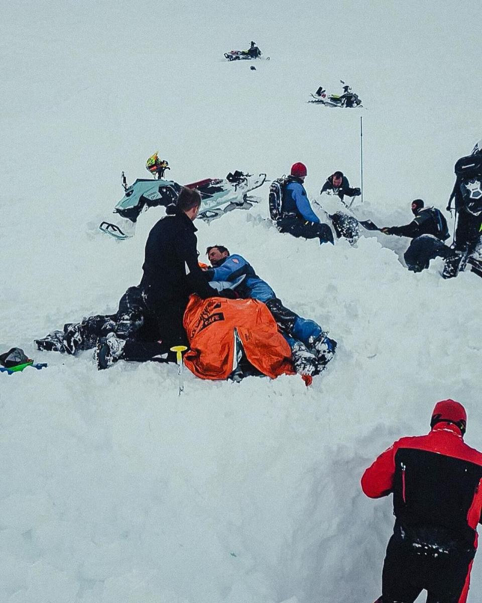
A photo posted by Great Canadian Tours shows rescue operations of a snowmobiler who was trapped in mountain snow near Revelstoke, B.C. on Feb. 26, 2024. (Great Canadian Tours)
"But it's vital to not underestimate the instability of these weak layers. Any avalanche triggered on them could be deadly."
The agency recommends users stick to lower-angle slopes and smaller climbs to "minimize the consequences of an avalanche."
On Monday, one person was rescued from an avalanche in the mountains near Revelstoke, in the B.C. Kootenay region, while Sunday saw the death of a snowmobiler caught in avalanche in southern Alberta.
This special warning is in effect from Thursday to the end of next Monday, March 4.
Highways reopened, dangerous driving
High-elevation stretches of two highways in the B.C. Interior have meanwhile reopened after they were shut down by heavy snowfall and winter storm conditions this week.
The Coquihalla Highway was closed in both directions from Hope to Merritt, B.C., for 10 hours following an early-morning vehicle crash Thursday, according to DriveBC. It has since reopened.
Highway 1 from Revelstoke to Golden was also closed overnight Wednesday and into Thursday due to avalanche risk, with no detour available The roadway reopened just before 1 p.m. PT Thursday.
The highway remains under a winter storm warning, with another five centimetres of snow expected over Thursday, Environment Canada says.
Traffic cameras at the summit of the Coquihalla show a significant accumulation of snow on the roadway.
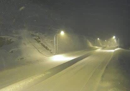
Highway camera images of the Coquihalla Highway summit early Thursday. (Government of B.C.)
Contractors and tow truck drivers responsible for maintaining and providing service along the Coquihalla said the snow storm Wednesday into Thursday made for treacherous driving conditions along the popular route.
"Just really wet, icy snow," said Dave Duncan, general manager at Yellowhead Road and Bridge Ltd. "Even cars and trucks with good tires are struggling to stay straight."
Other passes
Environment Canada also has winter storm warnings in place Thursday for the Eagle Pass to Rogers Pass section of the Trans Canada Highway, for Highway 3 from the Paulson Summit to the Kootenay Pass and Highway 16 from Tête Jaune Cache to the Alberta border.
Up to 15 centimetres of snow is forecast to accumulate in those areas. Snowfall and gusty winds are expected to begin to ease on through the day, said the forecaster.
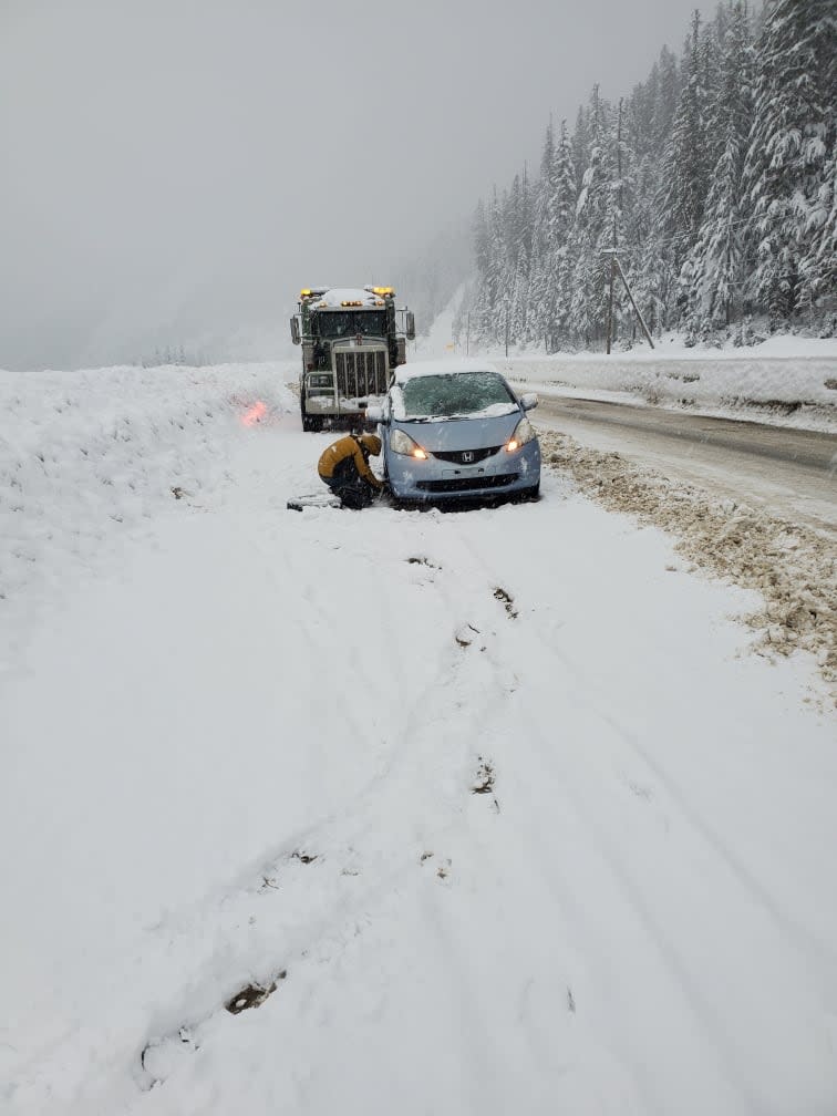
A driver changes a tire during a snow storm on the Coquihalla Highway on Wednesday. (Al Quiring)
The weather agency says the Pacific frontal system behind the winter storm has dropped 57 centimetres of snow in Whistler, up to 60 centimetres at the Sea to Sky Highway and 32 centimetres at Coquihalla summit.

