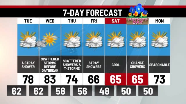
A few frost chances this week, some days of sun and warmth too
TONIGHT: Clearing Clouds, Chilly. Chance of Frost. Lo 36. Winds W 5 mph.
MONDAY: Mostly Sunny, Seasonable. Hi 61.
TUESDAY: Mostly Sunny, Warm. Hi 67.
Today brought a noticeable change with temperatures falling to the 50s rather than near 70° as it was yesterday. A lot more clouds were also around, however the weekend stayed dry on the whole. Tonight will be chilly, similar to last night. A chance of frost exists due to lows in the mid-30s, however if the wind continues to blow even lightly that should prevent a widespread frost. Either way you should play it safe and protect any sensitive plants. By Monday afternoon temperatures rebound to the low 60s with plenty of sunshine.
We’ll see things rebound into the mid 60s by Tuesday before a cold front Wednesday brings a brief cooldown. Wednesday’s showers appear very light, however the clouds and light rain combined will keep the air damp. The inconsistency in temperature continues as the mercury rises into the mid 60s by next Saturday, with mid-70s likely by next Sunday if rain holds off. Next weekend’s warmth is brought eastward by a ridge of high pressure to our south. This type of weather usually brings showers initially with the warm front but a potential big temperature surge which appears likely by next Sunday-Monday.
-Meteorologist Dan Tomaso
For the latest news, weather, sports, and streaming video, head to ABC27.

