Coastal storm to bring substantial snow to Hudson Valley this weekend
A coastal storm could bring up to a foot of snow to parts of the region on Saturday.
AccuWeather senior meteorologist Paul Walker said the first flakes will begin falling in the Hudson Valley region late Friday night, possibly not until after midnight, and continue through the day Saturday and into the evening.
"This thing is still almost 72 hours away," Walker said Wednesday. "So there's still a degree of uncertainty about the forecast. But we could see a period of decent snowfall on Saturday."
The National Weather Service has not yet issued any storm watches, warnings or advisories for the region.
But as things stand now, the seven-county Hudson Valley area – including Westchester, Putnam, Dutchess, Rockland, Orange, Ulster and Sullivan counties – could see anywhere from a few inches to a foot of snow.
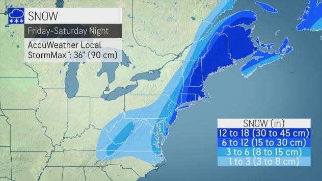
Walker said the farther east you go in the region, the more likely you are to see anywhere from 6 to 12 inches of snow. The farther west you go, the more likely snow totals will be closer to 3 to 6 inches.
"It's also going to be windy, so there will be a lot of blowing and drifting snow," he said. "You should get your milk and bread and whatever else you need ahead of time, because you will want to stay off of the roads on Saturday."
Plunging temps mean outdoor fun: Where to skate, check out an ice castle
Potholes: Hochul declares $1B war on potholes as she tries to connect with commuters
Storm prep: 5 essential ways to prepare for a snowstorm
It's also going to be very cold. Walker said temperatures Saturday will only be in the teens all day long, and on Saturday night the low will be around 10 degrees. With the wind chill effect factored in, it will feel even colder.
The storm's effects will be worse the farther east you go. While New York City also can expect about 6 to 12 inches of snow, on Long Island there could be as much as 12 to 18 inches, Walker said.
And AccuWeather is predicting the storm will produce bomb cyclone effects in the Boston area.
Locally, temperatures are expected to rise in the days after the storm passes. By Tuesday, forecasts are calling for highs in the 30s across the region, creating a risk for melting and flooding conditions.
This article originally appeared on Rockland/Westchester Journal News: Weekend storm to bring up to foot of snow to New York's Hudson Valley
