Cities on both coasts struggled to remain above water this winter as sea levels rise
Within the span of about six weeks this winter, a trio of fishing shacks were swept away in Maine, a piece of the backyard vanished from an oceanfront home Kid Rock owns in Florida and high tides in California sent beachgoers running for their lives.
With every inch of sea level rise, communities along coasts and rivers near the sea face greater risks and events like the king tides and severe storms this winter further illustrated the growing threat.
“The start of this year has been absolutely incredible," said John Dickson, president and CEO of Aon Edge, a private flood insurance provider. “The weather is changing rapidly and the consequences are dramatic.”
High-tide flooding in the U.S. occurs nearly three times as often today as it did in 2000, according to William Sweet, an oceanographer with the National Oceanographic and Atmospheric Administration's National Ocean Service. For the meteorological year that ends in April, NOAA had forecast a 9-14 day increase in high-tide flood days along the Atlantic Coast compared to 2000, thanks to a combination of the El Niño pattern in the Pacific Ocean and sea level rise.
Over just six days in January, between the 8th and 13th — during the new moon high tides, known as king tides, and winter storms — the National Weather Service reported coastal flooding in 57 counties across 17 states on the Atlantic Seaboard and Gulf of Mexico.
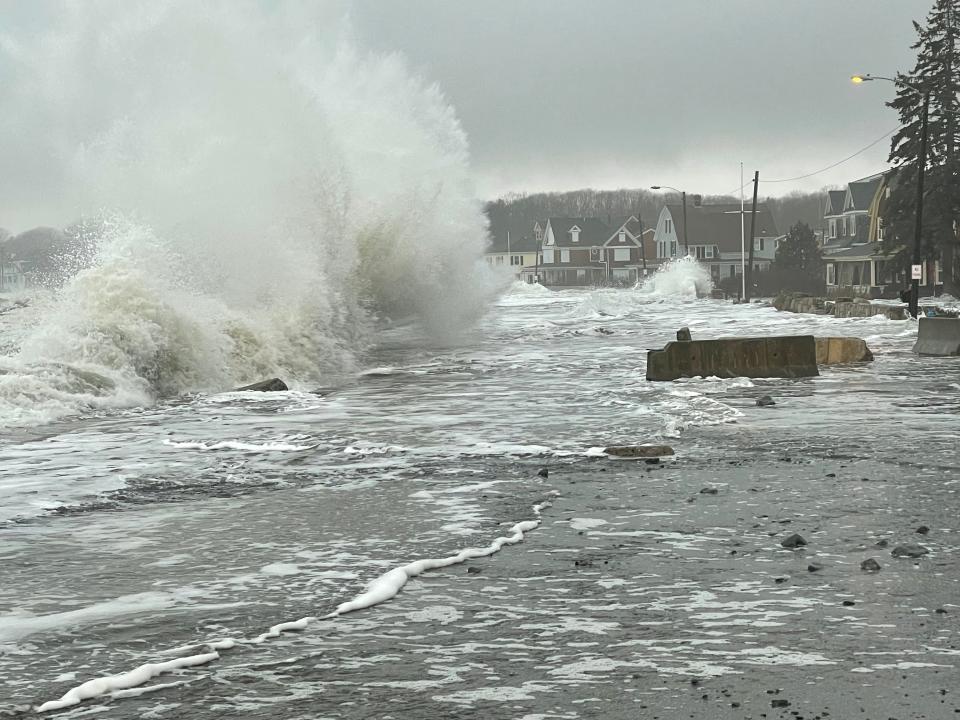
High tide records were set in Bar Harbor and Portland, Maine.
Erosion on one section of coastal Rhode Island was the worst since Superstorm Sandy.
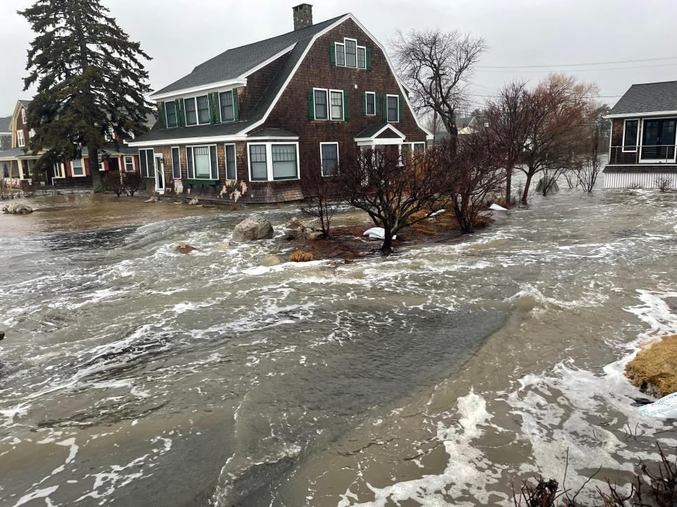
A high tide rushed up Maine’s Kennebunk River, flooding properties on either side.
Rising sea levels, warmer water temperatures and more intense rainfall compound the effects of natural weather events such as high tides and the El Niño, leaving communities struggling for answers. As erosion and tidal inundation accelerate and reach further inland, the flooding events highlight the need for better decisions, better mapping and a focus on improving disaster preparedness and catastrophe models, Dickson said.
Local, state and federal governments are trying a variety of approaches to work together to address the massive challenges ahead, including devoting millions to protect and restore coastal wetlands that could help buffer future impacts.
Federal officials collaborated with partners on the recent release of two major coastal mapping projects. The National Oceanic and Atmospheric Administration published high resolution mapping to help communities map emerging threats and the U.S. Geological Survey partnered with Virginia Tech on a project looking at the rates of land subsidence.
Over 30 years, the 20-year average number of high tide flood days for the meteorological year between May and April has increased at all but three locations on the U.S. mainland with reliable measurements dating back to the 1970s, according to NOAA data. The three are on the California coast, Port San Luis, San Francisco and Alameda.
That number is six times higher in Charleston, South Carolina and twice as high in Portland, Maine.
While sea levels aren't rising as fast on the Pacific Coast, Sweet said higher ocean levels during El Niño exacerbate things and can bring "a decade's worth of sea level rise in a season."
Maine town used to flooding — 'but not like this'
In Kennebunkport, more than a foot of water flowed into the downtown village during one flood event this winter, a trend occurring more frequently with routine astronomical high tides, Town Manager Laurie Smith told USA TODAY.
The town was founded in 1653, more than a century before the Industrial Revolution, when the world began pumping more of the greenhouse gasses into the air that started warming the planet. Today, more than 300 years later, leaders in the region are discussing potential solutions to the problems created by a warmer world.
They’ve seen flooding before, “but not like this,” said Laura Dolce, executive director of the Kennebunk-Kennebunkport Chamber of Commerce. This time rushing water found its way into some new areas that were “quite surprising.”
The ocean has always been the community’s economic “bread and butter,” and people have visited for that reason for hundreds of years, Dolce said. Now that same sea “threatens the very livelihoods of those businesses.”
Big waves off California signal an uncertain future
In Ventura, California, storm-driven waves fueled in part by warmer waters offshore flooded streets and sent bystanders running for safety in late December.
Extreme storms and large swells associated with El Niño this winter show what future sea level rise will look like, said Paul Jenkin, the Ventura campaign coordinator for the Surfrider Foundation, an organization dedicated to protecting and preserving the ocean’s waves and beaches.
“That’s my concern, as somebody who’s watched this for decades, to start seeing these kinds of impacts, knowing what is to come,” Jenkin said.
Although there has been discussion in Ventura about a managed retreat from the shoreline — to move infrastructure away and restore the natural shoreline — private property owners along the coast don’t want to retreat, Jenkin said. “That has become a bad word. At the end of the day, it’s going to be the only economically feasible way to manage sea level rise.”
“To think these are one time events that aren’t going to recur is just foolhardy,” he said. “Our concern is that we’re going to lose our recreational beaches. It will just be seawalls and other coastal structures with no sandy beach left.”
Flood days keep inundating South Carolina's 'low country'
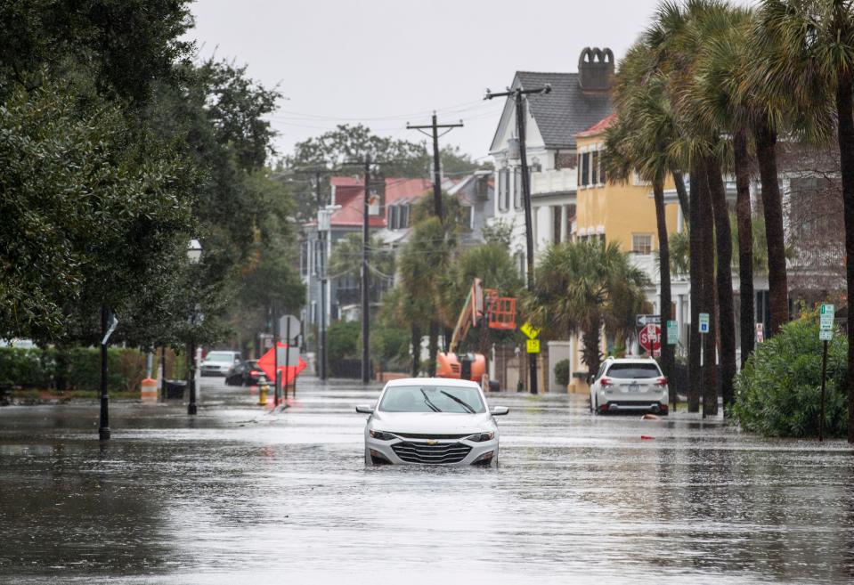
Charleston, South Carolina and the surrounding region is known as “the low country” for a reason. Much of the area sits near sea level, and it's dominated by three rivers and boundless coastal marshes. Occasional flooding has been a problem since it was founded in 1670, but today coastal flooding occurs more often.
Cruise passengers returned to port on December 15 shocked to find their cars flooded. During a historic high tide on December 17, the city’s fire department rescued or assisted more than 40 people in flood waters. Coastal flooding was reported at least 10 times since Jan. 1.
Between 1950 and 2014, flood events in the city grew from a couple of days a year to 25 days a year. By 2050, NOAA projects the city could see 60 flood days or more each year.
Tide gauges show the city has experienced 13” of sea level rise over a century, about half that in the last 20 years, according to NOAA. The city is projected to see another 14-18 inches of sea level rise by 2050.
Dozens of projects are ongoing or underway aiming to protect the city and its historic homes and businesses.
“The water is rising, the clock is ticking, and the future of our city is in the balance,” stated former Mayor John Tecklenburg, in the latest version of the city’s flooding and sea level rise strategy.
Charleston also is one of the cities highlighted in the USGS study looking at how fast some coastal areas are sinking, even as the ocean is rising.
The study, focused on the East Coast, found the land is susceptible to sinking at a rate ranging from 1 to 2 millimeters a year, affecting up to 14 million people and more than half the crucial infrastructure in major cities along the coast.
Mapping the risk of coastal flooding
To help cities like Kennebunkport, Charleston and Ventura, NOAA recently released new high-resolution land cover data for coastal communities, to improve long-range planning and climate resilience projects, funded in part by the Bipartisan Infrastructure Law.
The maps cover 1.5 million square miles of coast, and each pixel of imagery represents a square meter, NOAA said, revealing data 900 times more detailed than previous mapping.
“We need to be able to classify how communities are changing,” said Brandon Palin, senior director for public sector science at Ecopia Tech, a mapping company that partnered with NOAA, using AI-powered technology to develop the new maps.
The maps can help communities more accurately assess flood risk and water movement across the landscape, Palin and colleague Harneet Singh, Ecopia’s director of growth and corporate marketing, told USA TODAY.
Communities can’t rely on 30-year-old data, especially when it comes to choosing where to build new infrastructure, said Palin and Singh. As one example, they pointed to how the impacts of tidal surge can change in a community where natural landscapes that once absorbed the water’s impact are now covered by buildings and pavement.
Computer models that predict future change in a community are great, but if the data you’re putting into the model is old or not necessarily accurate, then the model itself can be useless to a certain point, Palin said. The higher resolution maps can help each coastal community see its individual challenges.
'Something has to change'
Along the Kennebunk River in Maine, community officials are looking at improved mapping and have discussed options such as tide gates, a dike to hold back water or raising buildings and infrastructure, said Smith, the Kennebunkport town manager.
The potential costs for such measures seem overwhelming, but “something has to change,” said the chamber’s Dolce. “There are so many discussions right now in the state and community about what coastal resiliency will look like and what kind of initiatives we can take.”
“We either have to make those changes, and it’s going to be really expensive, or you’re going to have to let the sea take everything,” she said. “And I don’t think – since this is the economic driver for the town – that that’s a possibility. I think we have to come up with a solution.”
This article originally appeared on USA TODAY: Winter flooding shows climate change effects on both US coasts

