Check out the big road projects planned for Monmouth and Ocean counties through the 2020s
From bridges with "100% section loss" in "severely rusted reinforcing steel" to easing traffic jams, here is a look at upcoming road projects with expected federal funding in Monmouth and Ocean counties.
The projects range from the multiyear $184.4 million Oceanic Bridge replacement project between Rumson and Middletown to the $5.575 million Route 35 guide rail replacement in Ocean Township, Eatontown and Shrewsbury.
The projects fall into four general stages — concept development, preliminary engineering, design and right of way and construction.
Concept development is the first stage that assesses the issue at hand. It is followed by preliminary engineering. According to Ted Ritter, external affairs manager at the North Jersey Transportation Planning Authority, during preliminary engineering, details are refined for environmental approvals.
Jersey Shore roads: It's getting safer to drive around Brick, but here's why drivers still feel stressed
The design phase takes all the recommendations and develops the final design before construction begins. Right of way is where the state, county or local government acquires land needed to implement certain projects. Construction is when the work starts.
According to Melissa Hayes, spokeswoman for the NJTPA, project schedules change and "frequently (get) updated."
The North Jersey Transportation Planning Authority is a state planning organization that oversees funding for 13 counties in New Jersey that include Monmouth and Ocean counties. Project descriptions here were pulled from NJTPA Transportation Improvement Program Project Status Reports, NJDOT Public Information Center reports, planned advertisement and procurement lists, as well as websites created specifically for the projects in question. Projects over $30 million are listed below.
Construction phase
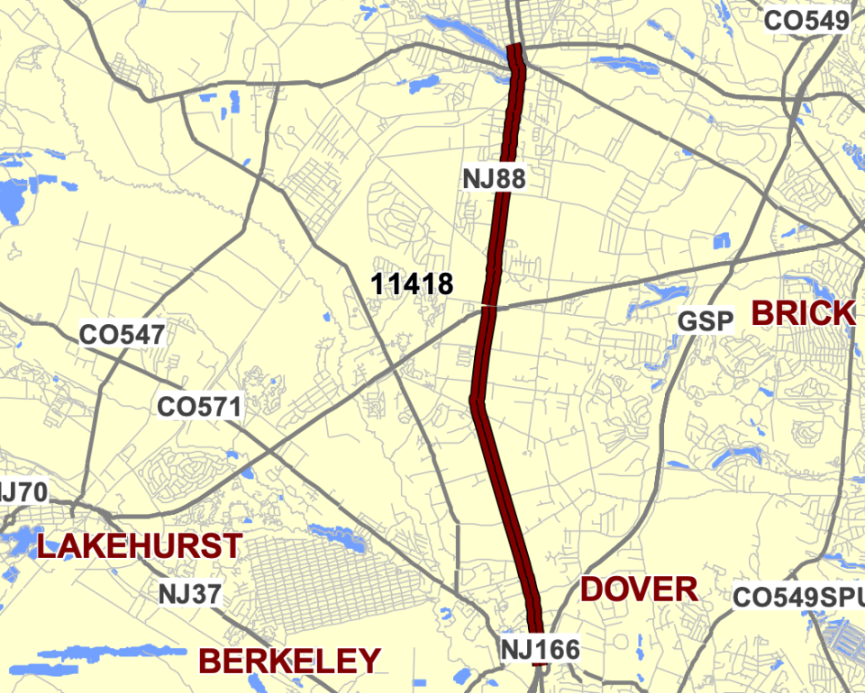
Route 9 in Toms River and Lakewood
Location: From Indian Head Road to Central Avenue/Hurley Avenue
Purpose: To resurface the pavement, add additional turn lanes on Route 9 and upgrade guide rails. The project would also implement ADA compliance and widen the shoulder of Route 9 to improve bicycle safety. Two new traffic signals would be added to the intersection of Route 9 and Oak Street and Route 9 and Chateau Drive/Broadway. The contract was awarded in 2022 and construction is expected to be completed in 2025.
Cost: Estimated to be $77.135 million, the project is anticipated to be funded by the federal National Highway Performance Program.
Jersey Shore roads: Lakewood car crashes have jumped 69% in 20 years. So what are they going to do about it?
Route 66 in Neptune
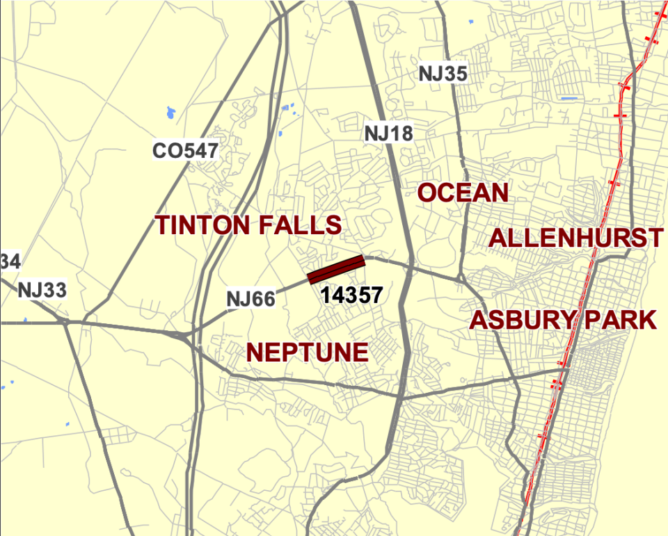
Location: Route 66 from Jumping Brook Road to Bowne Road/Wayside Road
Purpose: To add an additional lane in each direction and separate the road by a grass median. A two-lane roundabout is proposed to replace the intersection of Route 66, Asbury Avenue, Bowne Road and Wayside Road. The project is proposed to be advertised for construction in April. Construction could begin this year and end in 2026.
Cost: Estimated to be $63.155 million, the project is anticipated to be funded by the federal Surface Transportation Block Grant Program.
ADA improvements in multiple towns
Purpose: To bring the following roads into Americans with Disabilities Act compliance:
Route 71 from Sea Girt Avenue in Sea Girt to Route 35 in Belmar.
Route 9 from Alexander Avenue in Howell to Route 79 in Freehold.
Route 36 from Miller Avenue in Highlands to Union Avenue in Union Beach.
Route 35 from Cherry Tree Lane in Middletown to Route 9 in Sayreville.
Sections of Route 34 and Route 35 in Colts Neck and Wall .
Route 9 near Pohatcong Lake Dam and Tuckerton.
According to DOT spokesperson Leanna Nelson, the ADA improvements include "improvements to traffic signals, signage, striping, pavement markings, pedestrian push-buttons, crash cushions and highway lighting. Pedestrian curb ramps will be replaced or upgraded to meet current ADA compliance standards. Additional work includes milling and paving, and improvements to the drainage systems."
Nelson wrote in an email that the project's contract is expected to be awarded in 2025 and take five years to complete.
Cost: Estimated to be $59.88 million, split into two contracts that include roads in other counties. The project is anticipated to be funded by the federal National Highway Performance Program.
'Sleeping giant': NJ Transit eyes affordable housing, sidewalks for Route 9 bus commuters
Route 166 in Toms River and South Toms River
Location: Route 166 bridges over Toms River
Purpose: To replace the structurally deficient bridges built in 1928. The project will also address sidewalks, ADA improvements and "sour critical issues," which would remove accumulated streamed materials that could cause problems the bridge's structure. The project has not been advertised, but it is estimated to be completed by spring 2027.
Cost: Estimated to be $32.6 million, the project is anticipated to be funded by the federal Bridge Formula Program.
Other projects pending federal approval for construction include a $21.83 million pavement rehabilitation project covering Route 79 from Route 9 in Freehold Township to Route 34 in Matawan that is estimated to be completed in fall 2026; and a $13.318 million bridge replacement project to replace the Route 88 bridge linking Brick and Point Pleasant that is estimated to be completed in spring 2027.
Warehouse traffic: Developer wants four industrial buildings across the street from Monmouth Battlefield
Design
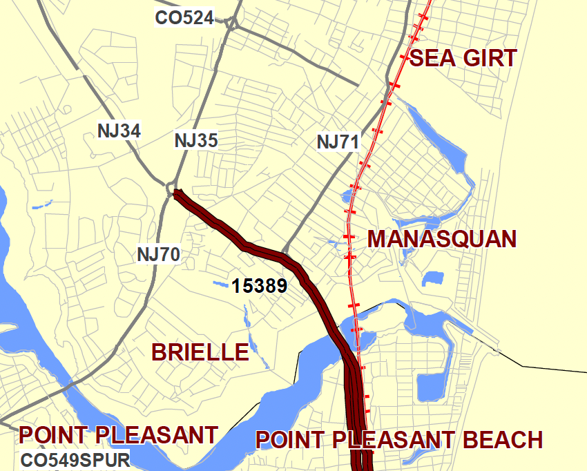
Route 35 in Point Pleasant Beach
Location: Route 35 from Osborne Avenue to the Manasquan River; Route 35 from Old Bridge Road to Route 34 and Route 70
Purpose: To reconstruct the pavement, address drainage issues and implement ADA improvements. The project is estimated to be completed in the fall of 2027.
Cost: Estimated to be $33.4 million, the project is anticipated to be funded by the federal National Highway Performance Program.
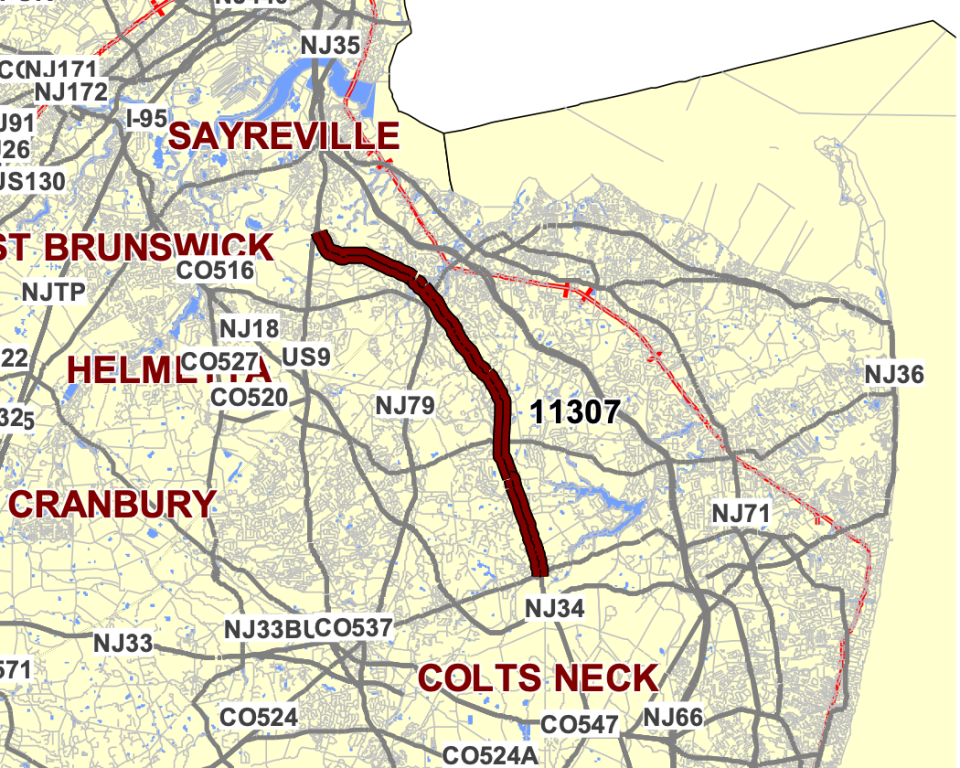
Route 34 in Colts Neck to Old Bridge
Location: Route 34 from Route 537 to Washington Avenue
Purpose: To reconstruct the pavement, fix guide rails and address drainage issues. The project will include "earthwork to re-establish eroding slopes behind the guiderails, upgrading the guiderails, repairing damaged drainage and outfall structures." It will also replace the bridge deck and superstructure of the bridge over Gravelly Brook on Route 34. The project is estimated to be completed in the summer of 2029.
Cost: Estimated to be $147.54 million, the project is anticipated to be funded by the federal National Highway Performance Program.
Red Bank Broadwalk coming back for good: Here's what will be new with outdoor dining
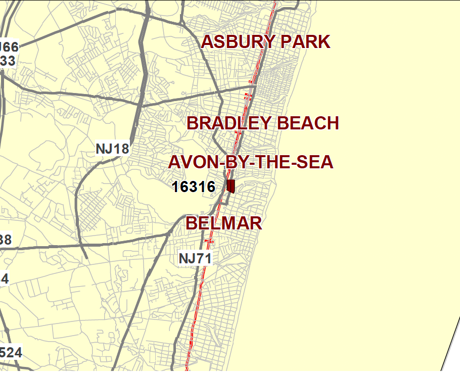
Route 71 in Belmar and Avon
Location: Route 71 bridge over Shark River
Purpose: To replace the movable bridge built in 1932 and modified in 1991. The bridge had undergone repairs in September 2021 after being stuck in a partially-opened position. The project is estimated to be completed in early 2029.
Cost: Estimated to be $163.2 million, the project is anticipated to be funded by the federal Bridge Formula Program and the National Highway Performance Program.
Route 71 bridge over NJ Transit railroad in Deal
Location: Route 71 bridge over NJ Transit (New Jersey Coast Line)
Purpose: To replace the structurally deficient bridge, built in 1917 and reconstructed in 1937. The proposed bridge would change the number of lanes from two in each direction to one in each direction and a center left turn lane. It would also add shoulders and sidewalks. The length of the bridge would widen in anticipation of potential future NJ Transit lines. The project would also close the intersection of Elberon Boulevard and Route 71 into a cul-de-sac. The project is estimated to be completed in the fall of 2030.
Cost: Estimated to be $33 million, the project is anticipated to be funded by the federal Bridge Formula Program.
Other projects pending federal funding include:
$27.5 million pavement reconstruction and traffic signal and guide rail upgrade project for Route 138 from the Garden State Parkway to Route 35 in Wall that is estimated to be completed in fall 2028.
$21.8 million bridge replacement project for Union Hill Road bridge over Route 9 in Marlboro that is estimated to be completed in fall 2028.
$18.3 million project to construct a new exit ramp south of the Exit 83 toll plaza on the Garden State Parkway in Toms River.
$16 million bridge replacement project of the Route 33 Business Bridge over Conrail Freehold Secondary Branch in Freehold Township.
$12.5 million bridge replacement project for School House Road bridge over Route 35 in Brielle that is estimated to be completed in spring 2029.
$12.4 million bridge restoration project for Chadwick Beach Island Bridge over Barnegat Bay in Toms River.
$10 million bridge replacement project for Route 35 bridge over the north branch of Wreck Pond in Wall that is estimated to be completed in summer 2026.
$8.2 million bridge replacement of the Route 36 bridge over Troutman's Creek in Long Branch that is estimated to be completed in spring 2027.
$6.8 million bridge rehabilitation project for Route 35 Northbound Bridge over Route 36 Northbound and the Garden State Parkway Ramp G.
Warehouse traffic: Neighbors fear proposed Upper Freehold warehouse could ruin life in neighboring Allentown
Preliminary engineering
Oceanic Bridge connecting Rumson and Middletown
Location: Bingham Avenue Bridge (Monmouth County Bridge S-31, also known as Oceanic Bridge) over Navesink River
Purpose: To replace the "structurally deficient and functionally obsolete bridge," which was built in 1939. The bridge's superstructure condition was considered serious as a result of "heavy rust throughout steel members with small corrosion holes in girder webs, section loss to floor beam bottom flanges, and areas of severe section loss to rivet heads at connections and bottom flanges." The substructure, which consists of everything below the bridge but above its foundation, was considered poor as a result of "wide cracking and deep spalls with exposed and severely rusted reinforcing steel (100% section loss to many bars) in the concrete columns, towers, and pier caps." An estimated project completion date has not been posted by the NJTPA.
Cost: Estimated to be $184.4 million, the project is anticipated to be funded by the federal Surface Transportation Block Grant Program (STBGP-NY/NWK).
Sharing the roads: Shrewsbury Avenue pedestrian safety improvements in Red Bank could begin early 2025
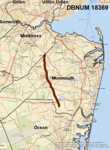
Route 9 from Howell to Old Bridge
Location: Route 9 from Salem Hill Road in Howell to Texas Road (County Route 690) in Old Bridge intersections
Purpose: To add Transit Signal Priority technology to 10 major intersections. According to Nelson with the state DOT, the project would ease congestion that is impacting bus travel times. Route 9 is a well traveled New Jersey Transit corridor. The project would build a bus lane and the TSP technology would give buses the green light as it approaches. An estimated project completion date has not been posted by the NJTPA.
Cost: Estimated to be $39.5 million, the project is anticipated to be funded by the federal Congestion Mitigation and Air Quality Improvement program.
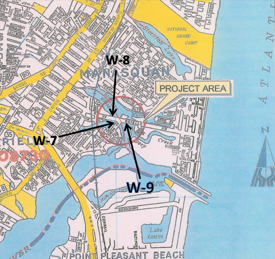
Three bridges in Brielle and Manasquan
Location: Monmouth County Bridges W7 on Green Avenue over Debbie's Creek, W8 or the Fisk Avenue culvert and W9 on Brielle Road over Glimmer Glass.
Purpose: To rehabilitate or replace three "deficient bridges." W7 was built in 1944, and in 2013, it received a sufficiency rating of 18.7 out of 100. An examination found "severely decayed pile bracing and reduced pile cross sections at (the) waterline." There were "splits and sagging in (the) timber stringers and (the) pile bent cap." W8 was built in 1946. "Extensive cracking in pipe walls with rusting and exposed reinforcement" was found. A crack on the road above the culvert indicates "deformation." W9 was built in 1889, reconstructed in 1950 and went under emergency repairs in 2014. In 2013, it received a sufficiency rating of 2, which was upgraded to 10.1 in 2015 after the repairs. The bridge has substandard live load capacity, railings, vertical clearance and mechanical and electrical systems. An estimated project completion date has not been posted by the NJTPA.
Cost: Estimated to be $35.3 million, the project is anticipated to be funded by the federal Surface Transportation Block Grant Program (STBGP-NY/NWK).
Corlies Avenue Bridge connecting Allenhurst and Ocean Township
Location: Corlies Avenue Bridge over Deal Lake
Purpose: To improve the 302-foot long Corlies Avenue Bridge, which currently has a sufficiency rating of 42.7 out of 100. The bridge was built of timber in 1941 and reconstructed with concrete in 1976. While the superstructure was rated satisfactory, the substructure received a fair rating due to "weathering to the timber piles and pile cap at all pile bents and severe heart rot." The deck of the bridge received a poor rating with potholes, cracks and "large, deep spalls with exposed and corroded rebar in the underside of deck." The proposed improvements would take in consideration pedestrians and cyclists. An estimated project completion date has not been posted by the NJTPA.
Cost: Estimated to be $32 million, the project is anticipated to be funded with the federal Surface Transportation Block Grant Program (STBGP-NY/NWK).
Other projects pending federal funding include:
$11.4 million bridge replace project for Route 34 bridge over Big Brook in Colts Neck that is estimated to be completed at the end of 2028.
$10.5 million bridge replacement project for Old Bridge-Matawan Road bridge over Lake Lefferts that connects Old Bridge with Matawan and Aberdeen.
$9.35 million streetscape project for Route 35 from County Route 18 (Belmar Boulevard/16th Avenue) to Route 71 (8th Avenue) in Belmar that could include a median island, flashing beacons and other pedestrian safety measures.
$9.25 million road reconstruction project for the Route 37 onramp to Route 35 in Seaside Park. The project would replace the S-curve with a smooth single curve.
$5.58 million guide rail replacement project for Route 35 from Route 66 to White Street/Obre Place in Shrewsbury.
Projects under concept development include:
A bridge replacement or rehabilitation project for Route 35 bridge over Edgar Felix Bicycle Path in Wall.
A bridge replacement or rehabilitation project for Route 33 bridge over Manalapan Brook in Manalapan.
A replacement of the roundabout at the Route 34 and County Route 524 (Allaire Road) intersection in Wall.
A streetscape project for pedestrian and cyclist safety along Route 9 from County Route 528/County Route 547 (Central Avenue/Hurley Avenue) in Lakewood to Estelle Lane in Howell.
A project addressing congestion at the Route 33 and Route 34 intersection in Howell.
A crash reduction project for County Route 3 from Devon Drive to Kensington Drive in Manalapan.
A congestion mitigation and pedestrian and cyclist safety project along Kennedy Boulevard and County Line Road in Lakewood.
Olivia Liu is a reporter covering transportation, Red Bank and western Monmouth County. She can be reached at oliu@gannett.com.
This article originally appeared on Asbury Park Press: Monmouth and Ocean County road, bridge projects planned for the 2020s

