Central US to face another round of severe weather into Tuesday evening
The severe thunderstorms that hammered the High Plains over the holiday weekend will shift eastward across the central United States into Tuesday night.
One of the stronger thunderstorms on Tuesday afternoon produced a tornado near Ensign, Kansas, located southeast of Dodge City.

A tornado near Ensign, Kansas, on Tuesday May 29, 2018. (Photo/Garrison Hendricks)
Over one dozen tornadoes were spawned over Wyoming, Colorado and Kansas, from Sunday through Monday, with high winds and large hail reported with storms from South Dakota to the Texas Panhandle.
NEW: more land spout #tornado action north of Flagler, CO earlier today. 3 on the ground at the same time. Tennis ball hail just north of them. @breakingweather @accuweather #cowx pic.twitter.com/f8u1RGuj5q
— Reed Timmer (@ReedTimmerAccu) May 29, 2018
Heavy storms late on Memorial Day unleashed over 7 inches of rain across western Kansas, which prompted flash flood warnings and triggered street flooding.
The slow-moving system that triggered the multiple days of violent weather will sweep into the northern and central Plains.
"Tuesday evening may be one of the most extensive evenings for severe weather so far this season," according to AccuWeather Senior Meteorologist Alex Sosnowski..
This will result in a slight eastward shift in the area at risk for severe weather, which will span from Minnesota to Oklahoma through Tuesday evening.
The storms will feed off continued record-challenging heat and high humidity.
All modes of severe weather will be possible in thunderstorm activity, including large hail and a couple of tornadoes, according to AccuWeather Lead Long-Range Meteorologist Paul Pastelok.
Damaging winds and flash flooding will also be possible.
As evidenced on Monday, flash flooding can occur despite an ongoing drought over the central Plains.
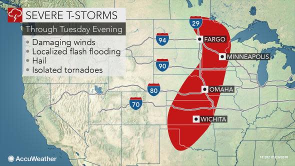
Residents from Fargo, North Dakota, to Sioux Falls, South Dakota; St. Cloud and Minneapolis, Minnesota; Sioux City, Iowa; Lincoln and Omaha, Nebraska; Salina, Wichita and Dodge City, Kansas; and Oklahoma City, should monitor the weather throughout the day and be prepared to seek sturdier shelter if necessary.
People may want to consider moving their vehicle under a carport or in a garage to prevent costly hail damage. Cellphones should be kept fully charged in case the power goes out.
The storms will cross stretches of interstates 29, 35, 70, 80, 90 and 94, causing times of poor visibility and slow travel.
Secondary roads may be closed due to flooding.
While storms over the central U.S. will tend to be more heavy and gusty as opposed to severe at midweek, Pastelok anticipates that more organized severe weather will return late in the week.
"Severe weather will start Thursday in the northern Rockies and northern Plains and move eastward into the Upper Midwest by Saturday," he said.
