Many California parks and roads closed, including Highway 1 and national forests
State and local officials announced the reopening of several parks Sunday night, but all of California's national forests remained closed Monday morning, along with a 30-mile stretch of Highway 1 south of Big Sur, as firefighters pressed on against persistent wildfires amid some of the worst air quality in years.
In L.A. County, officials on Friday closed eight parks, including Eaton Canyon Natural Area, Devil's Punchbowl Natural Area, Frank G. Bonelli Regional Park, Lario Staging Area, Marshall Canyon Regional Park and Nursery, Peck Road Water Conservation Park, San Dimas Canyon Natural Area and Santa Fe Dam Recreation Area.
They remained closed Monday. After that, spokeswoman Katie Martel said, parks officials will decide those parks' status day by day, depending mostly on air quality.
"As things change, we'll continue to assess," Martel said, suggesting the residents check park statuses at the county parks twitter site, @lacountyparks.
L.A. County will also decide day by day on whether to open Splash Pads at 16 county parks. The Splash Pads are small fountains that typically provide a play opportunity and heat relief for children in hot weather. Poor air quality spurred the closure of the fountains.
Some 24 California state parks remained closed Monday, none of them in Southern California, officials said in a release. Mt. San Jacinto State Park in Riverside County is partially closed, its wilderness areas off-limits to day hiking and overnight hiking. Since Thursday, when the tally of closed state parks was 30, several parks reopened in San Mateo and Santa Cruz counties.
U.S. Forest Service officials closed the state's 18 national forests on Sept. 9, a sweeping move that shuttered access to more than 20 million acres because of "unprecedented and historic fire conditions." Campgrounds, trails, picnic areas and roads are shut to visitors until further notice, according to a U.S. Forest Service news release.
“These temporary closures are necessary to protect the public and our firefighters, and we will keep them in place until conditions improve and we are confident that national forest visitors can recreate safely,” regional forester Randy Moore said in the release.
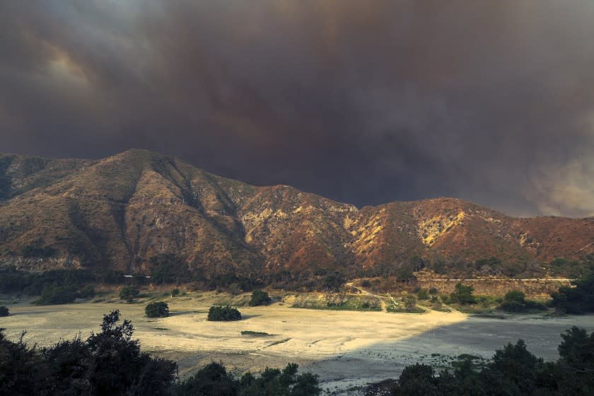
The biggest fire in Southern California, the Bobcat fire in Angeles National Forest, had grown to 36,366 acres with 6% containment as of Monday morning.
On Thursday, officials asked visitors to stay away from Big Bear Lake, Big Bear City, Moonridge, Sugarloaf, Lake Williams, Baldwin Lake, Fawnskin and other communities in the area because of the El Dorado fire. The fire, which started Saturday, had grown to 14,478 acres by Monday morning.
Highway 38 to the mountain resort has been closed just east of Redlands.
A U.S. Forest Service spokesman said forest officials would be assessing risks at each site to decide when to lift the order.
Travelers planning a getaway to any affected areas should check fire status as well as the status of anyplace they plan to visit — local, state and national parks and forests — before they leave home. Checking highway statuses with Caltrans is recommended, as well.
The Dolan fire in Monterey County has forced closure of Highway 1 from Gorda to 6.2 miles north of Slates Hot Springs, shutting down about 30 miles of the coastal route that Southern Californians take to Big Sur, Carmel and Monterey. (Because of that closure, northbound drivers can't reach the Monterey County coast via Nacimiento-Fergusson Road, either.)
The massive Creek fire in the Sierra National Forest, which has grown to more than 175,893 acres, has prompted warnings and evacuations across a wide part of Central California, including popular spots such as Shaver Lake and Huntington Lake.
Forest closures shut down Mammoth Mountain’s bike park, gondola rides, guided climbing and other summer activities. However, the Sierra Star Golf Course and lodgings remain open at the Mammoth Lakes resort.
Hikers with permits heading to Mt. Whitney, the John Muir Trail and the Pacific Crest Trail (where it runs on national forest land) also had to curtail their plans.
At 6 a.m. Tuesday, officials closed Sequoia National Park, citing the risk from the Castle fire, which has now become part of the larger SQF Complex fire.
Meanwhile, Yosemite National Park, less than 50 miles north of the still-uncontrolled Creek fire, remained open to visitors with advance reservations. Rangers did close the park’s Mariposa Grove on Sunday night as a fire precaution.
The southern portion of the park is now under a fire advisory — a possible prelude to evacuation — and spokespeople are warning of poor air quality and visibility. The park's Tioga Road is closed from 10 p.m. to 7 a.m.
Still, said park spokesman Scott Gediman, "all park entrances and facilities remain open. Our best advice is for people to monitor air quality and decide how they want to proceed."
Writer and environmentalist Bill McKibben, tweeting a sepia-toned view of Yosemite’s Half Dome, wrote, “California faces the greatest siege of fire in recorded history.”
Among the 24 locations on the California State Park closure list released late Sunday:
• In Humboldt County, threatened by the Elkhorn fire: Benbow State Recreation Area, Grizzly Creek Redwoods State Park, Humboldt Redwoods State Park; John B. Dewitt Redwoods State Natural Reserve; Richardson Grove State Park; and Smithe Redwoods State Natural Reserve.
• In Mendocino County: Admiral William Standley State Recreation Area; Reynolds Wayside Campground; and Standish-Hickey State Recreation Area.
• In Monterey County, threatened by the Dolan fire: Andrew Molera State Park; Garrapata State Park (on the east side of Highway 1); Julia Pfeiffer Burns State Park; John Little State Natural Reserve; Limekiln State Park; Pfeiffer Big Sur State Park; Point Lobos State Natural Reserve; and Point Sur State Historic Park.
• In San Mateo County, threatened by the CZU August Lightning Complex fire: Butano State Park.
• In Santa Cruz County, also threatened by the CZU August Lightning Complex fire: Big Basin Redwoods State Park (including Rancho del Oso and Little Basin).
• In Santa Clara County, threatened by the SCU Lightning Complex fire: Henry W. Coe State Park.
• In Sonoma County, also threatened by the LNU Lightning Complex fire: Armstrong Redwoods State Natural Reserve; and Austin Creek State Recreation Area.
• In Butte County, threatened by the Northern Complex West Zone fire: Lake Oroville State Recreation Area; Clay Pit State Vehicular Recreation Area.
Besides Mt. San Jacinto, the other three partially closed state parks are: Mono Lake Tufa State Natural Reserve in Mono County; South Yuba River State Park in Nevada County; and Millerton Lake State Recreation Area in Fresno County.
Also, in Point Reyes National Seashore, Limantour Road and many trails, beaches and campgrounds are closed because of the Woodward fire.
This story originally appeared in Los Angeles Times.

