Bryan Norcross: Reasons to be prepared for a busy hurricane season
I'm sure you've heard. The tropics are forecast to be very active this hurricane season. The two main factors we look at both point toward an atmosphere and ocean that would be conducive to storm development.
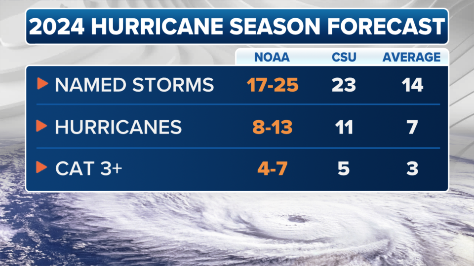
Government forecasters at NOAA are out with their seasonal forecast: 17-25 named storms, 8-13 hurricanes, of which 4-7 are forecast to be Category 3 or above. These numbers are the highest that NOAA forecasters have ever put in their May forecast and are in line with other agencies' predictions.
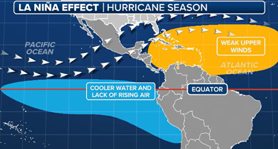
The two reasons for an aggressive forecast are: 1. The extremely warm tropical Atlantic, Caribbean Sea and Gulf of Mexico, and 2. The expectation that a La Niña will develop in the Pacific by the heart of the hurricane season. A La Niña most often produces an upper-level wind regime over the Atlantic that is relatively conducive to storm development.
None of this is absolute, of course. After all, we are talking about what the weather pattern will be months in the future. Even though we have more advanced computer simulations and a better understanding of the mechanisms that generate tropical storms and hurricanes these days, other factors can also come into play, which we can't forecast this far in advance.
The Atlantic water temperatures and the state of El Niño or La Niña explain 70 to 80% of the amount of tropical activity during the season. In 2022 for example, the weather pattern over the tropical Atlantic was hostile to storm development for most of July and all of August despite normally conducive macro factors. This intrinsic uncertainty accounts for the range of numbers NOAA uses to convey their forecast.
And the effect of both key predictors this year is not 100% certain. The La Niña hasn't developed yet, although the scientific consensus is that it will. And the ultra-warm Atlantic might not be all bad.
Since ocean water in the "Main Development Region" east of the Caribbean islands is super warm, more storms should develop there and become stronger while they're in that zone. Storms that strengthen farther east are more likely to turn north because they tend to interact with the jet stream high in the atmosphere.
On the other hand, many of the worst hurricanes in history organized and began strengthening in the Main Development Region. With all that extra energy in the water, if a storm doesn't turn north, it has more time to grow and become a serious problem. So, on balance, the record-warm ocean is not a good thing.
Another issue that adds a layer of uncertainty to how this hurricane season will work out is that no storms have developed in the entire Northern Hemisphere - including the Atlantic and the Pacific - so far this year, which is super unusual and unexpected. There are clearly things going on in the atmosphere that we don't have a handle on. That's not surprising when you think about it because so many aspects of the atmosphere/ocean/climate system are in unprecedented territory. We can't look back at previous years and find analogous situations.
The bottom line, of course, is that everybody in the hurricane zone has to have a plan and know exactly what they're going to do if a storm threatens. Hopefully the big numbers in this year's forecasts well get more people thinking harder about their storm risk and how to handle it.
If you're in South Florida, we used to have a rule. If May is dry, there is a better chance of having a Miami hurricane. We don't talk about that much anymore, but the hot and dry May weather we've been experiencing this year brought that old rule to mind. Think of it as another reason to be prepared.
Original article source: Bryan Norcross: Reasons to be prepared for a busy hurricane season

