Michael forms, can become a hurricane before striking US Gulf coast around midweek
This story is no longer being updated. For the latest forecast information on Hurricane Michael, consult this story.
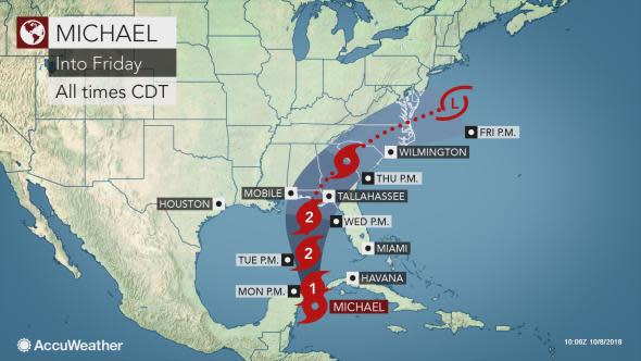
Tropical Storm Michael is expected to strengthen and will put the northeastern Gulf coast of the United States at risk for a landfalling hurricane around the middle of this week.
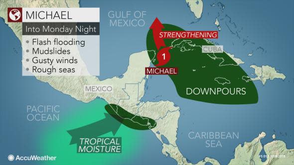
Tropical Depression 14 strengthened into Michael off the shore of Mexico's Yucatan Peninsula on Sunday.
Michael is expected to strengthen further into a Category 2 hurricane prior to making landfall along the Florida Panhandle or perhaps around the Alabama Panhandle.
Florida's Governor Rick Scott declared a state of emergency in northwestern Florida ahead of the storm.
Before reaching the Gulf of Mexico, Michael will bring a threat of flooding rain around the northwestern Caribbean. After landfall, the flood danger will spread over more of the southeastern United States and potentially into the mid-Atlantic and New England later this week.
Heavy rain threat in the northwestern Caribbean, central America
"Through Monday, flooding rain is expected across far eastern portions of the Yucatan Peninsula and far western Cuba," according to AccuWeather Senior Meteorologist Mike Doll.
Wind gusts capable of causing local power outages and minor damage to structures can also threaten these areas as Michael churns northward and strengthens.
Localized downpours may also target the rest of Cuba, Jamaica and Hispaniola into at least Monday. This includes in Haiti where recovery efforts from a deadly earthquake are ongoing.
Moisture streaming in from the Pacific toward Michael can trigger widespread flooding and mudslides in El Salvador and southern Guatemala through early this week.
Michael to strike northeastern Gulf coast around midweek
After emerging into the southern Gulf of Mexico on Monday, Doll anticipates that Michael will track through the central Gulf of Mexico into Tuesday.
Seas will build across the Gulf of Mexico early this week as the storm churns northward, creating dangers for swimmers and boaters well in advance of the storm.
The largest swells and greatest hazards can be anticipated over the eastern and central Gulf of Mexico, but seas can still turn rough along the Texas coastline and at southeastern U.S. Atlantic beaches by midweek.
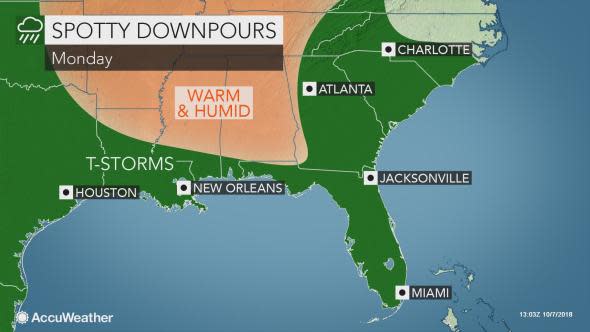
As the seas build, showers and thunderstorms, some of which will be heavy, can also increase across the Florida Peninsula, southern Georgia and northern Gulf coast into Tuesday.
The combination of localized downpours and lightning can disrupt storm preparations in and around the Florida Panhandle.
Rain and wind are expected to ramp up across the northeastern Gulf coast as Michael makes landfall at midweek.
The exact track of the storm will determine whether the heaviest rain and zone of damaging winds focus more toward Alabama or the eastern Florida Panhandle around Wednesday into Thursday.
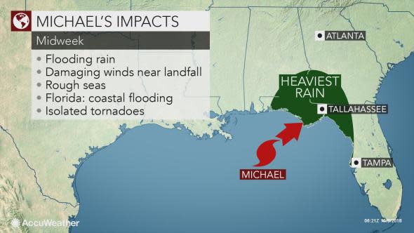
There is also a risk of storm surge flooding and isolated tornadoes near and east of where Michael makes landfall.
Residents in Pensacola, Panama City, Apalachicola, Tallahassee and Cross City, Florida, as well as Dothan, Alabama, are urged to stock up on key essentials, such as non-perishable food, bottled water, medicines and items needed to protect property from damage.
Those in Mobile, Alabama, should closely monitor the progress of Michael.
SEE ALSO:
Leslie finally shows signs of movement in Atlantic Ocean
Resilient North Carolina farmers face substantial recovery after Florence left billions in damage
Sergio to eye western Mexico, southwestern US with flooding downpours late this week
Be sure to keep cell phones fully charged and gas tanks filled. Flight cancellations, as well as school closures and business shutdowns can be anticipated.
Those living in communities at risk for storm surge flooding should have a plan in place in case evacuation orders are given.
Download the free AccuWeather app to stay up-to-date on the latest advisories on Michael and weather hazards for your area.
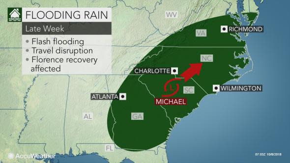
Flood risk to expand across southern, eastern US later this week
The risk of damaging winds will gradually lessen after Michael makes landfall, but flooding rain can continue to expand across the South later this week. Flooding may also threaten the mid-Atlantic and perhaps southern New England.
Michael can deliver a swath of 4-8 inches of rain from the Florida Panhandle into a part of the Carolinas later this week. There can be an AccuWeather Local StormMax™ of 12 inches, mainly across the southern half of this zone.
Such rain can rapidly lead to flooding in low-lying, urban and poor drainage areas. Streams and small rivers can overflow their banks and flood neighboring land and communities. Runoff may lead to eventual rises on larger rivers.
Officials may be forced to close roads or bridges that become flooded or damaged by the flooding. Remember never to drive or walk through flooded roads.
Areas hit hard by Florence may face disruptions to ongoing cleanup efforts or renewed flooding depending on the track of the storm.
If heavy rain unfolds in the southern Appalachians, mudslides can be triggered.
The risk of flooding may become more severe and life-threatening if the storm stalls or moves very slowly over the Deep South-one scenario that AccuWeather meteorologists are monitoring.
The track of Michael and the speed of another non-tropical storm advancing into the East will determine the flood danger for the northeastern U.S. late this week.

Where do you think Michael will make landfall? Play Forecaster Challenge and predict today.
