Break from stormy weather in northeastern US won't last long
The northeastern United States will only get a couple days of dry, sunny weather before the next round of showers and thunderstorms rolls in at midweek.
"In the wake of storms this past weekend, dry air from Canada will allow bright sunshine, a deep blue sky and low humidity by day through Tuesday," according to AccuWeather Senior Meteorologist Alex Sosnowski.
Residents who were not able to complete yard work, construction projects or other outdoor activities due to the frequent downpours this weekend will have an excellent opportunity to do so early this week.
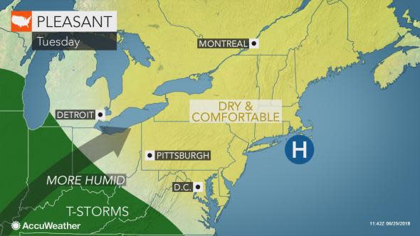
High temperatures generally in the 70s and lower 80s F, along with low humidity, will make for comfortable conditions for most by late-June standards.
The dry spell will end as quickly as it arrived, with people needing to trade sunglasses for umbrellas at midweek.
A storm system will move through the Great Lakes, Ohio Valley and Northeast between Wednesday and Thursday, bringing with it the return of showers and thunderstorms, according to AccuWeather Lead Long-Range Meteorologist Paul Pastelok.
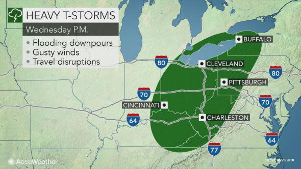
"There can be severe weather," Pastelok said.
Any community that gets hit when thunderstorms are at their peak, during the late afternoon and early evening hours may be hit with damaging wind gusts and torrential downpours.
At this time the flash flood risk is the greatest concern. The risk of flooding will be highest in areas that have been soaked by heavy rainfall recently, including around Pittsburgh.
Streams that receded during the brief dry break may again become swollen.
Secondary roadways could become filled with water, making them impassable to motorists. Travel can also be slowed on area interstates due to reduced visibility.
Those with midweek flights leaving from or arriving at the major hubs in the Northeast should be prepared for delays.
New Englanders may be able to salvage part, if not all of Wednesday, before the stormy weather sweeps eastward into the region by Thursday.
Sweltering heat, humidity to take hold in wake of storms
The passage of the storms will likely mark the beginning of the longest stretch of oppressive heat and humidity so far this year in the Northeast.
The hot stretches in the late spring and early summer have generally lasted three days or less across the region, but this upcoming summer swelter may last five days.
During the end of June and beginning of July, Pastelok anticipates high heat and humidity to bake the Ohio Valley, Great Lakes and Northeast.
"Highs are expected to reach the 90s in many areas, with perhaps a few locations close to 100 degrees Fahrenheit," Pastelok said.
There is a high probability that the intense warmup will be largely dry for most.
