Blizzard keeps I-80, Tahoe shut as snow piles up — ‘If you’re a local, it’s not a big deal’
It was the blizzard that kept on coming — and it continued to aim squarely at the Interstate 80 corridor and Lake Tahoe.
The major east-west corridor remained closed for a second full day and ski resorts were hamstrung to reopen as the effects of a powerful winter storm Sunday continued to plague the Sierra Nevada, and forecasters warned that more heavy snow was on the way for Northern California.
Crews worked through the day to try and clear the massive amounts of snow along I-80, where authorities had abandoned hope Friday night amid howling winds and whiteout conditions. But the walls of snow that clobbered the freeway were making it tough for Caltrans crews.
“Part of the difficulty crews are facing during this storm is blowers breaking down due to the severe conditions,” Caltrans District 3 said in a social media post. “We have been down to 2 of 10 blowers at our central hub in Kingvale and 6 out of 20 from Auburn to the Nevada state line. 80 remains CLOSED with no ETO.”
Personnel at the fortified highway maintenance station have been working in 12-hour shifts to clear the roadway of snow and stranded cars, even having to deal with a power outage themselves after winds nearby clocked in at 190 mph Saturday morning.
Part of the difficulty crews are facing during this storm is blowers breaking down due to the severe conditions. We have been down to 2 of 10 blowers at our central hub in Kingvale and 6 out of 20 from Auburn to the Nevada state line. 80 remains CLOSED with no ETO. @CHP_Truckee pic.twitter.com/EeFWx77xns
— Caltrans District 3 (@CaltransDist3) March 3, 2024
An official with Caltrans told KCRA that the agency did not expect the roadway to reopen on Sunday.
Other mountain roads were closed to all but local traffic and Caltrans worked through the day feverishly to keep Highway 50, the last remaining portal to the Tahoe basin, open albeit with chain controls.
Earlier Saturday, a snow sluff, a small slide of heavy precipitation, sheered off the hillside along Echo Summit, burying the westbound lane in 3 feet of snow.
Caltrans officials told the Tahoe Daily Tribune that sluff was a common occurrence outside the normal avalanche zones because the area around Echo Summit “has steep rocks and sheds snow naturally.”
Here's a video after a snow sluff just east of Echo Summit trapped a few vehicles and closed Highway 50 for about 30 minutes this morning. There were no injuries and crews worked quickly to reopen the roadway. @CHPSouthLake pic.twitter.com/myd5Ay6E32
— Caltrans District 3 (@CaltransDist3) March 3, 2024
The highway was shut down for just about 30 minutes as crews make quick work of the debris; no injuries were reported and chain controls remained in effect Sunday afternoon.
Portions of Highways 20, 49, 89 and 267 remained blocked. The CHP office in South Lake Tahoe warned motorists that tire chains for improved traction were required on most mountain routes. The online warning was accompanied by a photo of a big rig without chains stuck in whiteout conditions on a local road.
“Trying to bypass chain control, no no no!!” the agency said on X, formerly Twitter. “Dangerous and not smart.”
Up at 6,700 feet of elevation near the Tahoe Donner ski resort, Dimitris Sweeney and his brother-in-law Cole Heer, both of San Jose, were still digging to free their SUV from 5 feet of snow after toiling for an hour and a half Sunday morning.
The pair was racing against time to get in as much skiing as possible at Northstar, which had but three runs open by noon. However, the lingering Lake Tahoe blizzard made timing for their returns home uncertain.
“Fingers crossed I’ll be able to leave Wednesday,” said Sweeney, 25, a web designer scheduled to return to work Thursday.
The National Weather Service originally expected its blizzard warning to lapse at 10 a.m., but the storm has persisted longer than expected.
Although meteorologists say the early models held up pretty well in terms of predicting intensity, the storm is not yet over, and forecasters are highly discouraging mountain travel, which they are calling “extremely dangerous to impossible.” Strong winds and additional snow showers are expected through the evening.
Heer, a U.S. Air Force pilot, 29, said he had originally planned to drive back to San Jose next Thursday. With more snow in the forecast for the coming week, he’s now considering hitting the road “whenever there’s a gap to get home,” he said.
“Even where roads aren’t closed, traffic can still be hazardous with all this snow and wind,” said Sarah Purdue, a meteorologist with the weather service’s office in Sacramento.
Significant snow totals continue
Snow totals across the mountains have so far met or exceeded expectations, and mountain communities that were just a month ago at a serious snow deficit are now all but buried.
Meteorologists say colder air from a system off the Gulf of Alaska brought in more moisture from the Pacific, which contributed to the especially high snow totals.
Caltrans officials at Yuba Pass had measured 72 inches of snow around 8 a.m. Sunday, the weather service said. That was double what was recorded Saturday morning.
Other impressive totals as reported to the weather service Sunday:
▪ UC Berkeley’s Sierra Snow Lab — which sits just off Donner Pass Road — had recorded another 23.8 inches after receiving 39.8 inches by Saturday morning: “This takes us to over five feet for this storm so far,” they said of the storm’s totals with reached 63.6 inches.
▪ The weather service said “Soda Springs Caltrans measured 76 inches of snowfall over the last 72 hours. 34 inches measured in last 24 hours.”
▪ Sugar Bowl had measured 87 inches of snowfall at the summit level since the storm arrived. Officials said that “35 inches were measured in last 24 hours at summit level. 63 inches measured at base level over last 72 hours, with 23 inches measured in last 24 hours.”
▪ “Sierra at Tahoe Ski Resort measured 61 inches of snowfall at the summit over the last 72 hours. 26 inches measured at summit in last 24 hours. 50.5 inches measured at base level over last 72 hours. 20 inches measured at base level in the last 24 hours,” the weather service said.
▪ Other remarkable daily (and overall) totals: Kirkwood had 21 inches of new snow (48 inches overall); Bear Valley resort received 30 inches (57 inches total); Soda Springs had 40 inches over a day (84 inches).
The blizzard warning was extended to 4 a.m. Monday for areas above 6,500 feet and a winter storm warning was put into effect for elevations above 3,000 feet through 4 a.m. Wednesday.
While meteorologists said the storm would exit by Sunday evening, another storm was already expected to rake across Northern California as early as Monday.
“A stretch of quieter and more seasonable weather is then expected late week into next weekend,” the weather service said.
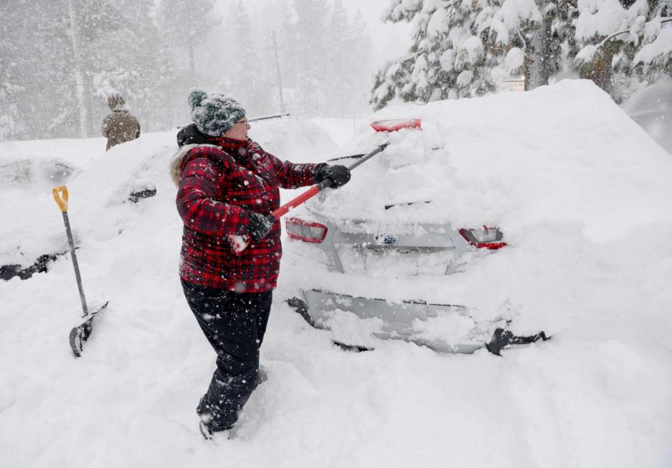
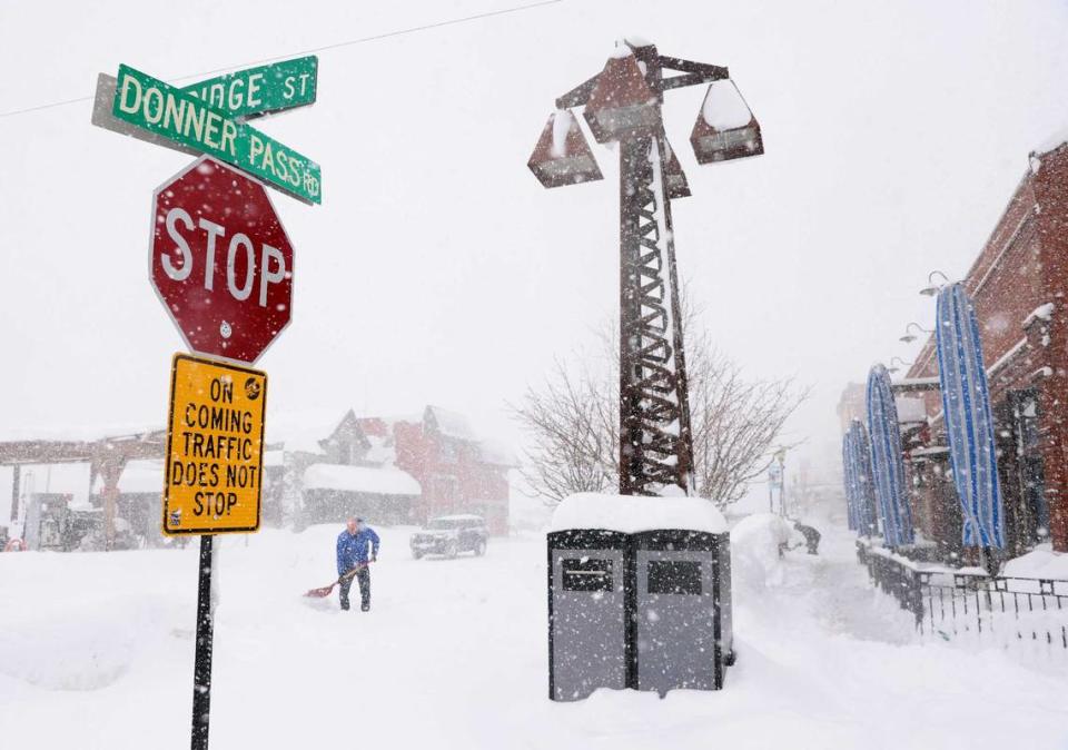
Rudy Islas spent about 40 minutes shoveling his car out before heading to work at a coffee shop in Truckee on Sunday morning. Neither he nor his customers were fazed by the snow, he said.
“To be honest, if you’re a local, it’s not a big deal,” he said. “I think a lot of people are used to the snow and they prepare for it.”
Power outages persist
The storm, as expected, caused significant power outages in the Sierra, which continued Sunday.
According to data collected by the Governor’s Office of Emergency Services, nearly 15,000 customers living in the High Sierra counties — Alpine, Amador, Calaveras, El Dorado, Mariposa, Mono, Nevada, Placer, Plumas, Sierra and Tuolumne — were without power as of 11 a.m. Sunday. That number improved slightly by 3 p.m.
But utility officials cautioned it would be days before everyone might be restored.
“For those of you who have ever shoveled snow, you know that snow is heavy,” said PG&E meteorologist Scott Strenfel. “The weight of the snow is basically weighing down trees in proximity to our lines, also weighing down the assets and causing some of those assets to fail or trees to fall into our lines.”
“It’s also providing challenges just accessing some of these areas because we’re expecting feet on feet on feet of snow and just accessing some of these areas, especially in some of the high winds that we’re seeing too is going to be a challenge,” he said.
Strenfel said the challenges wouldn’t end after the snow stops falling: “We have what’s called unloading and, basically, the snow is going to melt and then it’s gonna fall off trees that can impact our lines again. So we’re looking at continued weather risk.”
Tahoe City and the surrounding area of homes and cabins had nearly 5,000 customers without power Sunday. Other areas like Portola in Plumas County (1,552 homes and businesses) and areas around Tahoma (1,293) were among the largest swaths without electricity.
Kevin Dupui, who lives in Truckee, said his snow blower broke, but it doesn’t really matter because there’s nowhere to put all the snow anyway. “We just move it around,” he said Sunday.
Dupui said residents and tourists seem to be mostly heeding warnings to stay home. “The roads haven’t been that safe, so we don’t really want people driving around,” he said.
Another Truckee resident, Jenelle Potvin, said at first some cynical locals thought “there was a little too much hype” made about the approaching storm. But then the unrelenting snow began Friday night.
“It was definitely a blizzard. And we woke up to a lot of snow yesterday and it never let up,” Potvin said Sunday. Her neighbors were snowmobiling and cross-country skiing in the streets. “But, yeah, we went from 0 to 100 pretty fast.”
Ski resorts still digging out
The blizzard didn’t let up on the constellation of snow resorts across the Sierra, which tried to open but faced considerable odds amid record snowfall.
“We gave it our best shot, but after a monumental effort by our team we’ve made the difficult decision to remain closed for today, March 3rd,” Palisades Tahoe officials said in a social media update. “All lifts have been removed from today’s operating schedule at both Palisades and Alpine.”
Many spots, according to OnTheSnow.com, reported receiving 15 to 30 inches or more of fresh snow over the 24 hours ending Sunday morning. Palisades, home of the 1960 Winter Olympics, reported a three-day total of 6 feet.
“We will be digging out for the foreseeable future,” officials said on the resort’s blog. “There are a lot of steps that go into reopening. Especially when we are starting from scratch.”
Another 31" of snow has fallen in the past 24 hours! That brings the 3-day storm total to an even 6 FEET so far, with one more day to go! Our mountain operations crews have been working hard to reopen and we're now looking at a 12pm opening.
Read more:https://t.co/6KcD7eVaoo pic.twitter.com/L2YU5M4npt— Palisades Tahoe (@palisadestahoe) March 3, 2024
For it and its twin resort, Alpine Meadows, the issue wasn’t just the snow it was the wind.
According to reports, winds topped 190 mph at Palisades Tahoe just after 10 p.m. Friday night while Alpine Meadows recorded a gust of 184 mph. Both gusts were recorded just above 8,600 feet. Strong winds returned Saturday night, but were less severe.
“Though our snowplots were scoured by wind, we estimate we’ve already received up to 5 feet of snow on the upper mountain, and we could see another 2-3 feet by Monday,” Palisades said. “It should be less windy (Sunday), which we are hoping will help us get chairlifts open. Poor visibility has been a scourge these past few days.”
After delays opening its lifts for several hours on Saturday, Heavenly and Northstar had some runs open amid new snow accumulations. On Sunday, operations remained limited in most places.
Bay Area friends Frank McGorman and Michael Shields came up to Tahoe on Wednesday night because they knew the blizzard was coming and they planned to ski plentiful new snow. But too much of a good thing meant nearly all resort skiing was shut down, so on Sunday they broke out their backcountry ski gear to try a trail near Truckee.
“We’re not going to go where it’s steep, for sure, because of avalanche risk,” said Shields, 64, a Los Gatos commercial real estate broker. McGorman, a retired FBI forensic accountant, intended to drive home to San Carlos on Tuesday to help friends with taxes.
On the Western slope, an additional 1 to 2 feet of snow were expected above 4,000 feet until midnight Sunday, with high gusts of wind especially across the peaks. After a brief break in the weather late Monday morning, another storm may bring yet another foot or two of snow by Monday afternoon.
The extended blizzard was forcing McGorman, like Heer, to be flexible on his departure — and be prepared to help his friends remotely. “If there’s a window I’ll take advantage of it,” said McGorman, 70. “If there isn’t, I’ll just stay up and keep skiing.”
Palisades officials had hoped to have some lifts and runs operating by noon, but that plan was scrapped by 10:30 a.m. — officials said they were in no rush to hit the slopes, especially if conditions were not safe.
“We know this is a ton of fresh snow and we are stoked to ski it, too. Remember, we will be open through at least Memorial Day. That’s three months to keep skiing and riding, so you have plenty of time to get out on the hill.”
They echoed the view of local residents, forecasters and emergency personnel: “This storm is NOT over yet.”
The Bee’s Daniel Hunt, the Bay Area News Group and the Associated Press contributed to this story.

