Biggest lake-effect snowstorm in 2 years buries Cleveland area in foot of snow

The pancake-sized snowflakes may have stopped falling, but the lingering darkness from thousands of power outages remain in Ohio and Pennsylvania following meteorological winter's first snow dump of the season.
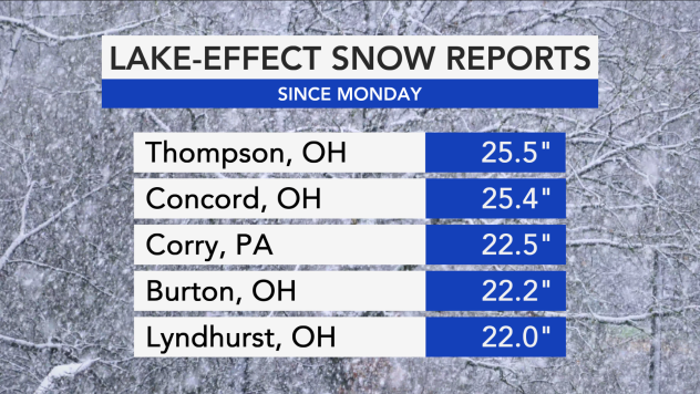
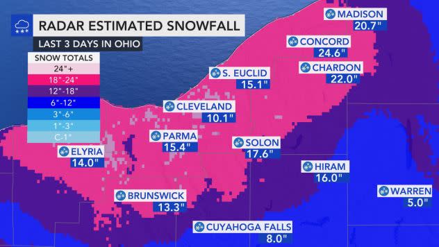
Across parts of Ohio, Pennsylvania, New York and West Virginia, the season's first lake-effect snowstorm unleashed over 20 inches of blanketing precipitation in many areas, topping out at 24.6 inches in Concord, Ohio. The snow sparked travel nightmares on top of the power outages, leaving multiple interstates closed and triggering accidents throughout the region.
As of Wednesday morning, over 50,000 residents between Pennsylvania and Ohio are without power due to the snow.
 |
The National Weather Service issued winter storm warnings and winter weather advisories for parts of Ohio, New York, Pennsylvania and West Virginia as the first lake-effect snowstorm of the season unfolded on Tuesday.
"The system which moved across the Midwest and Northeast brought one of the season's first major snowfalls. This was largely a result of lake-effect enhanced snowfall," AccuWeather Meteorologist Maxwell Gawryla said.
The disruptive snowfall followed a multi-faceted storm that blasted portions of the Midwest and East during Monday and Monday night. In the hardest-hit areas, snowfall totals passed one foot, including areas that have been experiencing below-normal snow so far this season.
 |
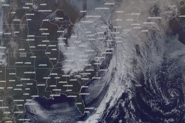
AccuWeather's RealVue satellite shows the large storm pummeling a large swatch of the U.S. |
The core of lake-effect snowfall primarily buried areas downwind of lakes Huron and Erie on Tuesday since a shorter duration of lake-effect snow already occurred off of Lake Michigan late Monday in northwestern Indiana. Shovelers and road crews were busy due to the heavy snow in cities such as Jamestown, New York; Pittsburgh and Erie, Pennsylvania; and Cleveland, Ohio.
"The highest accumulations from this event were observed in northeastern Ohio and northwestern Pennsylvania, just inland of Lake Erie. Several locations have reported snowfall amounts upwards of 12 inches already," Gawryla said.
Thompson, Ohio, recorded the highest snowfall total with 25.5 inches of snow as of Wednesday afternoon.
 |
Shaker Heights, Ohio, located a few miles east of Cleveland, recorded one of the highest snowfall totals with 17 inches, while neighboring Lyndhurst, Ohio, came in close behind with 16 inches. Robbinsville, North Carolina, measured 15 inches that fell during the far-reaching storm that tracked over the region to start the week.
Bands of heavy snow also moved over Pittsburgh, blanketing the Steel City and surrounding areas in a general 4 to 8 inches of snow.
"Very high accumulations were seen in southeastern Ontario where long fetches across Lake Huron brought heavy snowfall through today. Similar to in Ohio, Pennsylvania and New York, as wind directions shift and drier air moves in, snow will slow down and shut off by tomorrow morning," Gawryla said.
Snowfall has been pacing behind normal in the areas that are being buried by lake-effect snow. Just over an inch of snow had fallen in Erie so far this season prior to the lake-effect snowstorm, which is only 13% of the normal 8.7 inches that falls from the start of autumn through Nov. 30. Cleveland has picked up only 0.8 of an inch of snow so far this season, a mere 18% of the normal snowfall through November.
CLICK HERE FOR THE FREE ACCUWEATHER APP
"Matter of fact, this is the first big snow we've had in a couple of years. It's been about 2 years since we got a good snowstorm like this so I'm saying yay," Vic, a snowplow driver, told AccuWeather National Reporter Jonathan Petramala.
The heavy snow weighed down trees, causing some to fall on power lines which sparked more than 57,000 power outages across Ohio Tuesday morning. The outages were concentrated in Cuyahoga, Geauga and Summit counties, according to News 5 Cleveland. The Chardon Fire Department reported multiple trees and wires are down in Geauga County due to wind and heavy snow.
Heavy, wet, sticky snow and a lot of trees are sagging or snapped NE of #Cleveland where the #snow is definitely deeper. @accuweather @breakingweather pic.twitter.com/pkAL3UXxgQ
— Jonathan Petramala (@jpetramala) December 1, 2020
"Fallen limbs may end up covered in snow on roadways. Do not go out today unless you absolutely must," The Chardon Fire Department tweeted.
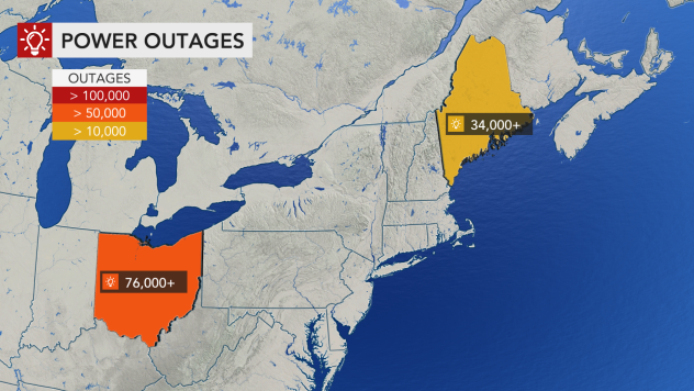
Power outages mounted to 76,000 in Ohio Tuesday evening as the storm progressed. Maine's power outage numbers were around 34,000, according to Poweroutage.us, due to the early-week storm that lashed the state with strong winds.
 |
Due to the amount of snow and inclement weather, the city of Cleveland issued an emergency parking ban starting at 8 p.m. on Tuesday. Parking will not be allowed on any street marked with a red and/or white restriction signs until 8 a.m. on Wednesday.
Among the parking restrictions, Heinen's supermarket closed all of its Ohio stores at 5 p.m. on Tuesday for the safety of their customers and associates.
False
Adding to extensive school closures amid coronavirus, Cleveland State University canceled in-person classes on Tuesday along with other schools in the region.
The City of Cleveland announced waste collection was delayed on Tuesday and for the rest of the week by one day.
"Our waste collection trucks can't reach side streets due to the intensity of the snow. At noon, we will begin to plow side streets. We'll continue to post weather updates here," the city said on Tuesday.
Say a prayer if you are trying to make it up a hill on a side street around #Cleveland #ohwx #snow @accuweather @breakingweather pic.twitter.com/yoly8YVtqc
— Jonathan Petramala (@jpetramala) December 1, 2020
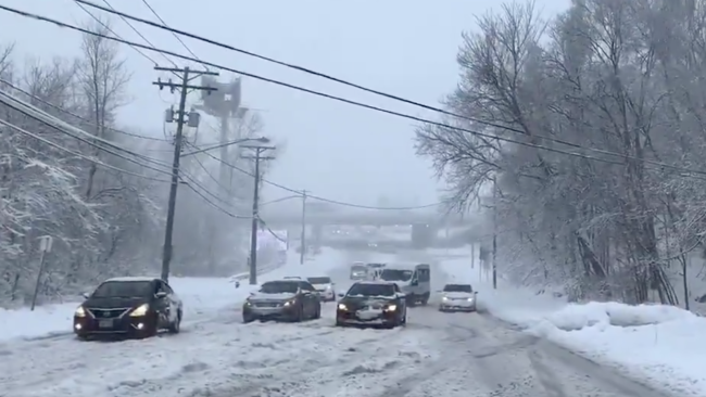
The storm unloaded wet snow that partially melted on some roads which lead to slushy conditions. However, in other areas, the intense rate of snow during the squalls and lake-effect snow bands caused the snow to pile up quickly in some locations.
The National Weather Service in State College, Pennsylvania, asked motorists to use caution while traveling, especially in the northwest mountains and Laurel Highlands. AccuWeather meteorologists also warned motorists of the winter weather conditions who were traveling along stretches of interstates 70, 76, 79, 80 and 90 in western Pennsylvania, as well as interstates 80 and 90 in northeastern Ohio and interstates 86 and 90 in western New York.
Snowfall triggered sudden changes in visibility and covered roads with snow in Cleveland, Ohio. Video taken on Tuesday morning from the National Weather Service building in Cleveland shows blowing and drifting snow near interstates 480 and 77. Moderate to heavy snow continued throughout the day across much of the Cleveland metro area.
Video from our rooftop at #NWS #Cleveland near Interstate 480 and 77 this morning. Moderate to heavy snow continues across much of the #CLE metro area. The higher elevations and Heights are getting the worse of if this morning.#OHwx #PAwx #ThisIsCLE #Winter #Weather pic.twitter.com/zCU8UQS1uT
— NWS Cleveland (@NWSCLE) December 1, 2020
The Ohio Department of Transportation (DOT) reported many road closures while 200 crews were trying their best to keep up with clearing the roads throughout southwest Ohio. Sections of I-70 in Preble County were closed due to a crash. I-480 westbound spur near Rockside Road. also closed due to an accident.
"Even though the snow has stopped, crews are battling drifting and windy conditions," the Ohio DOT said.
Our drivers are working through their 12-hour shifts to help fight through the continuing snow fall. Photos below from I-71, I-271, I-480 and U.S. 422.
Please don't crowd the plows. #ODOTwinter pic.twitter.com/qMwqdOgVO4— ODOT Cleveland (@ODOT_Cleveland) December 1, 2020
Milder air is forecast to flow eastward from the Plains and Midwest during Thursday and Friday, allowing some of the snow to melt.
Forecasters noted that, even though the wintry weather has ended, areas of ice could develop during the nighttime and morning since temperatures will dip below freezing.
Keep checking back on AccuWeather.com and stay tuned to the AccuWeather Network on DirecTV, Frontier and Verizon Fios.
