Beaufort, Jasper counties under tornado watch Wednesday. Here’s what we can expect
The National Weather Service issued a tornado watch for Beaufort and Jasper counties Wednesday morning that is expected to lift at 1 p.m.
A tornado watch means tornadoes are possible in and near the watch area, according to the NWS. The service added that the watch area is large, covering multiple counties or states.
If the service later issues a tornado warning, that means a twister has been sighted or shown on weather radar, meaning there is imminent danger to life and property. Local forecast offices issue warnings, which generally are in small areas — about the size of a city or small county.
Severe weather that swept across the nation Monday and Tuesday pummeled states with flooding, heavy mountain snow and destructive hail, and brought threats of tornadoes.
On Wednesday, the Lowcountry could see widespread showers and thunderstorms before a cold front moves into the area, the service’s Charleston Office said. During the storms, wind gusts could whip as high as 60 mph, leading to tree and power line damage.
As of 8 a.m. Wednesday, there were no customers in Beaufort and Jasper counties without power, according to PowerOutages.us.
“While the storms will bring downpours with them, the flooding risk is minimal, because the rain won’t be long-lasting,” said Frank Strait, the state’s severe weather liaison.
Outside of thunderstorms, breezy conditions will blow through Beaufort and Jasper counties, with wind gusts up to 30 mph. Hail of 1/4 inch is possible.
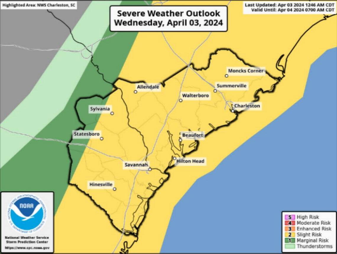
According to the NWS Charleston Office’s map, the Lowcountry is at a “slight risk” for its severe weather predictions, meaning scattered and severe thunderstorms are possible but will be short-lived and isolated.
Risk for severe weather should end by early afternoon as activity pushes offshore, the service said Wednesday morning. Strait said behind the storms, the rest of Wednesday and Thursday will remain blustery, but the winds should not be high enough to cause damage.
“However, this is enough to blow around loose items in your yard, so get that stuff stowed ... before the storms hit and keep them secure until the winds settle down on Friday,” Strait said. “Also, motorists should be ready for annoying crosswinds on both days.”
Tornado safety
During a watch, the NWS encourages people to discuss emergency plans, check supplies and a safe room. Below is a list of needed supplies.
Water
Food, and pet food if applicable
Battery-powered or hand crank radio and a NOAA Weather Radio with tone alert
Flashlight
First aid kit
Extra batteries
Whistle (to signal for help)
Dust mask (to help filter contaminated air)
Plastic sheeting and duct tape (to shelter in place)
Moist towelettes, garbage bags and plastic ties (for personal sanitation)
Wrench or pliers (to turn off utilities)
Manual can opener (for food)
Local maps
Cell phone with chargers and a backup battery
During a warning, the NWS says to take action. For safety, move to an interior room on the lowest floor in a sturdy building. Do not go near windows. If a person is in a mobile home, inside a vehicle or outside, they should seek the closest shelter and find protection against flying debris.
Get as low as you can.
Put as many walls between yourself and the outside as possible.
Avoid windows. Do not wait to seek shelter until you see or hear the tornado.
Do not take time to open or close windows and doors. It will not protect the structure. In homes or public buildings, go to the basement or a small interior room.
Close all doors to the hallway.
Get under something sturdy such as a heavy table.
Protect yourself from flying debris with pillows, heavy coats or blankets.
Use a helmet to protect your head.
In mobile homes, leave in advance of the approaching severe weather and go to a strong building.
If there is no shelter close, get into the nearest ditch, low spot or underground culvert.
Lie flat and cover your head with your hands for protection.
In vehicles or outdoors, when tornadoes are possible, limit your outdoor plans or finish them early.
Stay close to a sturdy shelter.
Do not take shelter under a highway overpass. Wind speeds can increase due to a tunneling effect.

