B.C.’s weekend holds plenty of rain, heavy snow, and avalanche risks
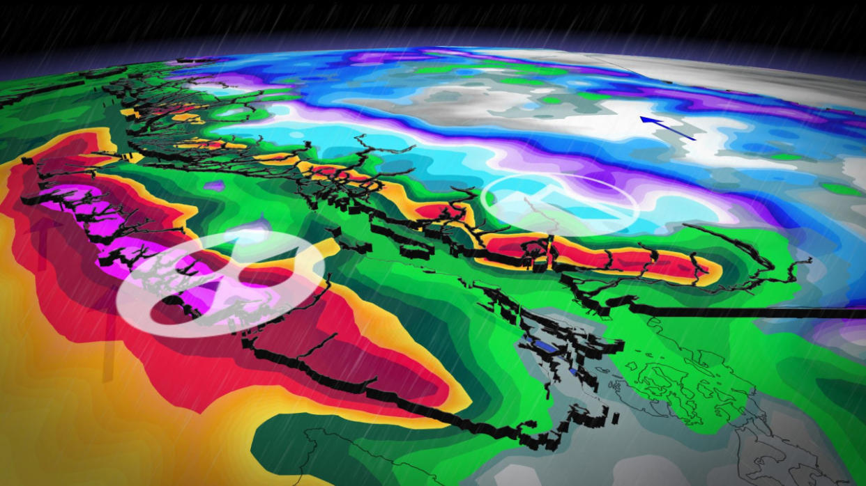
It’s an active weekend on the West Coast as a productive storm track sends one system after another careening into British Columbia.
Persistent rounds of low-elevation rain and heavy alpine snow will add up through the weekend and even into next week. While this will be great news for ski areas that are embracing the recent hefty totals, it could also lead to slippery and dangerous travel conditions on mountain passes through the weekend.
MUST SEE: How 10 days turned the entire B.C. ski season around
Rain and gusty winds persist this weekend
Rain will build over Vancouver Island and the South Coast on Saturday and continue straight through the weekend.
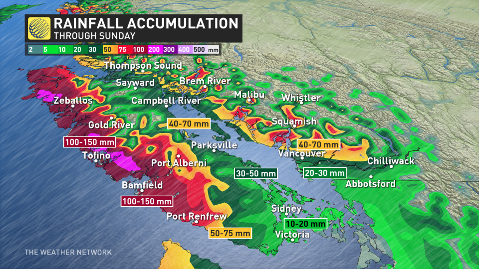
Widespread rainfall totals of 30-50 mm are expected throughout the region, with totals of 40-70 mm possible north of Metro Vancouver. Western Vancouver Island will take the brunt of the heavy rain with totals reaching 100-150 mm through Sunday.
Environment and Climate Change Canada has issued several rainfall warnings and special weather statements for Vancouver Island and the Metro Vancouver area ahead of these systems.
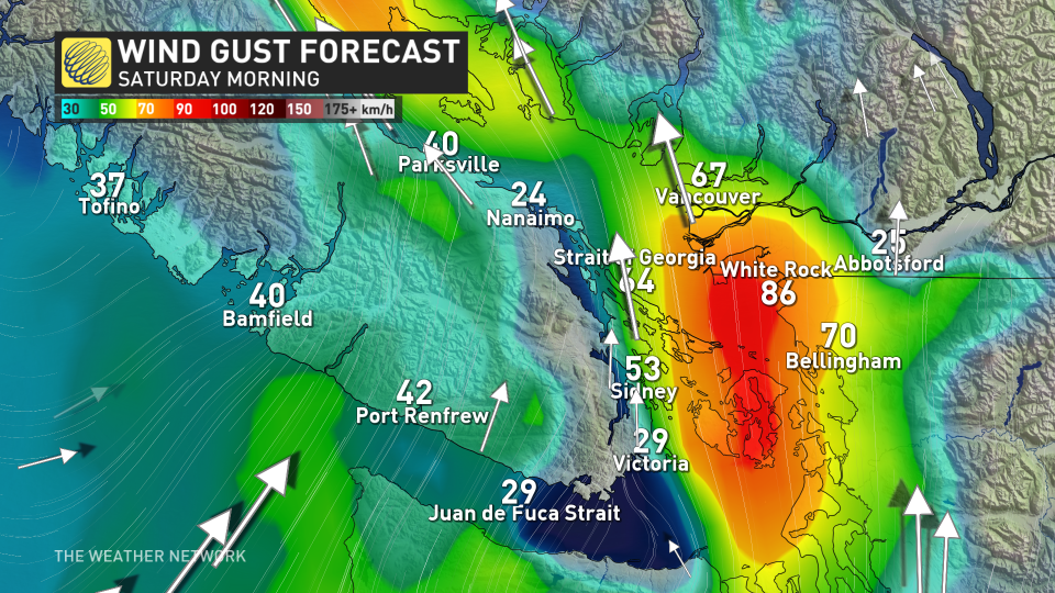
Gusty winds will accompany the heavy rain at times. A brief round of gusty southerly winds will sweep into the Strait of Georgia on Saturday morning, bringing gusts of 70+ km/h at times.
These same areas could see another round of gusty winds with the next system’s arrival on Sunday.
Heavy snow hammers the Coast mountains
While folks at lower elevations contend with persistent rains, snow will continue this weekend for elevations above 1000 m. We might see freezing levels drop a bit over the next day or so.
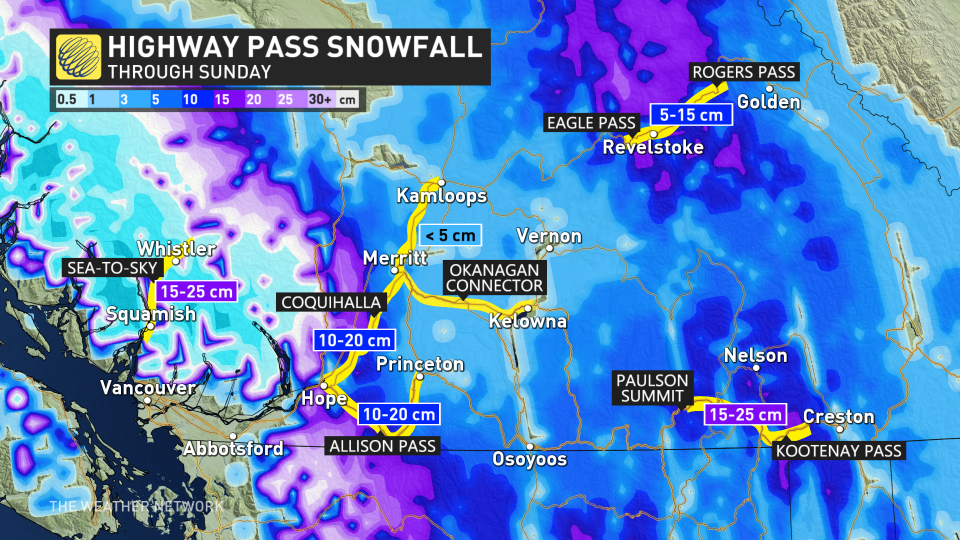
Farther inland, we’ll see snow build across the Interior through the weekend. Heavy snow is possible by Sunday evening.
Snow accumulation could vary greatly depending on the intensity of precipitation as well as the temperatures. Regardless, the threat for 40-70+ cm across the hardest-hit areas will make for difficult travel conditions throughout the weekend.
Folks travelling along Highway 99 between Howe Sound and Whistler may experience slippery roads. Drivers are urged to consider postponing any non-essential travel until conditions improve.
RELATED: What recent snowstorms mean for the drought and wildfire risk in Western Canada
This round of unsettled weather will make for dangerous avalanche conditions across B.C. this weekend.
A high avalanche danger exists for much of the South Coast, Vancouver Island, and portions of the Interior into Sunday. Avalanche Canada issued a Special Public Avalanche Warning for Banff, Kootenay, Yoho National Parks, and Kananaskis Country through the end of the day on Sunday.
Looking ahead, rounds of rain and snow will continue for southern B.C. through the start of the week. A much milder and drier pattern is set to take shape by the middle of the month and continue well into the second half of March.
