Atmospheric river to wallop Northwest to start December with flooding rain, feet of snow


Following a relatively dry end to the month of November, December will start out significantly soggier in the Northwest as a series of storms will bring multiple rounds of heavy rain, snow and gusty winds to the region, warn AccuWeather meteorologists.
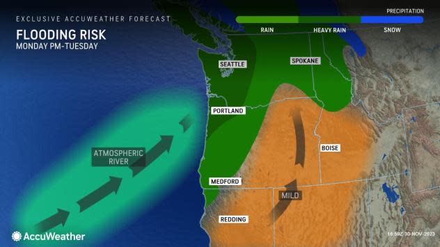
The storms will arrive via an atmospheric river, a meteorological phenomenon where a flow of moisture from the Pacific Ocean resembles a fire hose that delivers near-constant rain and higher-elevation snow to the western United States or British Columbia.
"This particular atmospheric river setup extends for more than 7,000 miles from all the way across the Pacific Ocean to the northern part of the Indian Ocean basin," AccuWeather Senior Meteorologist Mike Doll said.
 |
"A series of storms will come ashore in the Northwest late this week," said AccuWeather Senior Meteorologist Heather Zehr. "Additional storms will carry on even into next week."
As the pattern persists through at least the middle of next week, impacts from the storm train at the coast and for lower elevations inland will include travel delays and flooding from downpours, as several inches of rain will fall. Farther inland over the mountains, heavy snow can snarl travel at pass level then can suddenly melt and lead to flooding and avalanches, due to fluctuating temperatures.
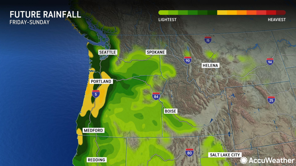
Rain is forecast to continue across western Washington and Oregon, as well as far northwestern California through early next week. Farther inland, snow will break out in the mountains, due to the chilly air. Both types of precipitation will continue more or less ceaselessly and at varying rates into the weekend.
 |
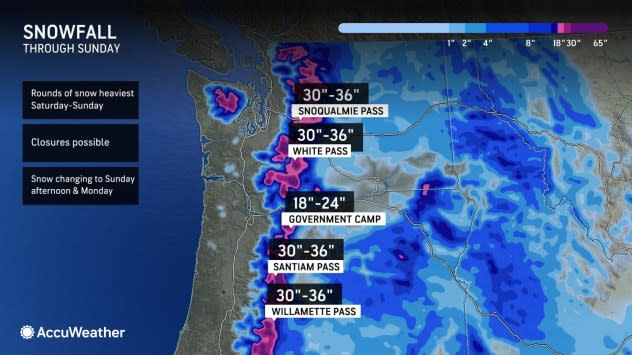
"These storms will be accompanied by cold air at first," added Zehr. "Through the weekend, snow levels will be down below 2,000 feet at times, leading to accumulations of 2-3 feet and major travel impacts in the Cascade passes."
In the cities along the Interstate 5 corridor, including Redding, California; Eugene, Medford, Portland and Salem, Oregon; and Olympia, Seattle and Tacoma, Washington; it will be too warm to snow, but rain can reach an inch or two inches in rain gauges through Sunday.
 |
Near the coast, Zehr warns that there can be more. "The coast and coastal mountain ranges will end up with 4-8 inches of rain," she said. "Widespread flooding is likely in these harder-hit areas."
Strong, gusty winds in the range of 40-60 mph will accompany the rain along the Pacific coastline, which can lead to minor damage, impact travel for high-profile vehicles and even toss around holiday decorations. Along the I-5 corridor, winds will be lighter but strong enough to add a raw feeling during the rain with temperatures mainly in the 40s.
 |
The heavy rain and mountain snow into the weekend can be considered the first phase of the storm train in the region, as the tenor of the storminess will change markedly from late in the weekend into next week, especially over the higher terrain.
"By early next week, warmer air will return northward, and snow levels will rise considerably as the storminess continues," said Zehr. "This will not only add to the flooding risk near the coast but also introduce that risk in the Cascades as the snow dropped by earlier storms melts, with additional rain on top of that contributing to the threat."
The rising snow levels could begin as early as Saturday in the Oregon Cascades and Sunday in the Washington Cascades. Through the middle of next week, the precipitation should fall as mainly rain in the mountain crossings, including through Barlow, Blewett, Snoqualmie, Stampede, Stevens and Willamette passes.
 |
Not only does the warmer weather present a flooding risk from melting snow and heavy rain, but there also can be an avalanche risk, as the existing snowpack will become more unstable on steep mountain slopes as it fills with the weight of rainwater. Hikers and other outdoor recreators in the higher grounds of the Northwest should exercise extreme caution and consider waiting to go out until the conditions improve.
Through at least the middle of next week, rain will also continue to soak Portland, Seattle and the rest of the coast and lower elevations. Several more inches of rain will pile up in rain gauges before the weather pattern may change toward the end of next week. By that point, some locales may have received over a foot of rain.
 |
The wet weather to start December will be in stark contrast to how November ended in Seattle and Portland but similar to how that month started. From Nov. 1-14, 5.09 inches of rain fell at Seattle-Tacoma International Airport, which is 177% of the historical average, while 4.45 inches was recorded at Portland International Airport, 186% of the average. In the two weeks that then followed from Nov. 15-28, only 0.55 of an inch fell in Seattle and 0.58 of an inch in Portland, well below the historical average for that period.
The incoming moisture, while carrying several threats, is not all bad news-it will help to relieve drought conditions in the region. According to the latest U.S. Drought Monitor released last week, 77% of Washington and 65% of Oregon were considered at least abnormally dry, with just under half of the land in both states considered to be in drought.
Want next-level safety, ad-free? Unlock advanced, hyperlocal severe weather alerts when you subscribe to Premium+ on the AccuWeather app. AccuWeather Alerts™ are prompted by our expert meteorologists who monitor and analyze dangerous weather risks 24/7 to keep you and your family safer.
