Atmospheric river to soak the Northwest, raise flood risk through the end of January


The first month of the year will end as it started in the Pacific Northwest - on a very soggy note - as a series of storms will bring heavy rain and a risk of flooding to the region over the next week, warn AccuWeather meteorologists.
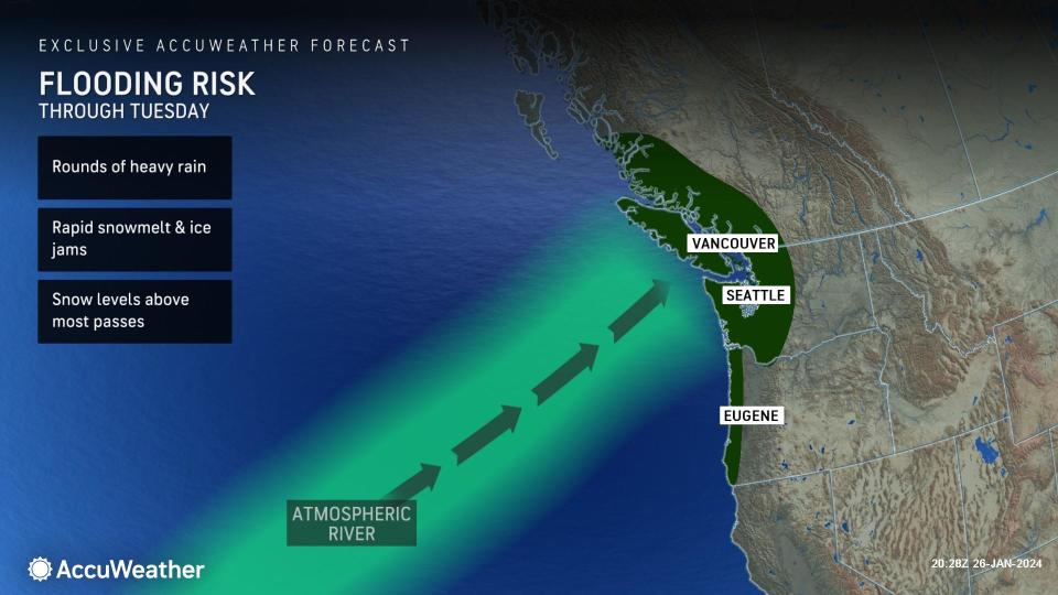
The storminess will come via an atmospheric river, a continuous flow of moisture that will extend from the Pacific Ocean into the northwestern United States and British Columbia, Canada. It will result in relentless rain events, which could unload over a foot of rain in some areas by the end of January.
Most of California will miss out on this atmospheric river, just days after San Diego experienced its wettest January day on record, with rain leading to flooding and mudslides and triggering a state of emergency declaration. Instead, the lion's share of the moisture will be focused on Oregon and Washington state and adjacent parts of southwestern Canada.
 |
"A strong area of high pressure building in the upper levels of the atmosphere will push the storm track well to the north," said AccuWeather Senior Meteorologist Heather Zehr. "This will aim it mainly into western parts of Oregon and Washington, as well as British Columbia."
It will be a continuation of what has been a soggy month along the Interstate 5 corridor. In Portland, 9.25 inches of precipitation, mainly in the form of rain, has fallen this month as of Jan. 27, well above the historical average of nearly 4.50 inches for that timeframe. It hasn't been quite as wet in Seattle, but the total monthly rainfall is approaching 6 inches as of Saturday, and the Emerald City might end up being the wetter of the two cities by the end of the month.
 |
Through the start of the weekend, a broad area extending across Oregon and Washington, especially from the Cascade mountain range to the coast, bore the brunt of the heaviest rain. Into the early part of this week, the atmospheric river will become more targeted into northwestern Washington and Canada.
"The heaviest rain is likely to fall over the Olympic Mountains, as well as Vancouver Island and southwestern British Columbia," said Zehr. "Some places can pick up a foot of rain or more with persistent rounds of heavy rainfall over the same area over several days."
Lighter amounts of rain, on the order of a few inches, can be expected along the I-5 corridor around Olympia, Seattle and Tacoma, but Vancouver may experience higher amounts of 5 inches (about 125 mm) or more. Rainfall of this magnitude can easily cause flooding.
"Flooding is likely, not just because of the heavy rain but also due to higher snow levels that will be above most passes," pointed out Zehr. "This will lead to snowmelt of some heavy snow that fell during the cold snap earlier in the month."
 |
Snow levels are the elevations where rain changes to snow. For much of the atmospheric river event, it will be above where most people live and drive, perhaps as high as 8,000 feet, which is somewhat unusual for the middle of winter. The milder air accompanying the storminess can also lead to ice jam flooding on rivers in the Northwest.
Quieter weather is expected to return to the region by the middle of next week due to a change in the weather pattern.
"The worst of the rain may finally end after Wednesday, as the high-pressure area blocking the storms from pushing inland begins to shift to the east," added Zehr.
Want next-level safety, ad-free? Unlock advanced, hyperlocal severe weather alerts when you subscribe to Premium+ on the AccuWeather app. AccuWeather Alerts™ are prompted by our expert meteorologists who monitor and analyze dangerous weather risks 24/7 to keep you and your family safer.
