'Potentially historic' storm bringing thundersnow, blizzard conditions, downpours to 200M
FORT COLLINS, Colo. – A "potentially historic" storm driving blizzard conditions and thundersnow roared throught the region Wednesday, a massive weather system that will fuel downpours, high winds and possibly tornadoes as it heads east.
The storm threatens 200 million Americans over the next couple of days, a blockbuster follow-up to the "bomb cyclone" that blasted the region last month.
"A potentially historic storm (is) bringing a variety of precipitation types, strong wind gusts in excess of 50 mph, and very heavy snow totals," the National Weather Service in Minneapolis warned. "Prepare now for a severe winter storm."
Parts of South Dakota and Minnesota could see more than two feet of snow, the weather service said. Some areas were being blasted by snowfall rates of two inches per hour. The weather service also reported "thundersnow" – thunder and lightning accompanied by snow instead of rain.
“We’re calling it historic because of the widespread heavy snow. We will set some records,” said Mike Connelly, a weather service meteorologist in Aberdeen, South Dakota.
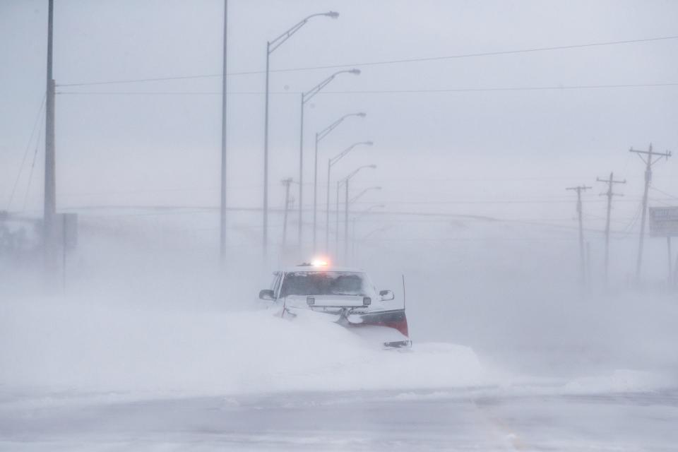
In Northern Colorado, some areas could see up to eight inches of snow and wind gusts approaching 70 mph, the weather service said.
Late Wednesday, Colorado state climatologist Russ Schumacher said in a tweet that the storm can be classified as a "bomb cyclone," the region's second in a month.
The first "bomb cyclone" – a rapidly intensifying weather system – hit March 13, dropping heavy snow and leaving dozens of vehicles stranded on local highways in whiteout conditions.
Start the day smarter: Get USA TODAY's Daily Briefing in your inbox
In a rite of spring for Colorado, temperatures in Fort Collins plummeted from Tuesday's high of 77 degrees to the 20s by Wednesday night, the weather service predicts.
AccuWeather meteorologist Alex Sosnowski warned that the snow will be heavy and wet, and difficult to plow and shovel. Travel will likely be snarled as airports and highways struggle under the burden.
More than 700 flights into and out of Denver International Airport were canceled Wednesday and more than 160 were already canceled for Thursday. The Colorado State Patrol warned would-be travelers to consider delaying road trips.
"We strongly encourage employers to consider either fully canceling work today, or at least allow employees a half day and to go home by noon," the State Patrol said on Twitter. "The fewer cars on the road during bad weather, the better."
Start the day smarter: Get USA TODAY's Daily Briefing in your inbox
Blizzard conditions from what the Weather Channel has dubbed "Winter Storm Wesley" – even though it's spring – were also poised to blast through parts of Wyoming, Nebraska, Kansas. To the east and south, thunderstorms and high winds threatened areas recovering from recent flooding along the Missouri and Mississippi rivers.
As is often typical for big storms in the central U.S. in April, crazy temperature contrasts were recorded in a few states Wednesday. For instance, while the temperature was 27 degrees in western Nebraska in Scottsbluff, it was 78 degrees in Falls City in far southeastern Nebraska.
"Heavy snow and strong winds will produce life-threatening travel conditions in parts of the Plains and Upper Midwest," the National Weather Service warned. "The heavy wet snow may also lead to power outages."
AccuWeather said parts of Minnesota can look forward to up to a foot of snow and sleet through Thursday and into Friday.
On Thursday, parts of Missouri, Iowa, Illinois, Indiana, Kentucky and Tennessee could face "damaging" wind gusts, large hail, heavy rain and possibly tornadoes, AccuWeather said. Indiana and Illinois are at greatest risk for severe weather Thursday, the Storm Prediction Center said.
Following the storm, the melted snow will only exacerbate the flood threat across the north-central U.S. over the next few weeks.
And even though New Mexico and western Texas will miss out on the snow, howling winds gusting as high as 90 mph will create a high risk of wildfires. The White Sands Missile Range in Southern Mexico shut down, citing "extreme winds."
"Dangerous west winds developing today south and east," the weather service in Albuquerque tweeted. Strong crosswinds will impact travel on north to south oriented roads including I-25. Critical fire weather Middle Rio Grande Valley eastward."
Bacon and Rice reported from McLean, Va. Contributing: The Associated Press
This article originally appeared on USA TODAY: 'Potentially historic' storm bringing thundersnow, blizzard conditions, downpours to 200M

