Another round of severe, drenching storms to target southern US into Sunday night
As a second storm in three days pushes east of the Rockies, severe and drenching storms will erupt across areas from the southern Plains to the Southeast to close out this weekend.
Three separate areas of severe thunderstorms are expected to ignite. One area will track from Alabama to northern Florida; a second will target communities from near Dallas to Shreveport, Louisiana; the third will rattle Kansas and north-central Oklahoma.
All residents should stay alert for changing weather conditions, monitor cell phones and other devices for vital warnings and be ready to seek shelter.
The greatest risk for severe thunderstorms will lie from around the central border of Texas and Oklahoma to northern Louisiana into early Sunday night. These thunderstorms can be capable of producing all facets of severe weather from damaging winds, large hail, frequent lightning and isolated tornadoes.
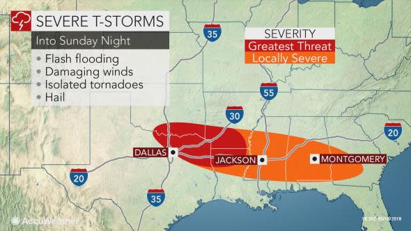
As with any robust thunderstorm, there is the risk of localized flash and urban flooding.
The thunderstorms could threaten the soccer match between FC Dallas and Seattle Sounders in Frisco, which is located north of Dallas, late Sunday.
Meanwhile, thunderstorms will also track from Alabama to northern Florida to close out the weekend. The majority of these thunderstorms will unload heavy rain and locally damaging winds.
Localized flash flooding can occur within the corridor from Montgomery and Mobile, Alabama, to Pensacola, Florida, and Albany, Georgia.
Motorists planning to travel on stretches of interstates 10, 20 and 65 should use caution as downpours can reduce visibility and dramatically heighten the risk of vehicles hydroplaning when traveling at highway speeds.
Meanwhile, areas from north-central Oklahoma to central Kansas may experience storms with large hail and lightning that can touch off new wildfires where it is not raining.

South of these thunderstorms, strong non-thunderstorm winds will whip New Mexico and West Texas into Sunday evening. These winds can create a variety of dangers to residents and motorists ranging from power outages, an extreme fire danger and blowing dust.
Dangerous crosswinds threaten to overturn high-profile vehicles, especially those traveling on north-south running roads.
"In order for there to be a major outbreak of severe thunderstorms over the southern Plains, first the landscape will have to be moistened up," according to AccuWeather Storm Warning Meteorologist Richard Schraeger.
Moisture in the ground then evaporates into the lower atmosphere. Severe thunderstorms require a certain amount of moisture to develop.
Much of the southern Plains has been experiencing severe to exceptional drought this winter.
In the wake of Sunday's severe weather, additional violent thunderstorms will focus on the Southeast from Tennessee to Florida Monday into Tuesday.
