America’s newest weather satellite sends glorious pictures of Earth (and the moon)
Two months after its launch, the National Oceanic and Atmospheric Administration’s GOES-16 weather satellite is sending back its first images – and they’re spectacular.
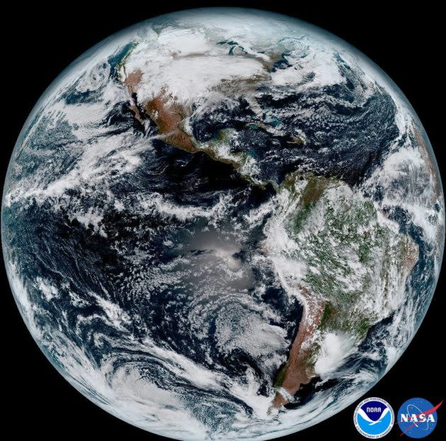
GOES-16 is watching the Western Hemisphere from a geosynchronous orbit 22,300 miles above Earth, with a camera known as the Advanced Baseline Imager that provides four times the resolution of previously launched GOES satellites.
In a news release accompanying the first pictures, NOAA says the higher resolution should allow forecasters to pinpoint the location of severe weather with greater accuracy.
The imager scans Earth’s disk five times faster than the earlier generation of GOES cameras. That allows it to produce pictures of the continental U.S. every five minutes, and full-disk views every 15 minutes.


“One of our GOES-16 scientists compared this to seeing a newborn baby’s first pictures – it’s that exciting for us,” Stephen Volz, director of NOAA’s Satellite and Information Service, said in today’s release. “These images come from the most sophisticated technology ever flown in space to predict severe weather on Earth.”
NASA will position GOES-16 to focus either on the western U.S. and the Pacific, or the eastern U.S. and the Atlantic. That decision is due to be announced in May, and the satellite should be operational as either GOES East or GOES West by November.
The second in a set of four next-generation weather satellites, currently known as GOES-S, is currently undergoing testing in preparation for launch in 2018. If GOES-16 goes East, GOES-S will go West, and vice versa.
More from GeekWire:
Moon photobombs Earth in amazing video from DSCOVR satellite
Hurricane Patricia looks scary from space: Satellites track storm as it menaces Mexico
Doubleheader in space! Trio arrives at space station, weather satellite lifts off
NASA shows off greatest hits from DSCOVR satellite’s year of watching Earth
