Amazing photos show a UFO cloud hovering over Mount Etna
Breaking news: Aliens are invading Earth after landing on top of a volcano in Sicily.
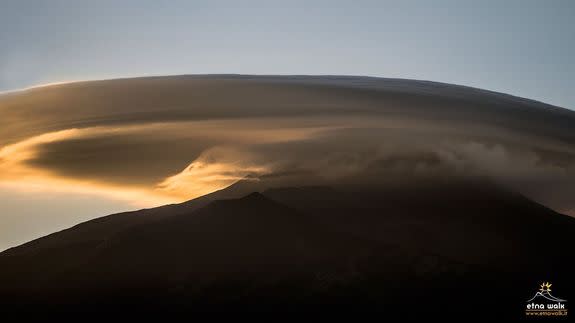
Or at least that's what the pictures of an unusually pronounced version of a particularly rare cloud make it seem like. Posted to the World Meteorological Organization's Facebook page as well as other social media sources, the photos show a massive lenticular cloud perched atop Mount Etna on June 14.
SEE ALSO: These cloud maps track life on Earth in beautiful detail
In these pictures, the cloud appears to be enshrouding the peak, and looks like a stack of pancakes above the volcano.
Such clouds are known for creating dramatic scenes, but this altocumulus standing lenticular (from the Latin word "Lenticularis," meaning "like a lentil") is especially striking.
Here's how the American Meteorological Society (AMS) defines lenticular clouds in it's Glossary of Meteorology:
"A cloud species the elements of which have the form of more or less isolated, generally smooth lenses or almonds; the outlines are sharp and sometimes show irisation."
The AMS states that the clouds typically form from the airflow over terrain features, such as mountains.
Lenticular clouds such as these usually form when there are strong winds blowing at high altitudes, and as moist air is forced to go up and over mountains.
As the air rises in this way, which is known as orographic lifting, it is forced to cool and condense into clouds. Such clouds are then shaped by the strong winds and contorted by the mountain-induced wave in the airflow.
These clouds form in much the same way as rocks cause standing ripples in streams.
The lenticular cloud marks an area of rising and then sinking air, and glider pilots will often use these clouds as clues to where to catch the best lift. The area downwind of a lenticular cloud features sinking air, and sometimes, a line of lenticulars can form as the waves in the air progress downstream.
This often happens in the lee of the Rocky Mountains near Denver, and can be associated with turbulence approaching that airport.
