From alpine snow to thunderstorms: B.C.'s inbound, wild weather ride

A punchy frontal system is sliding across British Columbia this week, bringing a bit of spring and winter weather to the province.
The system will feature gusty winds, heavy rainfall, a risk of thunderstorms and even mountain snowfall. The rain and snow is much-needed to help quench the wildfire threat in the province, which is still reeling from some intense drought conditions in some areas.
CANADA'S WILDFIRES: Visit The Weather Network's wildfire hub to keep up with the latest on the active start to wildfire season across Canada.
More than 30 mm of rainfall was reported across portions of the Lower Mainland through Tuesday afternoon, and in some cases, the totals were more than what has been recorded the entire month so far.
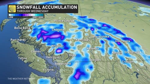
While folks around Metro Vancouver may have heard some rumbles of thunder through the night, higher up in the mountains, folks may be waking up to a slurry of wet snow on the ground.
YOUR MAY OUTLOOK: Spring into summer or a stalling spring ahead, Canada?
Wednesday and beyond: Remaining unsettled through the end of the month
Heavy shower activity diminishes quickly across the South Coast, but with a trough lingering in the Interior, there’s a renewed risk of non-severe thunderstorms across the central Interior.

Another opportunity for thunderstorms will develop across southeast British Columbia on Thursday.
No major storms are in sight for next week, but more upper-level troughs are forecast to roll across the province to finish off May –– keeping things wetter than normal and a little below seasonal across the south.
Stay tuned to The Weather Network for your latest forecast across British Columbia.

