7 DAY OUTLOOK — Some nice sunshine for the next two days


PRECIPITATION FALLING FROM THE SKY, BUT THE GROUND NEVER GETS WET?
Maybe you’ve seen precipitation falling from the clouds, but the ground never gets wet. Doppler radar sees the rain as well, but the region remains dry. What you’re experiencing is virga. Virga is streaks or wisps of precipitation that falls from the clouds into a dry air mass. The rain evaporates before it can reach the ground.


WGN WEATHER HEADLINES
Today a few degrees above normal with NW winds—but as high pressure centered over the southeastern US moves a bit to the east—the clockwise winds around high pressure will result in Chicagoland winds to come out of the warmer SW. Those will send temps soaring into the 60s likely for several days in a row.
More clouds on Tuesday with a chance of some late-evening showers. Wednesday a few peeks of sun and mild temps with a chance of showers/t’storms in the later part of the day. Thursday looks like the soggiest day of this coming week. And St. Patrick’s Day weekend will have some showers and seasonal temps. From this distant viewpoint, I’m optimistically thinking we’ll be dry for the dying of the Chicago River and the downtown parade on Saturday with some seasonal temps. Sunday could see more clouds and showers (and yes, a chance of snow showers) for the South Side Irish and NW Chicago parades.
WGN Weekly Climate Report: Finally a taste of actual March weather as we wrapped up the first full week of March including our first days of this year of 70+ degree temps. Some soaking rains on Friday helped boost our rainfall total for the month to well above normal at O’Hare—which can be nice for farmers and gardeners since we have zero snowpack at all to replenish soil moisture.
There is some snow in the Midwest—though zero around here. Mostly that snow can be found in northern parts of lower Michigan and the UP. Some snow this weekend has blanketed areas from Cleveland northeast up through the eastern Great Lakes and into New England.
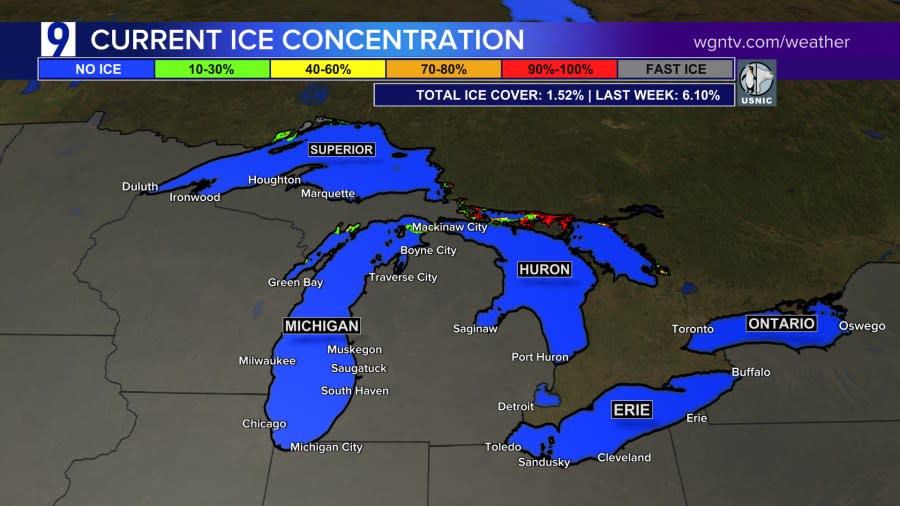
Great Lakes ice continues to diminish—and remains at the lowest levels of ice coverage ever recorded since record keeping began a half century ago. This week only about 1% of the Great Lakes are covered with ice. Ice coverage plays a big role in protecting shores from erosion during winter and spring storms, part of the life cycle of many fresh water fish, and lake ice prevents large quantities of lake effect snow.
As we get into March and start thinking about gardening and farming—we’re seeing some low level drought conditions creep back into parts of Chicagoland. Much drier conditions persist to the west of Chicagoland. But the good news for these agricultural concerns is that we’re expecting some rain at times for the second half of the coming week.
TEMPERATURE AND PRECIPITATION OUTLOOKS FOR MARCH 16 TO MARCH 24, 2024


For the latest news, weather, sports, and streaming video, head to WGN-TV.

