The 3 potential paths that Hurricane Matthew will follow
UPDATE: Oct. 5, 2016, 4:47 p.m. EDT Computer model runs during the day on Wednesday show that the coast-hugging boomerang track, detailed below, is looking increasingly likely. This would bring hurricane-force winds to much of eastern and even parts of central Florida on Thursday into Friday, along with storm surge flooding at the coast.
Hurricane Matthew is lashing the Bahamas on Wednesday with life-threatening winds and storm surge flooding, and it appears to be on a course that is a weather forecaster's worst nightmare: paralleling the highly populated east coast of Florida.
Any wobble in the storm's direction could, without much notice, bring the worst of the major hurricane's winds and heaviest rains onshore, or keep them off the coast, sparing the Sunshine State from much damage in the end.
SEE ALSO: That Hurricane Matthew forecast you keep seeing may not mean what you think
Here are three forecast scenarios, going from most likely to least likely, noting that none are a sure bet at this point.
One thing is very clear, though, which is that the storm is very likely to grow stronger and larger as it pounds the Bahamas. This is because it is traveling across extremely mild ocean waters — some of the warmest of anywhere in the North Atlantic basin — and because atmospheric conditions are also ideal for intensification.
This means that the storm that approaches Florida, Georgia and South Carolina may be a Category 4 storm.
The parallel boomerang
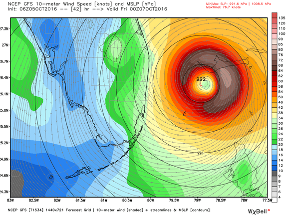
Image: weatherbell analytics
The most likely track of the storm, based on computer model guidance, storm observations and lessons learned from past hurricanes, would bring the storm through the central and northern Bahamas through Thursday morning, to a position east of Fort Lauderdale, Florida.
The storm would then track north-northwestward on Thursday and Friday, with the eye located between 20 and 100 miles off the coast of Florida. This would be close enough to spread hurricane force sustained winds of greater than 74 miles per hour across the vulnerable, highly populated Florida coastline from Miami northward to the Florida-Georgia state line.
The worst of the weather would hit most of Florida from Thursday morning into Friday night, with the potential for damaging winds, heavy rainfall and a storm surge high enough to bring about 3 to 5 feet of water above the typical high tide level onto the coast.

Image: noaa
One part of the Florida coastline that sticks out a bit farther to the east, making it slightly more vulnerable to Hurricane Matthew, is Cape Canaveral, Florida, which is vulnerable to sea level rise and storm surge flooding.
Ironically, the next-generation U.S. weather satellite, known as GOES-R, is sitting in a facility nearby Cape Canaveral, in Titusville, Florida, in preparation for its launch on Nov. 4. That satellite cost more than $1 billion to construct, and any delays in launching it could compromise the country's early warning system for weather hazards, such as a hurricane.
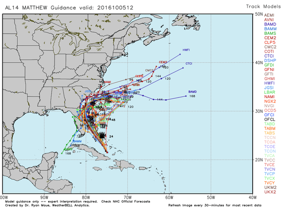
Image: weatherbell analytics
The most likely storm track also takes the storm off the coast of Georgia and South Carolina as it turns to the northeast and then nearly due east, deflected by a weather system to its north.
This forecast scenario would prevent the worst hurricane impacts, such as widespread storm surge flooding, in low-lying vulnerable regions like Charleston, South Carolina, where evacuations have been taking place since Tuesday night.
Interestingly, this track leaves open the possibility that the eye of the storm won't cross the U.S. coast in Florida, or any other state for that matter (at least not through this weekend). This would keep the record period without a major hurricane landfall going. The country has not had a landfalling Category 3 or stronger storm since Hurricane Wilma hit Florida in 2005.
2. The coast-hugging boomerang
There is also the possibility that the storm will hug the coast, and possibly cross over the coast of Florida as it moves northward on Thursday and Friday. This is closer to a worst-case scenario for people living along the I-95 corridor in the state.
This scenario would worsen the storm's impacts across the eastern portion of the state, extending hurricane-force winds inland and potentially increasing the storm surge flooding problem. One of the major computer models used to predict the weather, the Global Forecast System or GFS, shows the storm making landfall as a Category 4 storm near Cape Canaveral, Florida, and then following the coast all the way north to Jacksonville.
GFS 12z now landfalls Major Hurricane #Matthew along Florida space coast ... Melbourne to Daytona Beach late Thurs / early Friday pic.twitter.com/oqM1hkkD6O
— Ryan Maue (@RyanMaue) October 5, 2016
This could cause a devastating storm surge and widespread, potentially catastrophic wind damage across a broad stretch of expensive real estate, including the city of Jacksonville.
In a coast-hugging scenario, Hurricane Matthew would then recurve along the Georgia and South Carolina coastlines, bringing hurricane force winds ashore along both states, before moving more to the east in response to a weather system developing across the Northeast.
This would heighten the storm surge flooding threat in Charleston, which has seen a spike in so-called "nuisance" flooding on sunny days due to sinking land and rising sea levels from global warming.
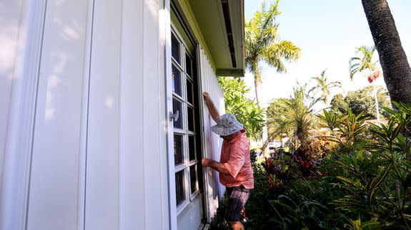
Answering many who have asked, I live inland from Ft. Lauderdale and am finishing putting up my #hurricane shutters today. #Matthew
— Dr. Rick Knabb (@NHCDirector) October 5, 2016
Again, more computer models are favoring a slightly further offshore solution, but history argues for the possibility of a surprise with this storm.
As in track number one, the term "boomerang" implies that the storm will not simply disappear off into the storm graveyard of the Atlantic. Instead, some computer model projections are suggesting that Hurricane Matthew will turn back to the south and then possibly to the west, striking Florida from the east early next week.
That scenario is intriguing, and worrisome for many, but not the primary concern during the next few days.
3. A swing and a miss
It's also possible — but not terribly likely — that the storm will emerge from the Bahamas at a more easterly longitude than is currently expected, and remain far enough off the eastern coast of Florida to bring hurricane force winds ashore.
A forecast near coast means small shifts can cause big changes to local impacts expected in your county. Prepare & stay informed. #Matthew pic.twitter.com/Mh8E5HCbeR
— Levi Cowan (@TropicalTidbits) October 5, 2016
This would be the best-case scenario for property owners and many businesses in Florida, not to mention the insurance industry that has lost billions in past hurricane seasons when multiple storms have struck.
However, the consistency among all of the most reliable computer models — most of which have been fed extra spoonfulls of weather data painstakingly gathered by research aircraft, extra weather balloon launches and other means — argues against this scenario.
Right now, the state most likely to see far less severe impacts than were in the cards just 12 hours ago is South Carolina, where an early turn to the east would spare the state, while a late turn could blast the coast with winds, torrential rains and coastal flooding not seen in more than a decade.
