2024 expected to be La Niña year. What that means for hurricane season, Florida residents
All signs continue to point to the formation of La Niña this summer.
That's not good news for Florida residents and the 2024 Atlantic hurricane season, especially when combined with record warm water temperatures.
While La Niña is a natural occurrence that happens in the Pacific Ocean its formation has a huge impact — including its counterpart, El Niño — on weather in the U.S., and those impacts include affecting the formation of hurricanes and tropical storms in the Atlantic basin.
Here's what La Niña is and why Florida residents should care, especially when preparing for the upcoming hurricane season.
What is La Niña?
La Niña is a natural climate pattern marked by cooler-than-average seawater in the central and eastern Pacific Ocean.
It is one of the main drivers of weather in the United States, especially during the late fall, winter and early spring. It's the opposite to the more well-known El Niño, which occurs when Pacific Ocean water is warmer than average.
La Niña is coming: It could worsen hurricane season and affect US weather, forecasters say
What impact does La Niña have on the Atlantic hurricane season?
The Atlantic hurricane season runs from June 1 through Nov. 30.
La Niña can bring more tropical cyclones in the Atlantic basin by weakening wind shear. The Atlantic basin includes the northern Atlantic Ocean, Caribbean Sea and Gulf of Mexico.
When there is no or reduced wind shear, that allows tropical cyclones to develop and intensify.
Wind shear, when present, tears apart developing storms or can even prevent them from forming.
La Niña, El Niño strongest during the fall, busiest portion of hurricane season
Both La Niña and El Niño tend to reach peak intensity from fall through winter, according to AccuWeather.
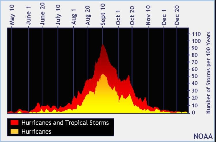
The busiest portion of the Atlantic hurricane season occurs from August through October, with the peak being Sept. 10.
Warm water, La Niña are not good combination when it comes to tropical cyclones
In February, AccuWeather started "sounding alarm bells for a supercharged season in 2024 with a risk for many storms," said Jon Porter, AccuWeather chief meteorologist.
The combination of a building La Niña and historically warm water will lay the groundwork for a blockbuster season, AccuWeather said.
Besides La Niña, adding to forecasters' concerns are the record high water temperatures, which help fuel tropical cyclones.
In early March, the European Centre for Medium-Range Weather Forecasts was predicting a "very busy" Atlantic hurricane season through September — two months short of the entire season — with about 17 named storms and nine hurricanes, according to a tweet from Philip Klotzbach, meteorologist at Colorado State University specializing in Atlantic basin seasonal hurricane forecasts.
La Niña and its impact on prior hurricane seasons
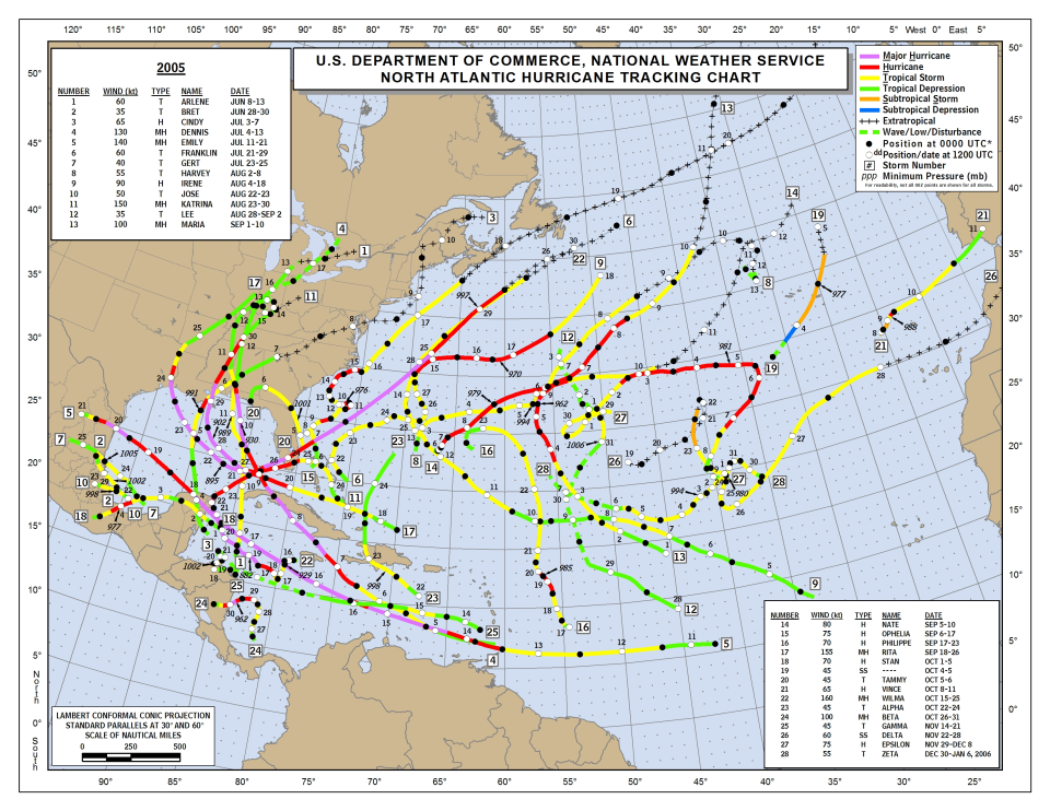
Both 2005 and 2020 were La Niña years.
Hurricane Katrina, which struck the coasts of Mississippi and Louisiana, was one of 27 named storms that developed in 2005, which broke the old record of 21 named storms set in 1993, according to the National Hurricane Center.
It's not the only record set in 2005:
14 hurricanes
8 major hurricanes of Category 3 or higher
7 storms made landfall in the U.S., just behind the record of 8 storms set in 1916 and 2004.
Most destructive in U.S. Damage estimates are more than $100 billion.
The 2005 hurricane season also was the first time the entire list of Atlantic hurricane names was used and forecasters dipped into Greek letters to name storms. Tropical Storm Zeta formed on Dec. 30.
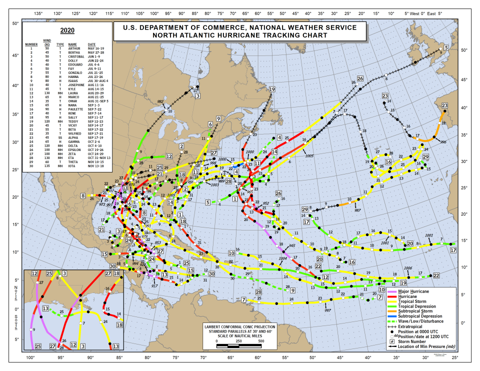
The same thing happened in 2020, when there were 30 hurricanes, breaking the 2005 record. Of those 30 storms, 13 were hurricanes, six of which were major hurricanes.
Twelve named storms made landfall in the contiguous U.S., breaking a record held since 1916 of nine storms, according to the National Hurricane Center.
The strongest of the storms making landfall in the U.S. was Hurricane Laura, which made landfall in Louisiana as a Category 4 storm. Laura was the third of five named storms to make landfall in Louisiana in 2020, the most on record for any state in one year.
What happened to Greek alphabet names for tropical storms and hurricanes?
In March 2021, the World Meteorological Organization announced Greek names would no longer be used.
The use of Greek alphabet names "creates a distraction from the communication of hazard and storm warnings and is potentially confusing," the WMO said.
The decision was made after a record-breaking season in the Atlantic basin in 2020, which not only used the entire list for the year but also used Alpha, Beta, Gamma, Epsilon, Zeta, Eta, Theta and Iota.
Contributor: Doyle Rice, USA Today
This article originally appeared on Treasure Coast Newspapers: 2024 Atlantic hurricane season and what La Niña means to Florida

