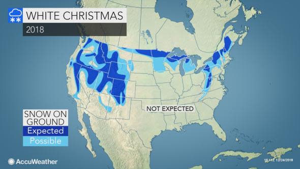
2018's white Christmas restricted to the interior Northeast, Upper Midwest and mountainous West
While many across the country will be hoping for a white Christmas this year, the areas expected to have some white on the ground will be restricted to the northern tier of the country, and in the higher elevations of the West.
The standard for a white Christmas is an inch of snow on the ground during the morning, according to the National Weather Service (NWS).
The regions most likely to have a blanket of snow on the ground this Christmas include the interior Northeast, the Upper Midwest and the mountains of the West.
Northeast
A storm arrived in time for part of the Northeast to be treated to a white Christmas, but it failed to produce widespread snow.
While fresh snow spread over the central Appalachians, rain dampened the Interstate 95 corridor from Washington, D.C., to Philadelphia and New York City on Sunday night.
The air was cold enough for snow to streak over southern New England on Monday, but most of the snow did not whiten the ground.
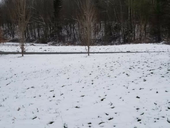
Snowfall right before Christmas continued to cover the ground near Mansfield, Pennsylvania, on Dec. 24, 2018. (Photo/Bill Baker)
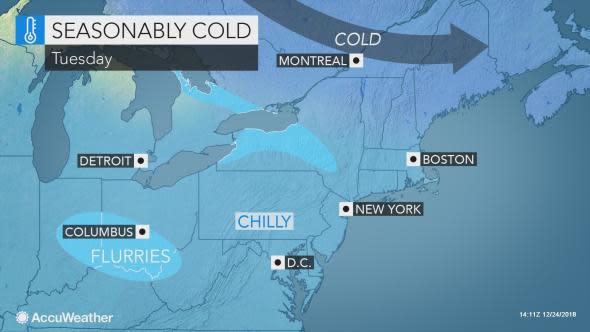
"Snow showers and even a few heavier squalls will continue downwind of Lake Erie and Lake Ontario into Monday night," said AccuWeather Meteorologist Steve Travis.
Over 3 inches fell around the Syracuse, New York, area on Monday, ensuring a white Christmas that area.
Aside from a few flurries lingering over western and central New York, Christmas Day will be dry and seasonable across the Northeast.
Upper Midwest
As of Monday, a few inches of snow continued to blanket the ground across eastern North Dakota, Minnesota, northern Wisconsin and through Michigan's Upper Peninsula and northern parts of the Lower Peninsula.
With a reinforcing shot of cold air, most of this snow is expected to stick around into Christmas Day.
With no snow on the ground across Nebraska and through the central Plains, and mild temperatures expected to continue through the holiday, a white Christmas is not expected across the rest of the Plains.
Those hoping for a white Christmas will be disappointed to learn that snow, though along with major travel disruptions, is on the way to the northern and central Plains Wednesday and Thursday.
Mountainous West
The higher elevations of the West, from Colorado to Washington and California, are expected to enjoy a white Christmas.
"Most of the snow will already be on the ground prior to Christmas Day in the West, with just a few exceptions," said AccuWeather Senior Meteorologist Alex Sosnowski.
A moderate snow depth was already in place as of Monday across the Rockies from western Colorado to Idaho and western Montana, as well as in the Sierras and across the Cascades of Oregon and Washington.
"A storm system will dive southward on Christmas Eve, spreading rain and snow from southern Oregon and Northern California into Nevada," said Sosnowski.
This snow will bring a fresh blanket of snow for the mountainous areas that already have several inches of snow on the ground. But this could also bring some snow to the lower terrain across eastern Oregon and much of Nevada.
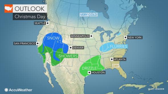
A push of cold air following the storm is likely to keep any accumulations around into Christmas Day. Some areas may also receive additional snow on Tuesday.
As this storm moves farther east, it is likely to bring a little snow into Utah and parts of Arizona on Christmas Day. Snowflakes may fly around Flagstaff and Salt Lake City, but it may take until Tuesday night for the snow to accumulate in the latter city.

TradeWx offers protection against financial risks of snow accumulation and other weather events. Learn more on TradeWx.com.

