Miracle or mirage? Atmospheric rivers end California drought year with heavy snow and rain
After the driest start to any year on record, California will end 2022 with snow-capped mountains, soaked roadways and — in some places — flood warnings.
The soggy end to an otherwise bone-dry year came as something of a surprise. Only weeks earlier, officials sounded the alarm about a rare third appearance of La Niña — a climate pattern in the tropical Pacific that is often associated with dry conditions in the state. On Thursday, skiers in Mammoth enjoyed some of the deepest snow in the nation, while in Los Angeles, a steady drizzle signaled stronger storms to come.
Officials said the parade of atmospheric rivers dousing the state will probably continue in the days ahead, providing a glimmer of optimism after a year marked by water restrictions, drying wells and perilous lows on the Colorado River. But though California's wet season has defied expectations so far, the pattern must persist to truly undo several years of significant rain deficits.
"The moisture that we're getting now is a big help, but we need more — a lot more — to really put a major dent in the drought," said Richard Heim, a meteorologist with the National Centers for Environmental Information and one of the authors of the U.S. Drought Monitor.
Still, the damp December has come as a welcome change. While the drought monitor shows nearly 81% of the state under severe, extreme or exceptional drought, that's a notable improvement from three months ago, when about 94% of the state was classified in the three worst categories. Heim said next Thursday's update should show even more gains.
"When we're dealing with drought in the West, in some regards we have to take it slow in showing improvement because reservoirs take forever to refill and you really need a good mountain snowpack," he said. "And we don't know if we have a good mountain snowpack for the snow season until somewhere around April 1."
State climatologist Mike Anderson of the Department of Water Resources said the storms could signal the decay of La Niña, which arrived as anticipated but started to weaken around the winter solstice on Dec. 21, when Earth stopped tilting away from the sun in the Northern Hemisphere. Around the same time, regional high-pressure systems weakened, which allowed some of the storms to push through, he said.
"We're kind of seeing things that are more in tune with what we would expect climatologically, and lot of it has to do with that high pressure yielding in its strength," Anderson said. "In previous winters, it hung in there strong and prevented storms from making their way into California."
The late December storms have also delivered some improvements when it comes to the state’s snowpack and reservoirs. California's snow water equivalent, or the amount of water contained in the Sierra Nevada snowpack, was at 156% of normal for the date on Thursday.
The state's two largest reservoirs also saw gains, with storage in Lake Shasta at 1.47 million acre-feet, up from 1.4 million at the start of December, and Lake Oroville at 1.12 million acre-feet, up from 965,000 at the start of December, Anderson said.
But he cautioned that more moisture is needed. Though high for the date, the snow water equivalent is still only 51% of its April 1 average, meaning that if no more rain and snow were to fall, the wet season would end with about half of what's needed. Similarly, though Shasta and Oroville have improved, both remain well below normal for the time of year.
"It just has to sustain itself, because we still have two more of the wettest months of the year to go, and we really need them to be wet as well, where this year they were record dry," Anderson said.
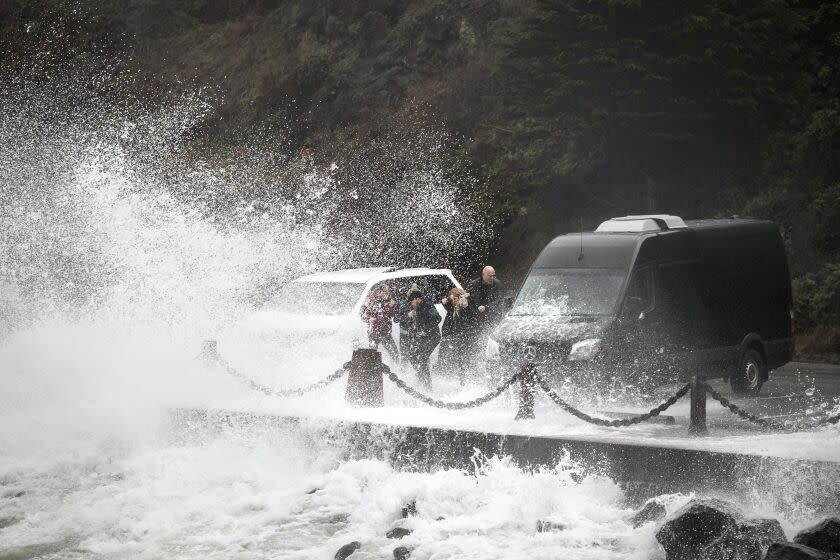
But though the storms have brought welcome moisture, they have also created instances of havoc across the state. Winter hazards, including snow, ice and fog, have already prompted some road closures in portions of Central and Northern California, and travel could be "near impossible" in some places through the weekend, the National Weather Service said.
Hannah Chandler-Cooley, a meteorologist with the weather service in Sacramento, said the atmospheric rivers are coming from the tropics, not the Arctic, so they are warm systems that could bring rain instead of snow to elevations as high as 7,000 feet. Flood watches and warnings have been issued in several areas, including Lake Tahoe, Hanford and Sacramento, where several inches of rain are expected to fall.
Officials in the region are particularly concerned about flooding in communities along the Cosumnes, Mokelumne and Sacramento rivers, as well as potential urban flooding in areas with poor drainage and low-lying areas and roadways, she said.
"There will be small towns and homes and roads and farms that could be impacted, but it will be a bit more localized to just those few river points, and not all of the river systems in Northern California," she said.
📡 Radar Update | 5:30 AM
Widespread precipitation continues across interior NorCal. Periods of rain and mountain snow will continue through tonight, with a brief break possible by midday. More widespread precipitation arrives Friday through Saturday. #cawx pic.twitter.com/5n5rdmyy0F— NWS Sacramento (@NWSSacramento) December 29, 2022
Despite the potential hazards, the storms are undoubtedly beneficial for the parched state. The latest outlook from the National Oceanic and Atmospheric Administration's Climate Prediction Center now shows an equal chance of above- or below-average precipitation in Northern California in January, but it's not a guarantee.
Heim recalled that 2021 saw a similarly wet December, which was then followed by California's driest-ever January through March on record in 2022. He feared a similar pattern could play out next year.
"A few months of really wet weather, well, it's not going to make much of a dent in these deficits that have accumulated over the years and are reflected in the low reservoirs," Heim said. He added that Lake Mead, the largest reservoir on the Colorado River, has more than 20 years of precipitation deficits to make up for.
But such dire conditions seemed a world away from the scene at Mammoth Mountain on Thursday, where officials were bracing for up to 5 feet of snow on top of the 2 to 3 feet received earlier this week.
"This has been an incredible start to the season here at Mammoth,” Lauren Burke, the resort’s spokesperson, told The Times. "It is a true winter wonderland up here."
Times staff writer Grace Toohey contributed to this report.
This story originally appeared in Los Angeles Times.

