Idyllic places blighted by A-bombs
It is, in many ways, the ghost that will not stop howling. This week has seen the spectre of the nuclear explosion rattle its chains again – with the revelation that France under-reported the levels of radiation emitted by its atomic test programme in the South Pacific in the mid- and late-20th century. The findings, unearthed by the French investigative website Disclose, with the assistance of American and British researchers, throws open a door for thousands of residents of French Polynesia to pursue compensation for the health consequences of the bomb blasts – which occurred between 1966 and as recently as 1996.
The news is hardly surprising. Governments have rarely been open about the effects of unleashing clouds of toxic matter into the atmosphere – and while it is French secrecy which stands in the dock this month, Paris has not been alone in smearing radiation across the planet. France is, of course, one of the five official “nuclear weapon states” (NWS), along with the USA, the UK, Russia and China, while three other nations – India, Pakistan and North Korea – have openly conducted tests. Add in presumptions about the nuclear status of Israel and Iran, and the atomic map extends to four continents.
Its shadow stretches much further – into arid landscapes, areas of placid beauty, and remote islands supposedly removed from trouble’s path. In the 76 years since the first nuclear device was detonated – in the Jornada del Muerto desert of New Mexico in July 1945, as part of the Manhattan Project – locations from the waters of tropical oceans to the sands of the Sahara have witnessed the grim ascent of a mushroom cloud. Most are still scarred by the experience, but some have become places of fascination (dark tourism, if you will), while others are inching towards a brighter existence in a century which – you might hope – is less keen to flirt with global armageddon at the push of a few buttons.
French Polynesia
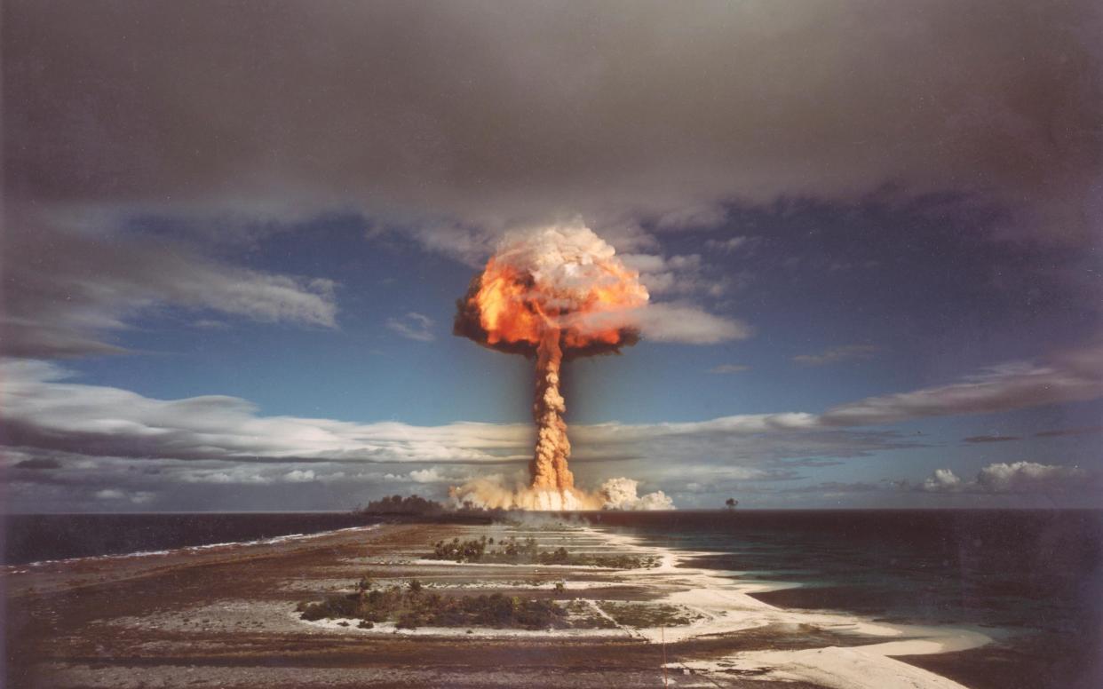
France conducted some 180 nuclear tests in the Pacific region in the course of 30 years. The majority took place at Moruroa Atoll – although others occurred at the neighbouring Fangataufa Atoll, 23 miles south, on the east flank of the broader Tuamoto Archipelago.
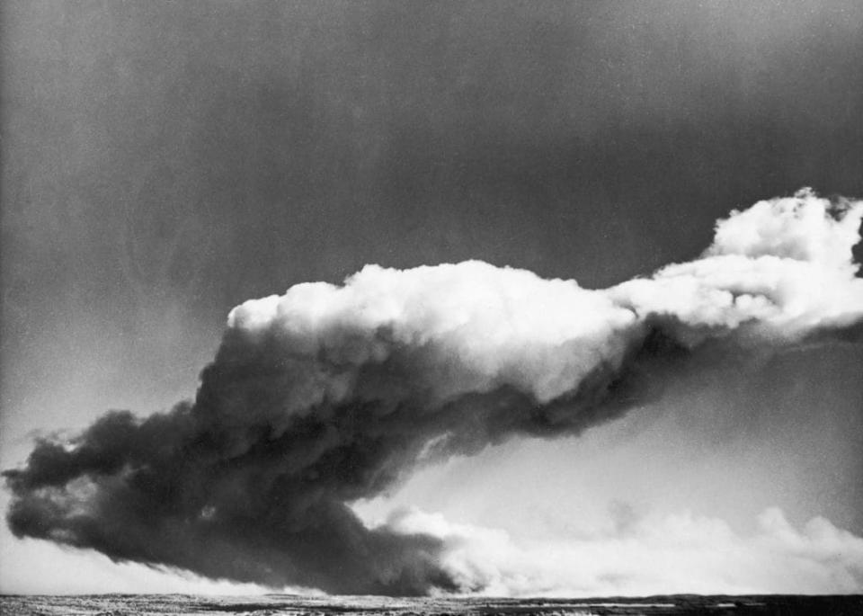
Moruroa does not differ in geography from the rest of French Polynesia – spreading out for 17 miles as a ring of low-slung coral islets encircling a lagoon. It was this sheltered lake which bore the brunt of the experiments, firstly on July 2 1966, with the detonation of a plutonium fission bomb that – according to a later study by Greenpeace – sucked out all the water from the lagoon, before “raining dead fish and molluscs down on the atoll”.
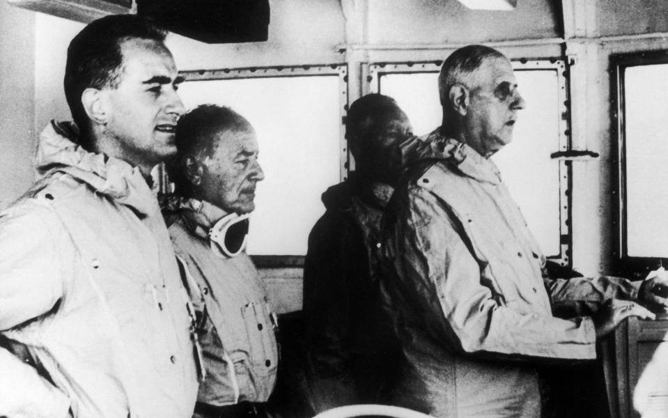
These activities usually took place amid strict secrecy – but they were not without interested observers. Remarkably, French president Charles de Gaulle was present at Moruroa on September 10 1966, when a nuclear device was set off as it hung from a balloon. Protests by New Zealand – which sent two frigates to the atoll in 1973 – saw the experiments driven underground, into tunnels drilled into the volcanic rock. But this did not stem the controversy. A system failure in July 1979, which saw a device become wedged only halfway down its shaft at a depth of just 400m, sparked land slippage and a tsunami. Anger only intensified when France conducted a further series of tests in 1995 and 1996, mere months before the Comprehensive Nuclear Test Ban Treaty was adopted by the United Nations General Assembly. The radioactive fallout of the process is estimated to have affected 110,000 French Polynesians – this week’s report pays special attention to the test which took place at Moruroa on July 17 1974, where the subsequent atomic cloud took an unexpected trajectory – drifting across Tahiti and its capital Papeete.
The situation raised further bleak headlines in the summer of 1985. Frustrated at Greenpeace’s ongoing opposition to the tests, agents for the DGSE (Direction Generale de la Securite Exterieure; the French foreign intelligence service) planted two bombs on the hull of the environmental group’s ship the Rainbow Warrior on the night of July 10, as it was docked in Auckland. The explosions killed the Portuguese-Dutch photographer Fernando Pereira, sank the vessel – and triggered a wave of international condemnation.

Algeria
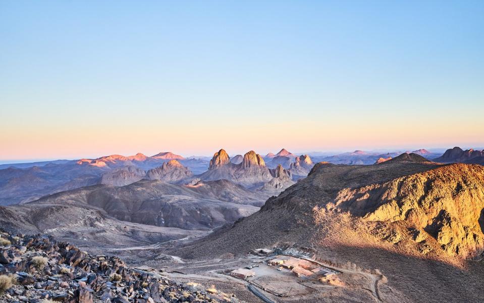
You have to travel a long way into Africa’s biggest country to find the location of France’s first nuclear explosion. Reggane is the last town you reach if you head south on the Tanezrouft Track – the lower half of Algeria’s N6 highway, which cuts across the Sahara to Mali. It is a remote dot on the map, marooned some 900 miles from the capital Algiers. It is a small place as well, with a population of 20,000 largely Berber inhabitants, scratching out a living close to the southernmost oasis of the Tuat region. Beyond it lies the dunes of the planet’s greatest desert, sand swallowing sand all the way to the horizon.
It was for this reason that France decided it could conduct nuclear experiments here – in an unseen shard of what was then its colony. The timing was contentious. When that first mushroom cloud billowed, on February 13 1960, France was already embroiled in the eight-year war (1954-1962) that would see Algeria wrench itself out of foreign control. Gerboise Bleue (Blue Jerboa – named after the Saharan rodent) went ahead even as bullets were flying elsewhere; a plutonium-filled bomb detonated at the top of a 100m steel tower. Three further explosions would take place at the site over the next 15 months (Gerboise Blanche, Gerboise Rouge, Gerboise Verte), but the first was by far the biggest. Indeed, at that point, it was the biggest test blast that had ever been unleashed. Fat Man, the bomb that was dropped on Nagasaki in August 1945, was “only” a third as powerful.
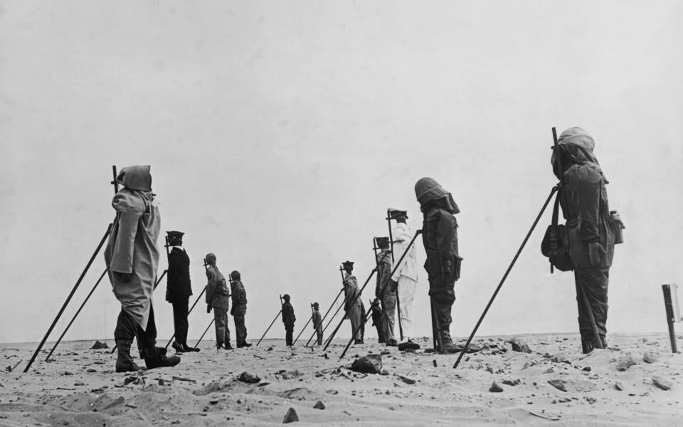
The French media reacted exultantly. Africa recoiled – Morocco withdrew its ambassador from Paris; Ghana froze all French assets within its borders. But the experiments continued – even after Algeria had won its independence. Eighteen tests were conducted at a new underground facility near In Ekker – an even more remote village, in the Hoggar Mountains – between November 1961 and February 1966. These were not without issues. On May 1 1962, the “Beryl Incident” saw a cloud of dust escape the improperly sealed shaft that had been built to contain it, exposing more than 100 people to radiation – including France’s Minister of Scientific Research, Gaston Palewski, who would die of leukaemia 22 years later. In 1999, a survey of the site by the International Atomic Energy Agency found that it was still contaminated, and a threat to the local nomadic population.
Western Australia
Britain ran ahead of France in the race to be a nuclear power. Having been rebuffed by the USA in a request to share the full results of the Manhattan Project, London embarked on its own bomb-building programme. The first bitter fruit of it was Operation Hurricane – the detonation of a plutonium implosion device in the Montebello Islands of Western Australia, just before 8am on October 3 1952.
The explosion caused one notable “fatality”. HMS Plym was a veteran of the Second World War – a River-class frigate, launched in 1943, which had served in the anti-submarine convoy in the Atlantic. It was within its hull that a 25-ton atom bomb was set off, as it was anchored off Trimouille Island (to simulate the consequences of a similar device being smuggled into British port).Derek Hickman, an engineer observing the blast from a distance, remarked that all that remained of the Plym “were a few fist-sized pieces of metal that fell like rain, and the shape of the frigate scorched on the sea bed.” A blackened paste washed up on the shore.
The fallout cloud spluttered upwards to an altitude of 10,000ft (3,048m). But although it drifted out to sea, as had been the intention, it would reverse its direction and blow across the Australian mainland. Radiation would be detected as far away as Brisbane, on the Queensland shore. Nonetheless, two further blasts were staged in the islands – on Trimouille and the neighbouring Alpha outcrop – in the May and June of 1956 (as part of “Operation Mosaic”), before Britain’s nuclear test programme was transferred elsewhere.
The Montebello Islands were chosen for their location – they lie 80 miles off the Pilbara coast of north-western Australia. But they suffered for their isolation. Radiation was still apparent in the early 1980s, and access to Trimouille was prohibited until 1992. Australia had agreed to the area being a nuclear test site in 1951, but has taken a different approach in the new millennium – the archipelago is now a conservation park. Wildlife has been reintroduced – with birds like sooty oystercatchers, and marsupials such as the wallaby, transferred in from nearby Barrow Island. An obelisk marks the site of the explosion on Alpha, but visitors are advised not to linger long – or collect souvenirs – on either island.

South Australia
Britain’s nuclear ambitions would also impose themselves on the Australian mainland. In October 1953, Operation Totem saw a pair of tests conducted at Emu Field, in the South Australian desert. This was a far less remote location than the Montebello Islands, “just” 700 miles from the state capital Adelaide, and the radioactive cloud from the first test – Totem 1 – would drag its tendrils north-east across the landmass.
The site is now regarded as safe to visit (though permission is needed; it forms part of the RAAF Woomera Range complex) – and provides proof of the ferocity of the blasts in vitrified sand and scorch rings. The epicentre of Totem 1 is marked with an obelisk which declares that “radiation levels for a few hundred metres around this point may be above those considered safe for permanent occupation”. It can be part of a particularly hardy journey into the Australian Outback along the Anne Beadell Highway – the 823-mile unsealed road between Coober Pedy (in South Australia) and Laverton in Western Australia, which passes Emu Field – and was partly constructed (between 1953 and 1962) to facilitate the nuclear experiments.
South Australia’s recollections of the second test site on its soil are much angrier. Though marginally closer to Adelaide (it sits some 140 miles south of Emu Field, about 500 miles north-west of the city) Maralinga is harder to reach. This partly explains why its desert landscape fell prey to seven weighty British nuclear tests between 1956 and 1963, mainly as part of Operation Buffalo (1956) and Operation Antler (1957). The area was left badly contaminated – and “clean-ups” in 1963, 1964 and 1967 undid only a little of the damage.
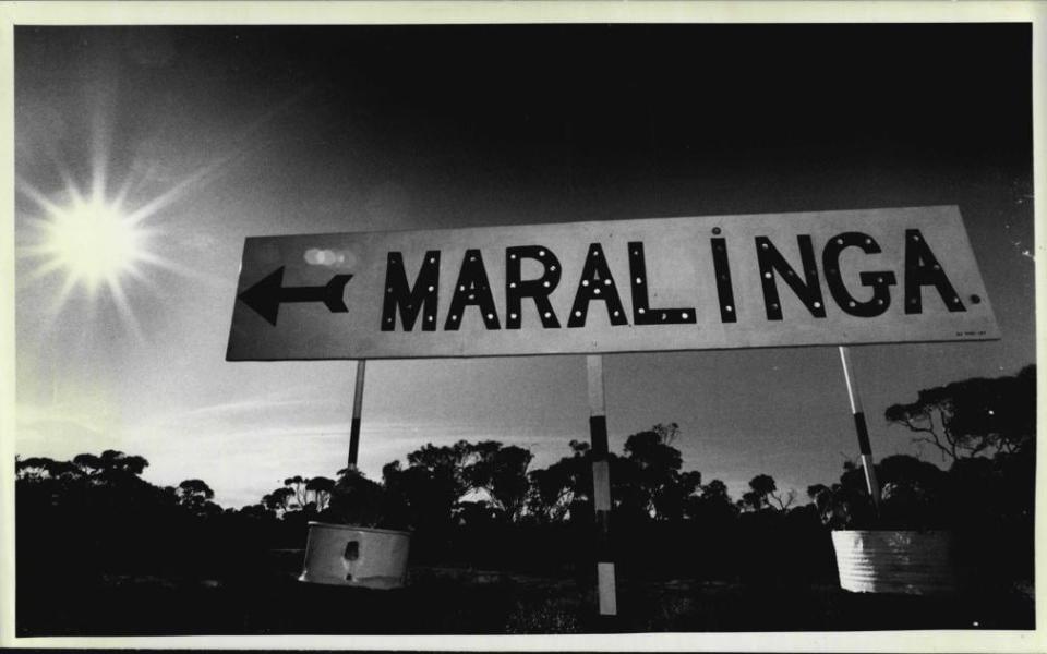
While, as with the Montebello Islands, the Australian government had given its consent for the tests, attitudes have – understandably – hardened significantly over time. A fuller rehabilitation of the area was attempted between 1996 and 2000, with the British government contributing an initial £20million of funding in 1993. But the test site and its legacy remain enormously controversial – even though the land was formally handed back to its indigenous guardians, the Maralinga Tjarutja, between 2009 and 2014. The radioactive stain has also seeped into the country’s culture as well as its ground. The Sydney band Midnight Oil are among the various Australian musicians to have addressed the topic – notably on the track Maralinga, on their 1982 album 10, 9, 8, 7, 6, 5, 4, 3, 2, 1.
Kiribati
Britain’s ambition to be the third power (following the USA and the Soviet Union) to possess thermonuclear weapons led it away from an increasingly unhappy Australia into the waters of the Pacific – where what is now Kiribati fell under the cross-hairs. This small oceanic nation gained its independence from the UK in 1979 – but only after it had endured the series of explosions that was Operation Grapple in 1957 and 1958. The procedure saw hydrogen bombs detonated above both Kiritimati and Malden Island – which sit, respectively, 1,340 miles and 1,760 miles south of the Hawaii capital Honolulu.
Both were, and are, the sort of islands which define the region in popular imagination – low sands and whispering palms. Both have claims to fame. Kiritimati is better known as Christmas Island – and, as of a realignment of the International Date Line in 1995, is one of the first places on earth to witness the dawn of a new year. It is not uninhabited – and, shockingly, wasn’t evacuated during the trials – its plantation workers left in harm’s way. Operation Dominic – 31 US tests – also made use of it as Cold War tensions heightened in 1962. Its population has grown significantly since, but the entire island is now a wildlife sanctuary, where birds like the Christmas Island warbler and red-tailed tropicbird thrive.

Malden Island was at least free of human footprints when Operation Grapple descended upon it. Or, at least, it was by that point. It is large enough – some 15 square miles of coral, framing an enclosed lagoon – that it had sustained life in another era. It was uninhabited when it was “discovered” by the American whaler Samuel Bunker in 1825, but ancient ruins on its north and south shores – 21 archaeological sites in total, with the remains of houses, temples and tombs – talk of an earlier Polynesian civilisation that had moved on long before bigger ships and military airplanes were plotting it on their charts.
The Marshall Islands
The USA had carried its nuclear plans into the Pacific long before Operation Dominic shook the skies. Between 1946 and 1958, it conducted 23 tests at Bikini Atoll, in the Marshall Islands. This was no small endeavour. In the summer of 1946, Operation Crossroads – the first and most significant part of the early trials – saw the detonation of the first two nuclear devices since the bombing of Nagasaki a year earlier. It involved the assembly of a ships’ graveyard – 95 warships deemed to be expendable; an enormous fleet – in the atoll’s lagoon. These were to be metal guinea pigs in experiments to assess the effects of targeting vessels at sea. The first device – Able – sank five of them on July 1; the second, Baker, was detonated underwater, and took down another eight on July 25.

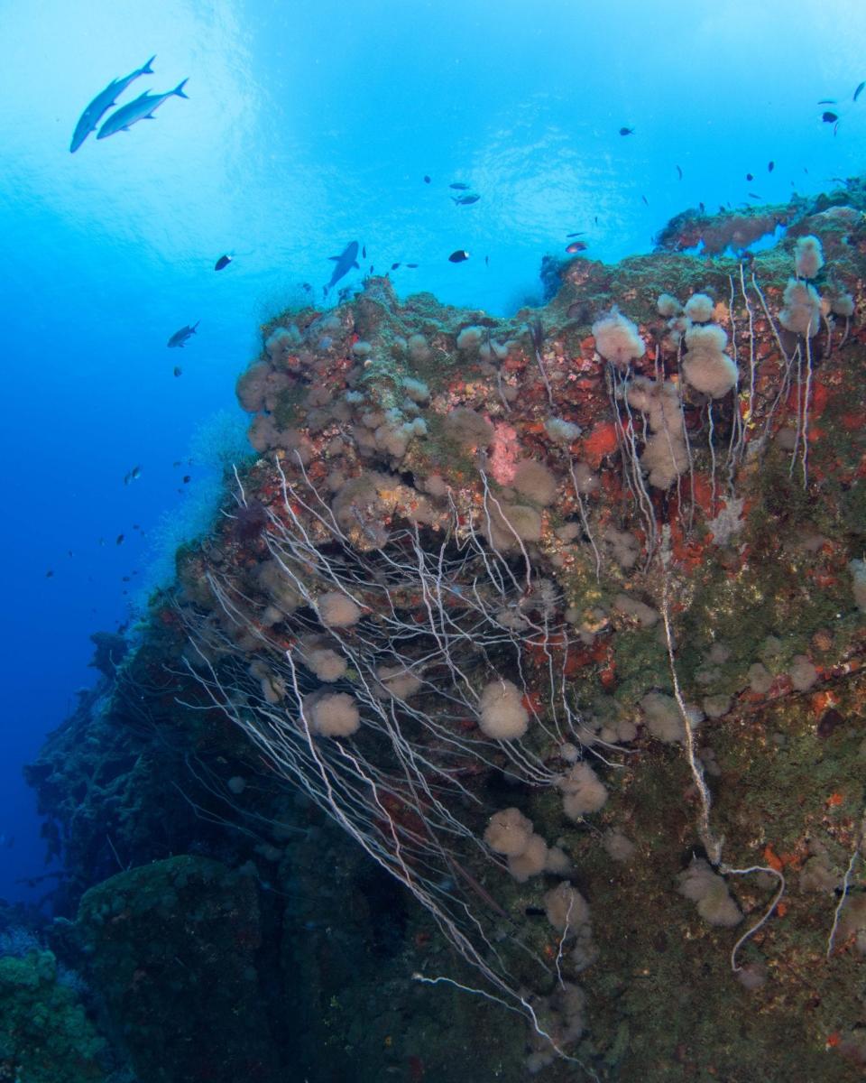
The ships were not the only “casualties” of the tests. The Castle Bravo experiment of March 1 1954 led to sizeable fall-out, showering the people of the surrounding Rongelap Atoll in radioactive ash. Notoriously, the debris also fell onto the 23 crew members of the Japanese fishing boat Daigo Fukuryu Maru (Lucky Dragon No.5), which had the ill fortune to be in the area. The outcry was loud. The ship is now preserved in its own museum in Tokyo – a quiet protest against nuclear weaponry. Bikini Atoll is much less accessible. Attempts to resettle the local population in 1970 were abandoned by 1980, after high levels of strontium-90 were found in its drinking water. Remarkably, scuba diving was authorised in 1996, allowing “adventurous” souls to inspect the remains of the likes of the USS Anderson, USS Arkansas and USS Saratoga in the depths of the lagoon.
New Mexico
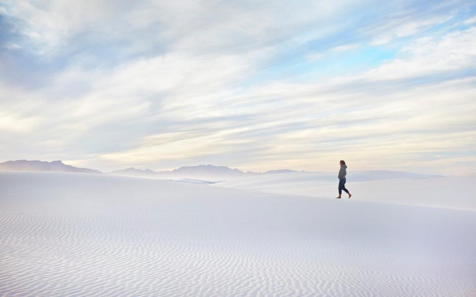
The Ground Zero of nuclear explosions – near Socorro in this south-western state – is now safeguarded as a National Historic Landmark. It was here, under the gaze of Robert Oppenheimer, that the Trinity test was conducted on July 16 1945. The site has been on the US heritage list since 1965. However, access is only possible twice a year, on special open days held on the first Saturdays of April and October, as the site is part of the active White Sands Missile Range (see wsmr.army.mil/Trinity/Pages/Home.aspx; the upcoming April open day has been cancelled due to the pandemic). For those who want to sample the harsh geography of the area which gave birth to the nuclear bomb, but cannot make such specific dates, the adjacent White Sands National Park (nps.gov/whsa) is indicative – its dunes of pale gypsum rising and falling below the ridge of the San Andres Mountains.
Nevada
Some of the most remarkable images of the nuclear age are those which show mushroom clouds in the heavens above the Nevada Test Site – where the US set off devices for much of the Fifties. That these experiments took place so close to human life – Las Vegas lies just 100 miles to the south-east – remains a source of astonishment. Particularly as Sin City revelled in the proximity, holding viewing parties, and even related beauty pageants.

Alaska
Look at it on the map, and you might surmise that, on location alone, Amchitka Island could have started the Third World War. This volcanic outcrop in the northern Pacific has been part of the USA since the Alaska Purchase of 1867. But it is also part of the Aleutian Islands – the archipelago, arcing like a necklace between continents, that is shared with Russia. Less than 600 miles – a hop and a skip in terms of the region – separate it from Bering Island, on the other side of the border. In 1965, when the USA selected Amchitka as a nuclear test site, these two “neighbours” were also on opposite sides of the Cold War.

Provocative? Surely. But enormous underground blasts were unleashed in 1965 and 1969 – and again at the start of the next decade. The Cannikin experiment of November 6 1971 unfurled as an explosion 400 times more powerful than the bomb which eviscerated Hiroshima – a gut punch to the island that caused landslides, and created a vast new lake.
The Amchitka and Cannikin tests played a direct role in the founding of Greenpeace. Five decades later, radiation levels on the the island are still being carefully monitored, although there are tentative plans to turn it into a wildlife preserve – by as soon as 2025.

